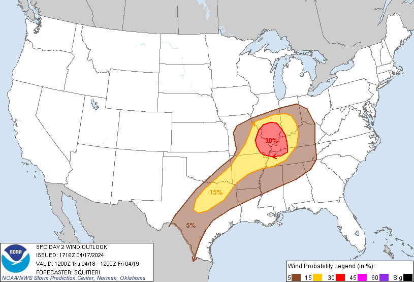
Probability of damaging thunderstorm winds or wind gusts of 50 knots or higher within 25 miles of a point. Hatched Area: 10% of greater probability of wind gusts 65 knots or greater within 25 miles of a point.
Day 2 Wind Risk
Area (sq. mi.)
Area Pop.
Some Larger Population Centers in Risk Area
30 %
41,830
4,630,428
St. Louis, MO...Evansville, IN...Clarksville, TN...St. Charles, MO...Florissant, MO...
San Antonio, TX...Indianapolis, IN...Austin, TX...Memphis, TN...Louisville, KY...
SPC AC 171716
Day 2 Convective Outlook
NWS Storm Prediction Center Norman OK
1216 PM CDT Wed Apr 17 2024
Valid 181200Z - 191200Z
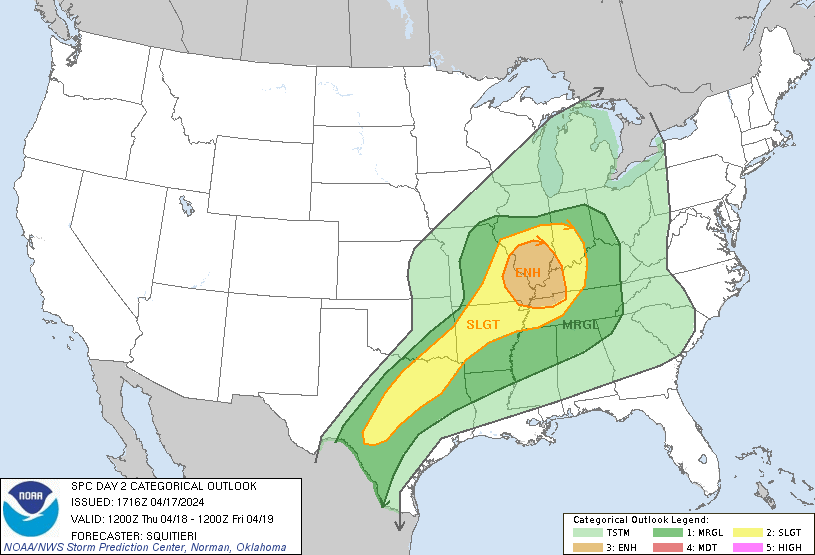
...THERE IS AN ENHANCED RISK OF SEVERE THUNDERSTORMS FOR PORTIONS OF
EASTERN MISSOURI INTO SOUTHERN ILLINOIS...EXTREME SOUTHWEST
INDIANA...FAR SOUTHWESTERN KENTUCKY...FAR NORTHWESTERN TENNESSEE...
...SUMMARY...
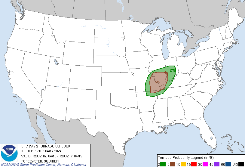
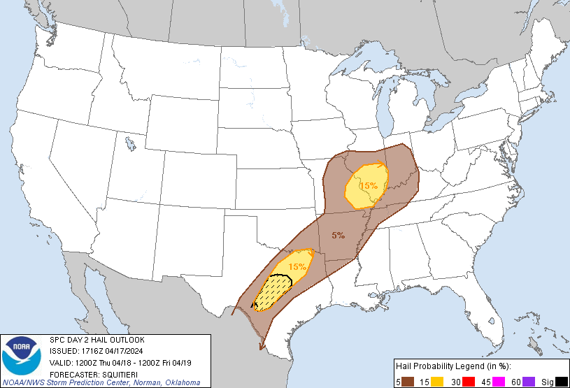
Strong to severe storms capable of several damaging gusts, large
hail, and perhaps a couple tornadoes, are likely tomorrow (Thursday)
from parts of the lower Ohio Valley into the southern Plains.
...Synopsis...
Mainly zonal flow aloft will overspread the CONUS tomorrow
(Thursday) as a mid-level trough traverses the northern Plains. In
response, a gradually weakening surface low will move from the
central Plains toward the OH Valley as a surface cold front sags
southward from the OH Valley to central TX through the day. Ample
low-level moisture, overspread by cooler temperatures aloft, along
with adequate deep-layer vertical wind shear, will precede the
surface cold front and support a risk for severe thunderstorms by
afternoon. Strong to severe thunderstorms will initiate off of the
cold front by afternoon from the OH Valley into TX, with all severe
hazards possible.
...MO into portions of the OH Valley...
A surface low will be traversing central MO/IL during the late
morning/afternoon hours, with thunderstorm development likely
underway along the cold front at the start of the period. As the
surface low continues to drift northeast, with the cold front
drifting southeast, diurnal heating will destabilize the warm sector
over the mid MS Valley, where an increase in convective coverage and
intensity is expected. Here, surface temperatures will peak into the
upper 70s to low 80s F amid mid 60s F dewpoints. 7-8 C/km mid-level
lapse rates will overspread a deepening/mixing boundary layer,
boosting SBCAPE into the 2000-3000 J/kg range. Deep-layer shear will
not be overly strong, but modest mid-level flow and associated
speed/directional shear will support low-level hodographs of modest
curvature and limited mid-level elongation. This shear/buoyancy
profile will support multicells (accompanied by wind and hail)
rapidly growing upscale into a mature MCS by afternoon. Given a
preceding mixed boundary layer, the MCS should efficiently produce
damaging gusts, warranting the introduction of Category 3/Enhanced
risk probabilities. Given modest low-level hodograph curvature,
embedded mesovortices may develop near the apex of any bowing
segments, perhaps accompanied by a QLCS tornado risk.
...Portions of northern into central TX...
Robust thunderstorm development should take place along/ahead of the
southeastward-sagging cold front by afternoon peak heating. These
storms will develop atop a well-mixed boundary layer, with 3000+
J/kg SBCAPE expected to precede the storms given steep mid-level
lapse rates overspreading upper 60s F surface dewpoints. Multicell
thunderstorms, accompanied by a severe hail/wind risk, are expected
given 30 kts of effective bulk shear and short hodographs over
northern TX. Farther southwest into central TX though, locally
stronger mid-level flow may support longer mid-level hodographs and
9+ C/km mid-level lapse rates. These steeper lapse rates should
result in deep, wide CAPE profiles, with a couple instances of 2+
inch diameter hail possible, especially if more persistent updrafts
can develop.
..Squitieri.. 04/17/2024
CLICK TO GET WUUS02 PTSDY2 PRODUCT
NOTE: THE NEXT DAY 2 OUTLOOK IS SCHEDULED BY 0600Z