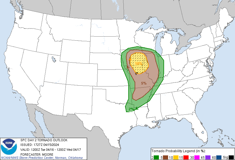
Probability of a tornado within 25 miles of a point. Hatched Area: 10% or greater probability of EF2 - EF5 tornadoes within 25 miles of a point.
Day 2 Tornado Risk
Area (sq. mi.)
Area Pop.
Some Larger Population Centers in Risk Area
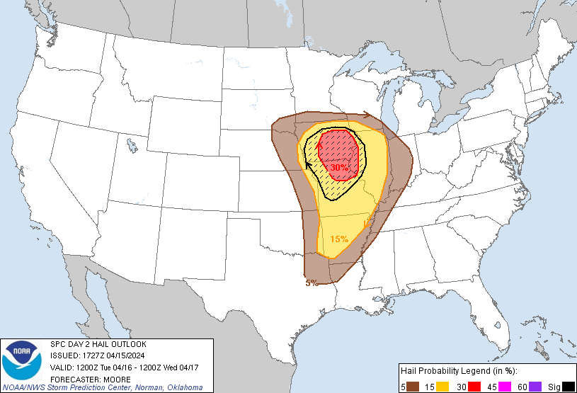
SIG SEVERE
46,296
2,796,859
Des Moines, IA...Cedar Rapids, IA...Davenport, IA...Waterloo, IA...Iowa City, IA...
10 %
46,371
2,792,010
Des Moines, IA...Cedar Rapids, IA...Davenport, IA...Waterloo, IA...Iowa City, IA...
5 %
127,793
11,018,485
St. Louis, MO...Little Rock, AR...Aurora, IL...Rockford, IL...Springfield, MO...
2 %
129,295
19,194,260
Chicago, IL...Memphis, TN...Kansas City, MO...Omaha, NE...Madison, WI...
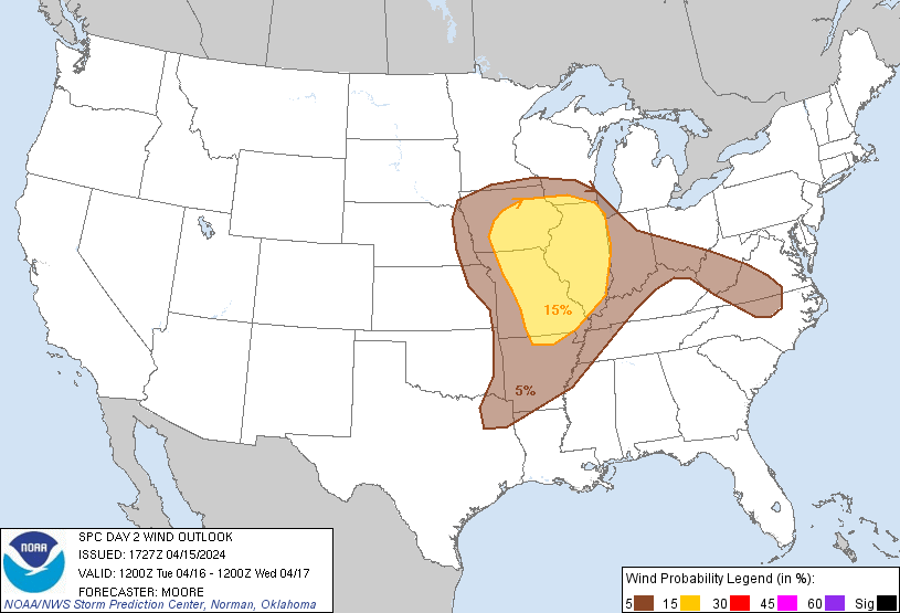
Probabilistic Damaging Wind Graphic
Probability of damaging thunderstorm winds or wind gusts of 50 knots or higher within 25 miles of a point. Hatched Area: 10% of greater probability of wind gusts 65 knots or greater within 25 miles of a point.
SPC AC 151727
Day 2 Convective Outlook
NWS Storm Prediction Center Norman OK
1227 PM CDT Mon Apr 15 2024
Valid 161200Z - 171200Z
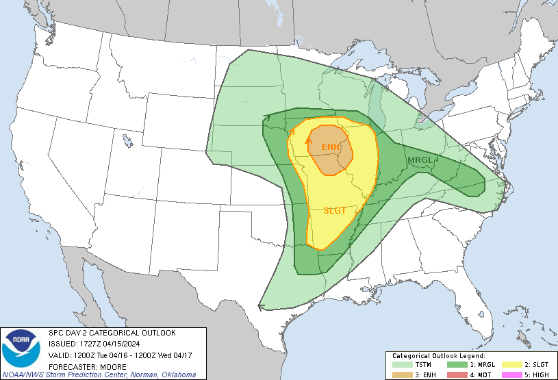
...THERE IS AN ENHANCED RISK OF SEVERE THUNDERSTORMS SOUTHEAST
IOWA...NORTHERN MISSOURI...AND WEST-CENTRAL ILLINOIS...
...SUMMARY...
Scattered severe thunderstorms are likely from Tuesday morning into
the evening across a portion of the central states from the Corn
Belt to the Ozark Plateau. The most concentrated area of significant
severe hail and tornado potential is forecast over southern Iowa
into northern Missouri and west-central Illinois. A more isolated
severe threat is anticipated across portions of the Mid-Atlantic
states.
...Synopsis...
A robust upper-level low is evident in mid-morning water-vapor
imagery over the Four Corners region. At the surface, pressure falls
are ongoing as a lee cyclone begins to consolidate across the High
Plains. Over the next 24-48 hours, this surface low is forecast to
migrate east towards the MS River Valley, likely reaching northern
IA by late afternoon/early evening as it begins to occlude.
Thunderstorms will be focused within a preceding warm advection
plume, along a leading outflow boundary associated with
early-morning convection, and along a trailing cold front. The most
intense convection is expected in the vicinity of the surface low
along the northern fringe of the warm sector where strong synoptic
ascent will overspread a buoyant air mass with favorable low-level
wind shear; however, several mesoscale details that will likely
determine the overall magnitude of the severe event will be
dependent on the intensity/coverage of early-morning convection,
which introduces uncertainty into the forecast.
...Corn Belt/Lower MO and Mid-MS Valleys...
Latest guidance continues to show reasonably good agreement in the
potential for ongoing showers and thunderstorms across eastern NE/KS
at 12 UTC Tuesday morning. This activity should intensify through
the morning across northern MO/central IA amid diurnal heating of a
moist, and weakly capped warm sector. While somewhat modest
mid-level lapse rates (6-7 C/km) will limit MLCAPE to around 1000
J/kg, strong veering flow in the lowest 2 km and 60-70 knot flow
aloft may support early supercell development with an attendant
tornado/wind threat. Low-level helicity will likely be maximized
along the surface warm/occluding front across portions of western IL
into IA, and recent CAMs continue to show a strong UH signal across
this region.
However, this potential will likely be modulated by two factors. The
first is the degree of cloud cover/stratiform precipitation on the
northern fringe of the warm sector - especially across MO/IA/IL,
which may limit the degree of low-level destabilization. The second
is storm coverage, which remains very uncertain given high spread in
recent CAMs' depiction of convective evolution over the next 24
hours. Greater thunderstorm coverage than currently anticipated at
12 UTC may complicate convective mode later in the day, and the
strong synoptic ascent in the vicinity of the surface low, coupled
with weak capping, may favor higher convective coverage. If this
occurs, northerly storm motions along the primary boundary may favor
storm interactions/consolidation into one or more clusters/lines
that may favor a severe wind risk over tornado/hail. Regardless, the
overall synoptic regime and forecast environment support maintaining
the current risk probabilities. The strong effective bulk shear
values (60-70 knots) and effective SRH near 250 m2/s2 suggest that
significant hail and/or significant tornadoes are possible if a
predominantly discrete mode can be realized. Some solutions hint at
re-development late afternoon along the cold front across northern
MO/southern IA, but confidence in this scenario is low given the
high dependence on rapid destabilization after preceding convection.
...OH Valley into the Mid-Atlantic...
Isolated to scattered thunderstorms are expected to develop by late
morning within a warm advection regime over the OH River Valley.
While buoyancy will be somewhat meager (500-1000 J/kg MLCAPE),
elongated deep-layer hodographs may support storm longevity as they
meander southeast into the Appalachians/Mid-Atlantic region. Surface
temperatures warming into the low to mid 80s will steepen low-level
lapse rates to near 8 C/km, which may support a few damaging gusts
with the stronger cells.
..Moore.. 04/15/2024
CLICK TO GET WUUS02 PTSDY2 PRODUCT
NOTE: THE NEXT DAY 2 OUTLOOK IS SCHEDULED BY 0600Z