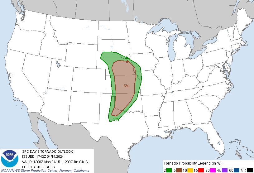
Probability of a tornado within 25 miles of a point. Hatched Area: 10% or greater probability of EF2 - EF5 tornadoes within 25 miles of a point.
Day 2 Tornado Risk
Area (sq. mi.)
Area Pop.
Some Larger Population Centers in Risk Area
5 %
124,801
5,079,722
Oklahoma City, OK...Omaha, NE...Wichita, KS...Lincoln, NE...Topeka, KS...
2 %
99,583
4,195,884
Kansas City, MO...Tulsa, OK...Overland Park, KS...Kansas City, KS...Olathe, KS...
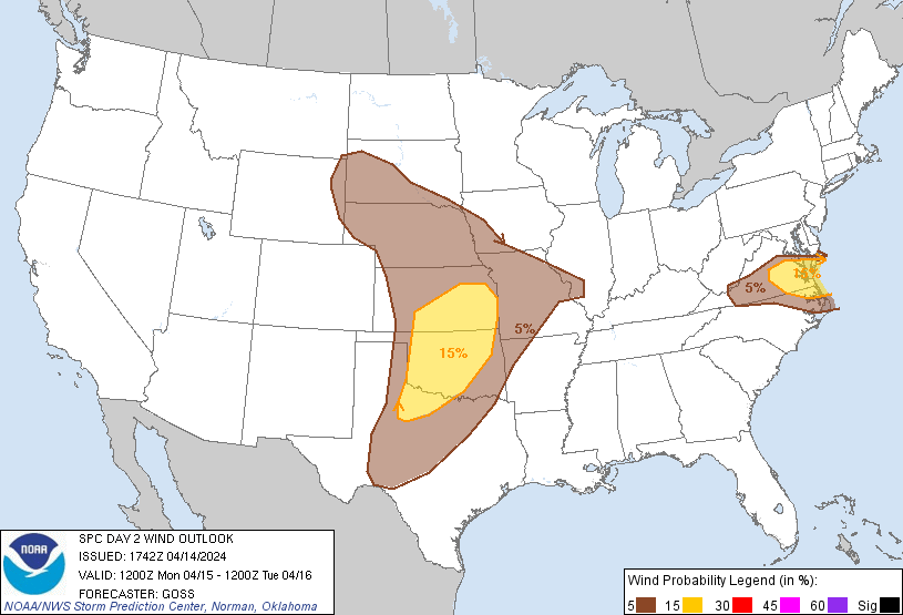
Probabilistic Damaging Wind Graphic
Probability of damaging thunderstorm winds or wind gusts of 50 knots or higher within 25 miles of a point. Hatched Area: 10% of greater probability of wind gusts 65 knots or greater within 25 miles of a point.
Day 2 Wind Risk
Area (sq. mi.)
Area Pop.
Some Larger Population Centers in Risk Area
15 %
109,171
8,231,480
Oklahoma City, OK...Virginia Beach, VA...Tulsa, OK...Wichita, KS...Norfolk, VA...
5 %
346,741
20,488,701
Dallas, TX...Fort Worth, TX...Kansas City, MO...Omaha, NE...Arlington, TX...
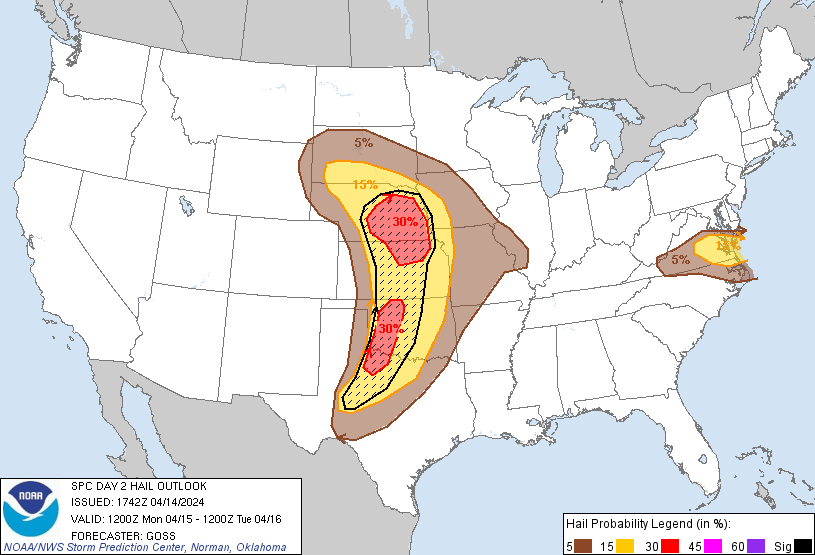
Probabilistic Large Hail Graphic
Probability of hail 1" or larger within 25 miles of a point. Hatched Area: 10% or greater probability of hail 2" or larger within 25 miles of a point.
Day 2 Hail Risk
Area (sq. mi.)
Area Pop.
Some Larger Population Centers in Risk Area
SIG SEVERE
135,482
5,398,029
Oklahoma City, OK...Omaha, NE...Wichita, KS...Lincoln, NE...Abilene, TX...
SPC AC 141742
Day 2 Convective Outlook
NWS Storm Prediction Center Norman OK
1242 PM CDT Sun Apr 14 2024
Valid 151200Z - 161200Z
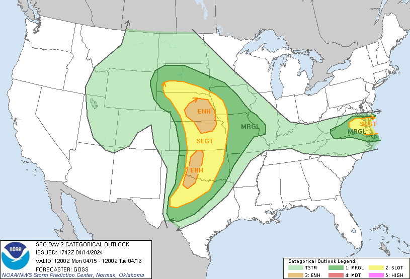
...THERE IS AN ENHANCED RISK OF SEVERE THUNDERSTORMS ACROSS PORTIONS
OF NEBRASKA AND KANSAS...AND PARTS OF WESTERN OKLAHOMA AND WESTERN
NORTH TEXAS...
...THERE IS A SLIGHT RISK OF SEVERE THUNDERSTORMS ACROSS
SOUTHEASTERN VIRGINIA AND NORTHEASTERN NORTH CAROLINA...
...SUMMARY...
Scattered severe thunderstorms are likely across the southern to
central Great Plains, mainly Monday evening and night. Large to very
large hail, damaging wind gusts, and a few tornadic storms are
possible.
...Synopsis...
An upper low over the Great Basin at the start of the period is
forecast to shift east toward -- and eventually into -- the central
Plains region through the period. As this occurs, lee cyclogenesis
will occur over the central High Plains by Monday afternoon, and
drift east along the KS/NE border through 12Z Tuesday. Low-level
moisture modification from the northwest Gulf, while sufficient for
severe storms, will not be overly rich or deep beneath a stout
elevated mixed layer. Mid 60s surface dew points should become
common over the southern Great Plains ahead of the dryline by
evening with upper 50s to low 60s reaching northward into the
central Plains.
...Central/southern Plains...
Late afternoon to early evening thunderstorm development is expected
as diurnal heating and broad large-scale ascent aids in weakening of
capping in place across much of the warm sector. Fairly widespread
development of storms is expected across the central High Plains and
arcing east-southeast along the surface warm front into the
Mid-Missouri Valley. Boundary-layer moisture will decrease with
northwest extent, but favorable deep-layer ascent within a favorably
strong/veering deep-layer flow field will support organized/rotating
storms capable of producing large hail and isolated severe wind
gusts. Given the very steep lapse rates aloft, very large hail
appears likely across parts of central and eastern Nebraska and
portions of northeastern Kansas, near and north of the surface warm
front, largely after dark as the upper low approaches.
Additionally, the possibility of a few surface-based supercells with
a tornado/wind threat in addition to large hail will be possible
with any warm-sector/surface-based storms.
A separate corridor of a few diurnal storms should form in west TX
along the dryline within the deeply mixed air. Stout capping should
limit storm coverage, but any storm which can develop would become
supercellular, with large hail and damaging wind likely. Mid-level
height falls and tropospheric flow fields will increase into Monday
night, which should result in greater convective development
overnight. Large hail and damaging winds would be possible with
this second round of storms, along with potential for a couple of
tornadoes. Given uncertainty as to where greatest storm coverage
will ultimately evolve, the ENH risk area may need to be adjusted in
later forecasts.
...VA/NC...
A weakening surface cold front should sag south in VA on Monday.
Strong heating of a modestly moist boundary layer near and just
south of the front will yield a fairly deep surface-based mixed
layer. Low-level convergence should be sufficient for isolated to
scattered thunderstorm development across southern Virginia by late
afternoon. Amply strong flow aloft is expected across the area on
the southern fringe of the stronger mid-level jet to the north.
Amid steep mid-level lapse rates, overall setup should support a few
multicell clusters of storms, capable of marginally severe hail
initially, and locally damaging wind gusts as storms spread
southeast before weakening later in the evening.
..Goss.. 04/14/2024
CLICK TO GET WUUS02 PTSDY2 PRODUCT
NOTE: THE NEXT DAY 2 OUTLOOK IS SCHEDULED BY 0600Z