Oklahoma City, OK...Kansas City, MO...Omaha, NE...Tulsa, OK...Wichita, KS...
MARGINAL
294,414
24,970,225
Dallas, TX...Fort Worth, TX...Virginia Beach, VA...Arlington, TX...Raleigh, NC...
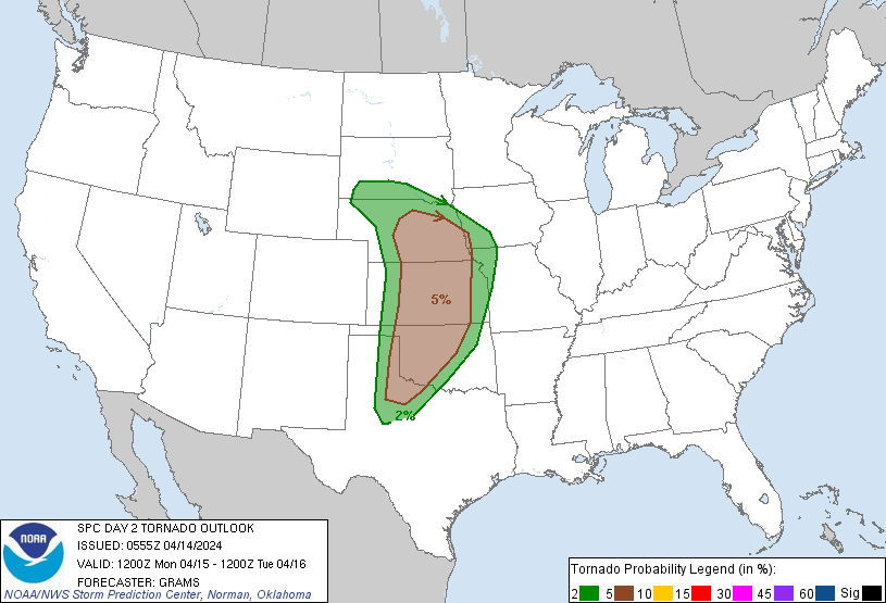
Probabilistic Tornado Graphic
Probability of a tornado within 25 miles of a point. Hatched Area: 10% or greater probability of EF2 - EF5 tornadoes within 25 miles of a point.
Day 2 Tornado Risk
Area (sq. mi.)
Area Pop.
Some Larger Population Centers in Risk Area
5 %
129,802
5,080,758
Oklahoma City, OK...Omaha, NE...Wichita, KS...Lincoln, NE...Topeka, KS...
2 %
105,769
4,353,997
Kansas City, MO...Tulsa, OK...Overland Park, KS...Kansas City, KS...Olathe, KS...
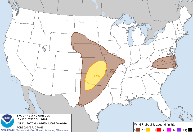
Probabilistic Damaging Wind Graphic
Probability of damaging thunderstorm winds or wind gusts of 50 knots or higher within 25 miles of a point. Hatched Area: 10% of greater probability of wind gusts 65 knots or greater within 25 miles of a point.
Day 2 Wind Risk
Area (sq. mi.)
Area Pop.
Some Larger Population Centers in Risk Area
15 %
93,003
4,862,392
Oklahoma City, OK...Tulsa, OK...Wichita, KS...Topeka, KS...Norman, OK...
5 %
389,250
27,476,008
Dallas, TX...Fort Worth, TX...Kansas City, MO...Virginia Beach, VA...Omaha, NE...
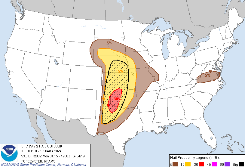
Probabilistic Large Hail Graphic
Probability of hail 1" or larger within 25 miles of a point. Hatched Area: 10% or greater probability of hail 2" or larger within 25 miles of a point.
Day 2 Hail Risk
Area (sq. mi.)
Area Pop.
Some Larger Population Centers in Risk Area
SIG SEVERE
163,122
4,725,083
Oklahoma City, OK...Wichita, KS...Lincoln, NE...Abilene, TX...Norman, OK...
SPC AC 140555
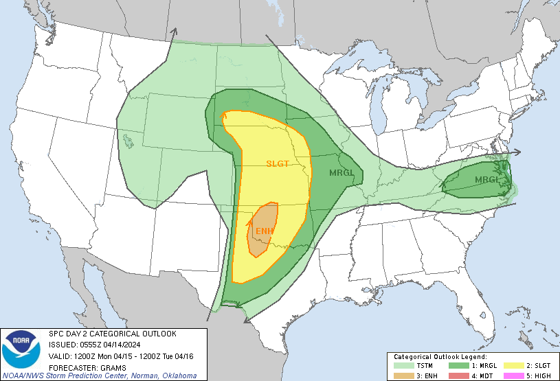
Day 2 Convective Outlook
NWS Storm Prediction Center Norman OK
1255 AM CDT Sun Apr 14 2024
Valid 151200Z - 161200Z
...THERE IS AN ENHANCED RISK OF SEVERE THUNDERSTORMS IN WESTERN OK
AND A PART OF NORTHWEST TX...
...SUMMARY...
Scattered severe thunderstorms are likely across the southern to
central Great Plains, mainly Monday evening and night. Large to very
large hail, damaging wind gusts, and a few tornadic storms are
possible.
...Central/southern Great Plains...
A shortwave trough will be centered on the southeast Great Basin at
12Z Monday. Multiple embedded impulses will eject east across the
southern Rockies and Southwest, and onto the central to southern
High Plains by early morning Tuesday. This fragmented evolution and
timing of ejection onto the southern High Plains appears ill-timed
with the peak diurnal heating cycle. The southern/more vigorous of
the impulses will yield substantial tropospheric flow amplification
as a mid-level jetlet in excess of 80 kts at 500 mb evolves across
the southern TX Panhandle into south KS Monday night.
Substantial lee cyclogenesis will occur over the central High Plains
by Monday afternoon, and drift east along the KS/NE border through
12Z Tuesday. Low-level moisture modification from the northwest
Gulf, while sufficient for severe storms, will not be overly rich or
deep beneath a stout elevated mixed layer. Mid 60s surface dew
points should become common over the southern Great Plains ahead of
the dryline by evening with low 60s to upper 50s with northern
extent in the central Great Plains.
Late afternoon to early evening thunderstorm development will
probably be bimodal, with more probable convection across the
central High Plains arcing east-southeast along the surface warm
front into the Mid-MO Valley. Boundary-layer moisture will be less
with northwest extent, but favorable deep-layer ascent within a
meridional to backed wind profile should be conducive to large hail
and isolated severe wind gusts. Along the warm front into the Mid-MO
Valley, most development should remain on the cool side of the
surface warm front amid northeast storm motions, but there will be
the possibility of a few surface-based supercells with a
tornado/wind threat in addition to large hail.
A separate corridor of a few storms should form in west TX along the
dryline within the deeply mixed air owing to a stout capping
inversion across the warm-moist sector where mid/upper-level
cloudiness should temper insolation. Mid-level height falls and
tropospheric flow fields will increase into Monday night. 00Z NCEP
guidance outside of the GFS suggest minimal to isolated convective
coverage should be expected until near the end of the period, while
the ECMWF remains consistent with earlier runs depicting
substantially greater convective development overnight. While this
lowers confidence in the degree of supercell coverage amid robust
MLCIN with southeast extent in OK/TX, have maintained level 3-ENH
risk where the conditional threat for strong supercells is greatest.
...VA/NC...
A weakening surface cold front should sag south in VA on Monday,
with a ribbon of modest boundary-layer moisture along it. Strong
insolation will occur ahead of it into NC, yielding a deeply mixed
boundary layer. Low-level convergence should be sufficient for
isolated to scattered thunderstorm development by late afternoon.
Moderate mid-level flow will be present and increase in height
within the peripheral influence of a strong jet across parts of the
Great Lakes into southern New England. Amid steep mid-level lapse
rates, overall setup should support a few multicells capable of
marginally severe hail initially, and strong to marginally severe
wind gusts as storms spread southeast before weakening after dusk.
..Grams.. 04/14/2024
CLICK TO GET WUUS02 PTSDY2 PRODUCT
NOTE: THE NEXT DAY 2 OUTLOOK IS SCHEDULED BY 1730Z