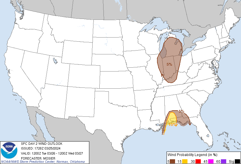
Probability of damaging thunderstorm winds or wind gusts of 50 knots or higher within 25 miles of a point. Hatched Area: 10% of greater probability of wind gusts 65 knots or greater within 25 miles of a point.
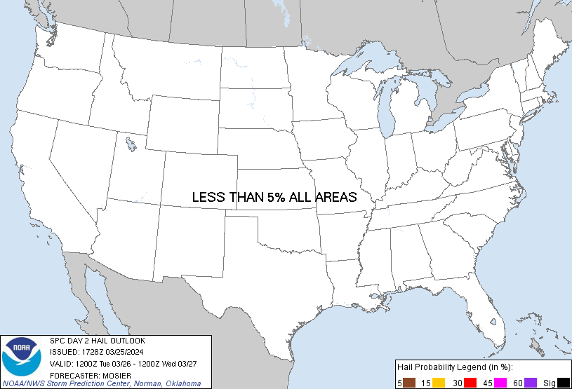
Probability of hail 1" or larger within 25 miles of a point. Hatched Area: 10% or greater probability of hail 2" or larger within 25 miles of a point.
Day 2 Hail Risk
Area (sq. mi.)
Area Pop.
Some Larger Population Centers in Risk Area
No Risk Areas Forecast
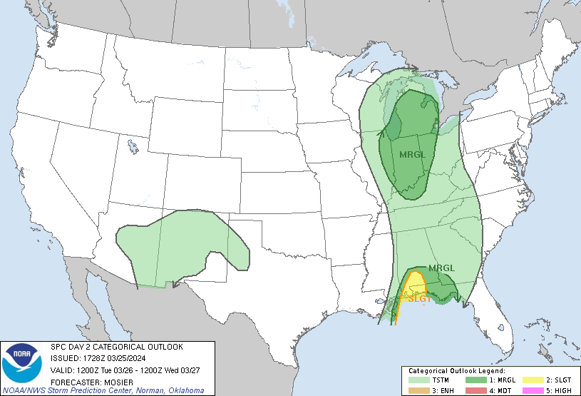
SPC AC 251728
Day 2 Convective Outlook
NWS Storm Prediction Center Norman OK
1228 PM CDT Mon Mar 25 2024
Valid 261200Z - 271200Z
...THERE IS A SLIGHT RISK OF SEVERE THUNDERSTORMS ACROSS PORTIONS OF
SOUTHERN ALABAMA AND THE WESTERN FLORIDA PANHANDLE...
...SUMMARY...
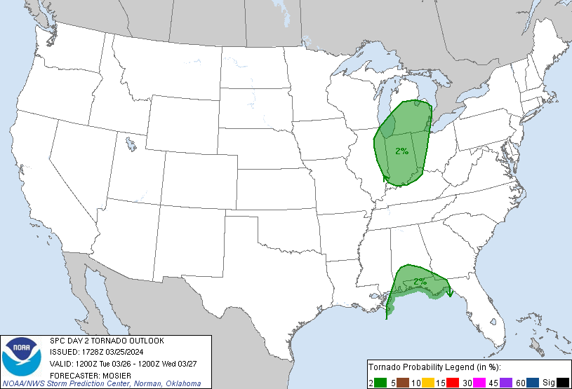
An isolated threat for damaging winds and a tornado or two may
persist Tuesday along/near the central Gulf Coast, with a separate
area of isolated strong to severe thunderstorms potentially
developing by Tuesday afternoon across parts of the Midwest and
southern Great Lakes.
...Synopsis...
Extensive upper troughing is expected to cover the majority of the
CONUS early Tuesday morning. Moderate to strong mid-level flow will
extend throughout this troughing Tuesday morning, arcing
cyclonically from the West Coast across central Mexico and the TX
Gulf Coast, and then up the MS Valley through the Upper Great Lakes.
Several shortwave troughs will be embedded within this large
troughing, with the most prominent shortwave beginning the period
over the Mid MS Valley. Expectation is for this shortwave to move
quickly northeastward into eastern Ontario by the afternoon,
accompanied by very strong mid-level flow (i.e. 100+ kt at 500 mb).
Deep surface low associated with this wave is also expected to move
northeastward from its initial position over northwest WI into
northwest Ontario. As it does, an attendant cold front will sweep
quickly eastward/northeastward across the Mid MS Valley, the Upper
Great Lakes, and the OH Valley.
Farther south, thunderstorms will likely be ongoing early Tuesday
morning along an outflow-reinforced cold front stretching from
middle TN southwestward off the AL/MS coast. Steady eastward
progression of this front is expected throughout the day, before it
stalls over GA and the eastern FL Panhandle Tuesday evening.
...Southern AL into Southeast GA and the FL Panhandle...
Ongoing convective line is expected to extend from central AL into
coastal AL and the far western FL Panhandle early Tuesday morning.
Moderate low-level moisture and buoyancy will be over southwest
AL/coastal AL and the far western FL Panhandle early Tuesday, with
some potential for damaging gusts and maybe even a brief tornado or
two as the line moves through. An isolated severe threat may persist
into Tuesday afternoon and continue through Tuesday night across
southeastern AL, southwestern GA, and the FL Panhandle vicinity as
mid to upper 60s surface dewpoints attempt to advance inland across
these areas. However, poor lapse rates aloft and limited daytime
heating from cloud cover should temper buoyancy, leading to a
gradually diminishing storm intensity.
...OH Valley/Southern Lower MI...
Clearing is anticipated in the wake of the warm conveyor and ahead
of the primary cold front across the OH Valley and southern Lower
MI, beginning during the late morning over IL. This clearing is
expected to allow temperatures to climb into the 60s. Low-level
moisture will be limited (i.e. in the low 50s), but the combination
of modest low-level moisture with temperatures in the 60s and cold
mid-level temperatures (i.e. around -20 deg C at 500 mb) is expected
to result in air mass destabilization and modest buoyancy. Shallow
thunderstorms are expected to develop along the cold front as it
interacts with this destabilized air mass, likely beginning during
the late morning across IL before then moving eastward/northeastward
throughout the day. Buoyancy will be modest, but robust low to
mid-level fields will be present and the deep-layer vertical shear
vector will oriented mostly perpendicular to the front. These
factors suggest fast-moving storms capable of damaging gusts,
particularly since the gradient surface wind will already be
enhanced. A tornado or two is also possible, although the limited
storm depth could act as a limiting factor for greater storm
organization.
..Mosier.. 03/25/2024
CLICK TO GET WUUS02 PTSDY2 PRODUCT
NOTE: THE NEXT DAY 2 OUTLOOK IS SCHEDULED BY 0600Z