Probability of damaging thunderstorm winds or wind gusts of 50 knots or higher within 25 miles of a point. Hatched Area: 10% of greater probability of wind gusts 65 knots or greater within 25 miles of a point.
Day 1 Wind Risk
Area (sq. mi.)
Area Pop.
Some Larger Population Centers in Risk Area
SIG SEVERE
136,720
13,989,553
Dallas, TX...Fort Worth, TX...Oklahoma City, OK...Kansas City, MO...Tulsa, OK...
30 %
186,733
16,420,731
Dallas, TX...Fort Worth, TX...Oklahoma City, OK...Kansas City, MO...Tulsa, OK...
SPC AC 272000
Day 1 Convective Outlook
NWS Storm Prediction Center Norman OK
0300 PM CDT Sat Apr 27 2024
Valid 272000Z - 281200Z
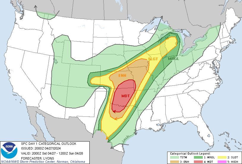
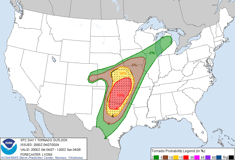
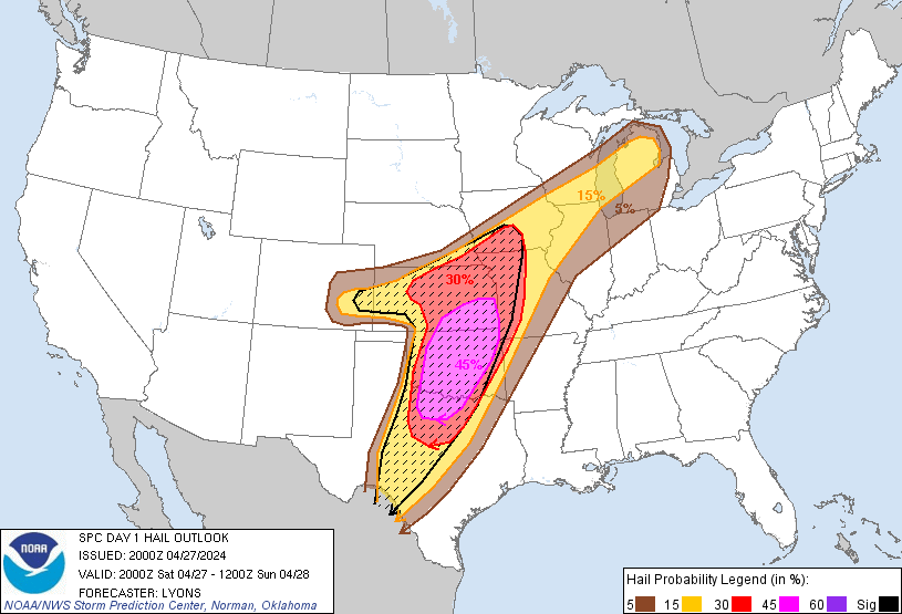
...THERE IS A MODERATE RISK OF SEVERE THUNDERSTORMS OVER PARTS OF
THE SOUTHERN AND CENTRAL PLAINS...
...SUMMARY...
Severe thunderstorms are likely today and tonight across the
southern and central Plains into the lower to mid Missouri Valley.
The most numerous/intense storms are expected from north Texas into
Oklahoma and southeast Kansas, where strong tornadoes, very large
hail of 2-3 inches in diameter and damaging winds of 60-80 mph are
all possible.
...20z Update...
The previous forecast remains on track for a regional outbreak of
severe storms with strong, potentially long-track tornadoes, very
large hail and damaging winds. Numerous storms have initiated within
the warm sector ahead of the dryline over central KS and much of OK.
Numerous supercells are present, but storm organization has been
slow thus far. As the boundary-layer slowly deepens from strong
southerly warm air advection and muted diurnal heating, an
increasingly strong low-level jet will gradually expand low-level
hodographs. Multiple rounds of convection appear likely through
tonight as the main trough is still forecast to overspread the
southern Plains from 21-06z. While some uncertainty about storm mode
and interactions limits predictability for higher tornado probs, the
environment remains favorable for strong and potentially long-track
tornadoes and very large hail with the more discrete supercells into
tonight.
...Northern KS and southern NE into MO and IA...
The cold front/effective boundary has trended farther south than the
most recent guidance. Additional storm development to the south
should further reinforce this boundary through the day. Hail and a
few tornadoes appear likely with supercells along the warm side of
the front. Have adjusted the ENH southward to better account for
ongoing storms.
Farther east, clear skies and strong low-level moisture advection
have allowed for substantial destabilization over parts of northern
MO and southern IA. South of the effective front, additional storm
development into lines and clusters appears likely into the
afternoon. Damaging winds and a few tornadoes are likely.
..Lyons.. 04/27/2024
.PREV DISCUSSION... /ISSUED 1125 AM CDT Sat Apr 27 2024/
...A regional outbreak of severe thunderstorms is forecast for this
afternoon and evening across parts of KS/OK. Very large hail and
strong tornadoes are possible..
...OK/northwest TX/south-central KS...
Water vapor imagery shows the main upper trough is still back over
southern AZ, with a rapidly ejecting mid/upper level jet streak
nosing into OK/TX. This lead feature has aided in the development
of severe storms this morning over parts of west TX/OK. Storms will
develop northeastward through the afternoon into central KS, despite
an expansive anvil shield from the morning convection. These storms
will pose a risk of very large hail and a few tornadoes through the
afternoon and early evening.
Farther south, the air mass across much of central/western OK and
northwest TX continues to warm/destabilize as temperatures rise
through the mid/upper 70s - eliminating CINH. Only weak upper
forcing through the afternoon will result in chaotic development of
discrete supercells in a very strongly sheared and very unstable
environment. Forecast soundings show very steep mid-level lapse
rates, ample low-level moisture, and strong/increasing shear
profiles through the day. Details of timing and location are
nebulous, but those storms that develop will pose a risk of very
large hail and strong and possibly long-track tornadoes. The
stronger large-scale forcing will arrive around/after dark, with a
greater eastward surge of storms across central OK expected. This
activity may organize upscale in bowing segments will an increasing
risk of damaging winds along with hail and tornadoes into southeast
KS and northeast OK tonight.
...Southeast CO into northern KS...
A rather strong surface boundary extends from southeast CO across
much of northern KS. Relatively strong heating along this boundary
and moderate instability will lead to scattered thunderstorm
development by mid-afternoon along the entire corridor. Steep
mid-level lapse rates, strong deep-layer shear, and favorable
low-level wind profiles in vicinity of the boundary will pose a risk
of very large hail and a few tornadoes through the afternoon and
early evening. This activity is expected to build eastward this
evening along the same boundary into parts of southern IA/northern
MO, with a continued risk of large hail along with an increasing
threat of damaging winds.
CLICK TO GET WUUS01 PTSDY1 PRODUCT
NOTE: THE NEXT DAY 1 OUTLOOK IS SCHEDULED BY 0100Z