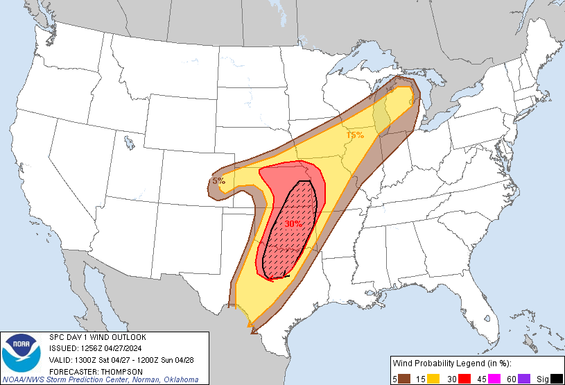
Probability of damaging thunderstorm winds or wind gusts of 50 knots or higher within 25 miles of a point. Hatched Area: 10% of greater probability of wind gusts 65 knots or greater within 25 miles of a point.
Day 1 Wind Risk
Area (sq. mi.)
Area Pop.
Some Larger Population Centers in Risk Area
SIG SEVERE
83,243
10,949,742
Dallas, TX...Fort Worth, TX...Oklahoma City, OK...Tulsa, OK...Arlington, TX...
30 %
147,139
15,283,396
Dallas, TX...Fort Worth, TX...Oklahoma City, OK...Kansas City, MO...Tulsa, OK...
SPC AC 271256
Day 1 Convective Outlook
NWS Storm Prediction Center Norman OK
0756 AM CDT Sat Apr 27 2024
Valid 271300Z - 281200Z
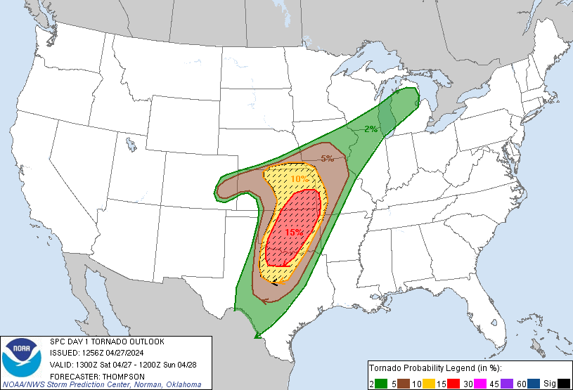
...THERE IS A MODERATE RISK OF SEVERE THUNDERSTORMS THROUGH TONIGHT
FOR OK...NORTH TX...SOUTHEAST KS AND EXTREME SOUTHWEST MO...
...SUMMARY...
Severe thunderstorms are likely today and tonight across the
southern and central Plains into the lower to mid Missouri Valley.
The most numerous/intense storms are expected from north Texas into
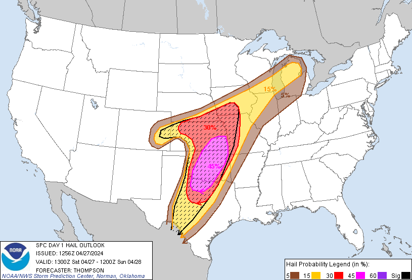
Oklahoma and southeast Kansas, where strong tornadoes, very large
hail of 2-3 inches in diameter and damaging winds of 60-70 mph are
all possible.
...A regional severe-weather outbreak is expected from north TX
across OK into KS with strong tornadoes, very large hail and
damaging winds all part of a long-duration threat...
...OK/KS/north TX through tonight...
A pronounced midlevel trough over the Four Corners will move
eastward today and then begin to eject northeastward tonight over
the central/southern High Plains. This synoptic pattern will
maintain a lee cyclone in southeast CO and a dryline arcing
southeastward and then southward close to the western OK border.
Farther north, a stalling baroclinic zone will move slowly northward
into northern KS today and central IA by this evening.
A broad, unstable warm sector with boundary-layer dewpoints of 65-70
F will support multiple rounds of severe/tornadic storms through the
period, both along the synoptic boundaries and in parts of the open
warm sector for OK/KS.
The initial severe/tornado threat has already begun near Caprock
from Lubbock to Childress as an embedded jet streak (evident as the
fast-moving cloud streak over west TX) begins to interact with the
northwest edge of the richer low-level moisture. Despite the
unusually early start, there will be the potential for embedded
supercells capable of all hazards as the storms overspread
western/northern OK into southern KS through midday. An outflow
boundary and/or differential heating corridor is likely in the
immediate wake of these morning storms from southern KS into north
central and southwest OK. Additional thunderstorm development is
likely by early-mid afternoon along this zone and the dryline to the
south into TX, and storms will spread generally northeastward toward
southern/central OK and southeast KS. A moist boundary layer,
MLCAPE of 2500-3500 J/kg and lengthening/enlarging hodographs with
time (as a mass response to the approaching shortwave trough) will
become more favorable for tornadic supercells, including the
potential for long-track EF2-EF3+ tornadoes. The significant
tornado threat will be greatest if semi-discrete supercells can be
maintained well into the afternoon/evening. Very large hail up to 3
inches in diameter can also be expected with the more intense
supercells.
The storm evolution has the potential to be a bit messy with
multiple training/conjoined supercells, posing a relatively
long-duration and repeat threat to areas within the training storm
corridors across the central third of OK. Damaging winds will
become more probable with storm clustering, and there will likely be
upscale growth into a larger QLCS this evening into tonight as the
primary shortwave trough approaches from the west. The potential
for tornadoes with embedded circulation will continue into the
overnight hours, along with damaging winds.
...East central CO/far western KS this afternoon/evening...
Near the lee cyclone and a stalled front, thunderstorm development
is expected by early afternoon in a small cluster/arc across east
central CO. Despite boundary-layer dewpoints only in the 40s, cold
midlevel temperatures and steep lapse rates will contribute to
surface-based CAPE up to 1000 J/kg. Relatively large, curved
hodographs will favor supercells capable of producing a few
tornadoes and large hail, as well as damaging gusts once any upscale
growth into a line segment occurs.
...Northern IL/southeast WI/Lower MI this afternoon/evening...
A midlevel trough and associated surface cyclone will move
northeastward today from the upper MS Valley to the upper Great
Lakes. The stronger forcing for ascent has already moved northeast
of the surface warm sector, so storm development in this corridor
will likely be later this afternoon/evening in association with
low-level ascent along the stalling front across WI/lower MI. A
band of storms is expected along the front, and other convection
could eventually spread into northern IL from eastern IA. Forecast
profiles along and south of the front show sufficient hodograph
length/deep-layer shear for organized line segments and some
embedded supercells capable of producing damaging gusts and possibly
a tornado or two. Isolated large hail will also be possible, given
some potential for embedded supercells within the northeast extent
of the 7-8 C/km midlevel lapse rates.
..Thompson/Hart.. 04/27/2024
CLICK TO GET WUUS01 PTSDY1 PRODUCT
NOTE: THE NEXT DAY 1 OUTLOOK IS SCHEDULED BY 1630Z