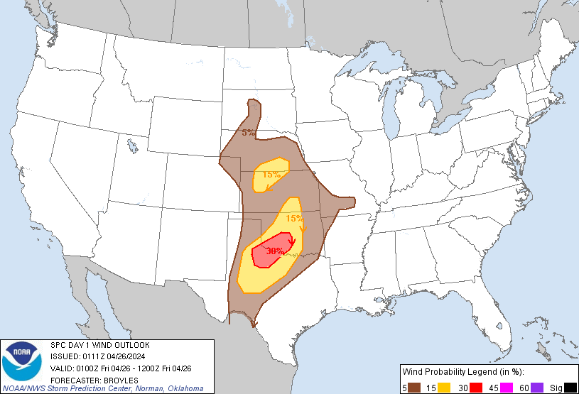
Probability of damaging thunderstorm winds or wind gusts of 50 knots or higher within 25 miles of a point. Hatched Area: 10% of greater probability of wind gusts 65 knots or greater within 25 miles of a point.
Day 1 Wind Risk
Area (sq. mi.)
Area Pop.
Some Larger Population Centers in Risk Area
30 %
22,030
1,177,932
Oklahoma City, OK...Norman, OK...Wichita Falls, TX...Lawton, OK...Moore, OK...
15 %
91,367
2,955,034
Wichita, KS...Abilene, TX...San Angelo, TX...Edmond, OK...Midwest City, OK...
5 %
243,887
14,427,442
Dallas, TX...Fort Worth, TX...Kansas City, MO...Tulsa, OK...Arlington, TX...
Probabilistic Large Hail Graphic
Probability of hail 1" or larger within 25 miles of a point. Hatched Area: 10% or greater probability of hail 2" or larger within 25 miles of a point.
Day 1 Hail Risk
Area (sq. mi.)
Area Pop.
Some Larger Population Centers in Risk Area
SIG SEVERE
66,672
867,180
Wichita Falls, TX...Lawton, OK...Garden City, KS...Dodge City, KS...Big Spring, TX...
30 %
24,630
1,174,508
Oklahoma City, OK...Norman, OK...Wichita Falls, TX...Lawton, OK...Moore, OK...
SPC AC 260111
Day 1 Convective Outlook
NWS Storm Prediction Center Norman OK
0811 PM CDT Thu Apr 25 2024
Valid 260100Z - 261200Z
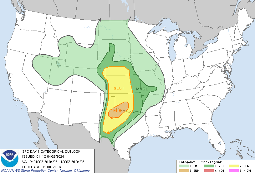
...THERE IS AN ENHANCED RISK OF SEVERE THUNDERSTORMS FROM PARTS OF
NORTHWEST TEXAS INTO SOUTHWEST OKLAHOMA...
...SUMMARY...
Large hail, a couple tornadoes, and wind damage will be possible
this evening across parts of northwestern, north-central and central
Kansas this evening. Very large hail over 2 inches in diameter,
damaging winds to 70 mph, and a few tornadoes will be possible this
evening and tonight from northwest Texas into central Oklahoma.
...Central Plains...
An upper-level low, evident on water-vapor imagery, is currently
near the Four Corners. This exit region of an associated 60 to 70
knot mid-level jet is moving through western Kansas. At the surface,
a 991 mb low is located across eastern Colorado. A dryline extends
southward from the low near the Kansas-Colorado state line. A slow
moving front is located across west-central and south-central
Kansas. A cluster of severe thunderstorms is located near and to the
north of the front across northwest Kansas. These storms will
continue to move northeastward across the remainder of northwestern
Kansas and into southern Nebraska this evening. Some storms are
expected to develop across west-central Kansas later this evening,
moving into parts of central and northern Kansas overnight.
RAP forecast soundings early this evening across northwest and
north-central Kansas have MUCAPE in the 2500 to 3000 J/kg range,
effective shear near 50 knots and 700-500 mb lapse rates in the 8.5
to 9.0 C/km range. This environment will be very favorable for
supercells with large hail. The strongest of supercells could
produce hailstones greater than 2 inches in diameter. The greatest
tornado threat is expected to be across west-central Kansas, where
forecast soundings have looped hodographs with 0-3 km storm-relative
helicity in the 400 to 500 m2/s2 range. If a discrete supercell can
re-develop across northwest or north-central Kansas later this
evening, then a tornado or two would be possible. A wind-damage
threat is also expected from west-central Kansas northeastward into
northern Kansas and southern Nebraska, where linear MCS development
will be possible later this evening.
...Southern Plains...
Water-vapor imagery currently shows a mid-level trough over the
Desert Southwest and northern Mexico. A associated mid-level jet is
moving through west Texas, where a dryline is located. To the east
of the dryline, surface dewpoints are in the 60s F and MLCAPE is
estimated by the RAP in the 2000 to 3000 J/kg range. Thunderstorms
are forecast to develop late this evening on the Caprock of west
Texas, within the right entrance region of the mid-level jet. These
storms are expected to organize into a severe storm cluster, moving
northeastward across northwest Texas and into southwest Oklahoma
tonight. Additional storms may develop further south across parts of
the west-central Texas.
RAP forecast soundings after midnight across northwest Texas and
southwest Oklahoma have MLCAPE near 3000 J/kg, with 0-6 km shear
around 40 knots, and 700-500 mb lapse rates in the 8 to 8.5 C/km
range. This will be very favorable for supercells with large hail.
Hailstones of up to 3 inches in diameter will be possible with the
strongest of supercells. In addition, forecast soundings have looped
hodographs with 0-3 km storm-relative helicity around 400 m2/s2,
suggesting that a tornado threat will develop. Wind damage will be
possible, with the threat becoming maximized if a short line segment
can eventually organize.
..Broyles.. 04/26/2024
CLICK TO GET WUUS01 PTSDY1 PRODUCT
NOTE: THE NEXT DAY 1 OUTLOOK IS SCHEDULED BY 0600Z