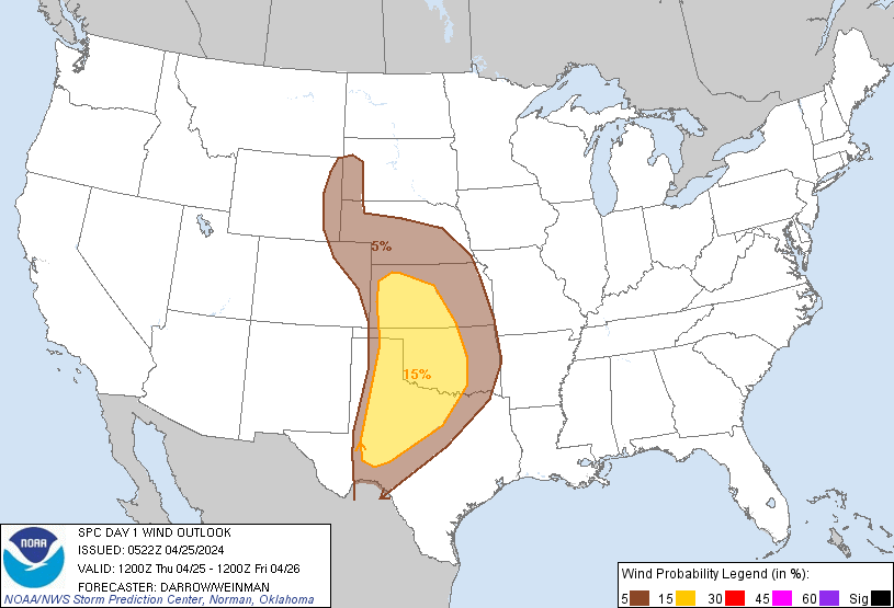
Probability of damaging thunderstorm winds or wind gusts of 50 knots or higher within 25 miles of a point. Hatched Area: 10% of greater probability of wind gusts 65 knots or greater within 25 miles of a point.
Day 1 Wind Risk
Area (sq. mi.)
Area Pop.
Some Larger Population Centers in Risk Area
15 %
147,715
4,675,468
Oklahoma City, OK...Wichita, KS...Lubbock, TX...Abilene, TX...Norman, OK...
SPC AC 250522
Day 1 Convective Outlook
NWS Storm Prediction Center Norman OK
1222 AM CDT Thu Apr 25 2024
Valid 251200Z - 261200Z
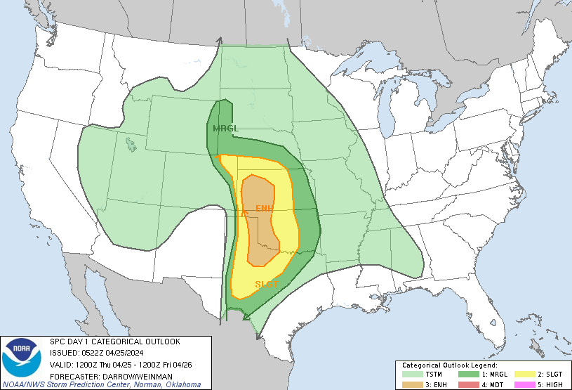
...THERE IS AN ENHANCED RISK OF SEVERE THUNDERSTORMS ACROSS PORTIONS
OF THE CENTRAL AND SOUTHERN GREAT PLAINS...
...SUMMARY...
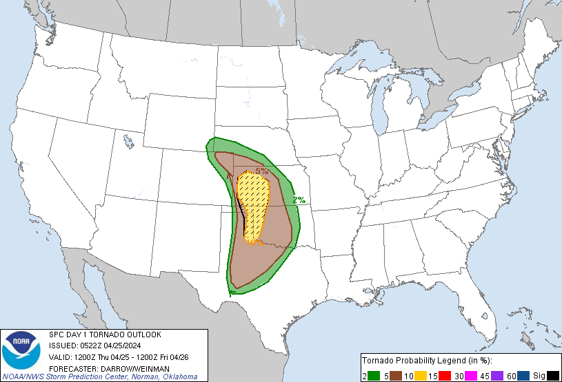
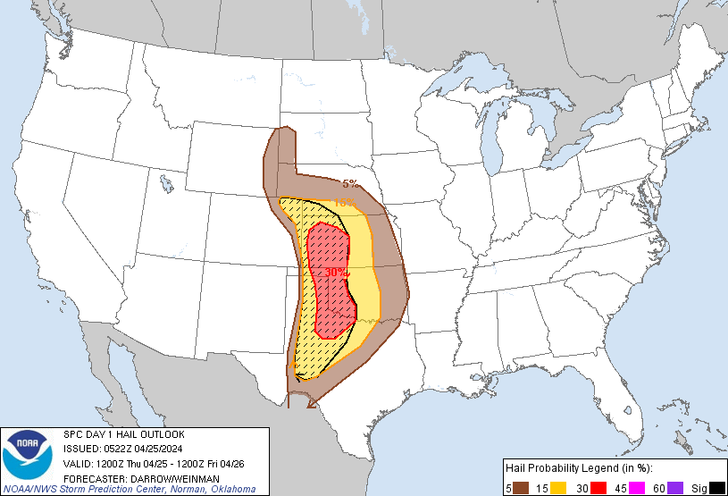
Scattered severe thunderstorms are expected from late this afternoon
into tonight across parts of the central and southern Great Plains.
Very large hail, severe wind gusts, and a couple strong tornadoes
will all be possible.
...Great Plains...
Water-vapor imagery depicts a well-defined short-wave trough off the
southern CA/Baja Peninsula Coast. 70+kt 500mb speed max is forecast
to translate across the northern Gulf of CA early in the period
before advancing into the southern high Plains at 26/00z, and
central KS by sunrise Friday. In response to this feature, lee
surface low will reposition itself into eastern CO by late
afternoon. While LLJ won't be particularly strong through 26/00z,
boundary layer will moisten significantly across the central High
Plains into northeast CO prior to the approaching jet. Surface
temperatures will warm rapidly across eastern CO such that
convective temperatures will be breached by 21z, favorably timed
with the left exit region of the jet. 60F surface dew points have
spread into the northeast TX Panhandle early this morning, and
should advance into northwest KS prior to expected supercell
initiation. Model forecast soundings exhibit favorable
shear/buoyancy for organized rotating updrafts and the dry line will
be the primary focus for initiation. Very large hail is expected
with this activity along with tornadoes, a few potentially strong.
LLJ will strengthen along the I35 corridor from north TX into NE
during the overnight hours. There will be some propensity for the
western KS convection to spread/develop downstream as low-level warm
advection increases during the latter half of the period.
Farther south along the dry line, it appears a secondary, bimodal
corridor of convection will evolve over west/northwest TX during the
late-evening hours. Deep convection may initially struggle to evolve
along the dry line as some inhibition should linger beyond sunset.
However, large-scale height falls will influence this region by late
evening and profiles will adjust. Thunderstorms are expected to
develop shortly thereafter with initial activity being supercellular
in nature. With time, upscale growth may lead to an MCS-type cluster
that should track northeast across the southern Plains. Very large
hail is possible with the early development, but a transition to
more wind could occur late. Additionally, some tornado risk will
continue overnight despite lifted parcels likely becoming somewhat
elevated.
..Darrow/Weinman.. 04/25/2024
CLICK TO GET WUUS01 PTSDY1 PRODUCT
NOTE: THE NEXT DAY 1 OUTLOOK IS SCHEDULED BY 1300Z