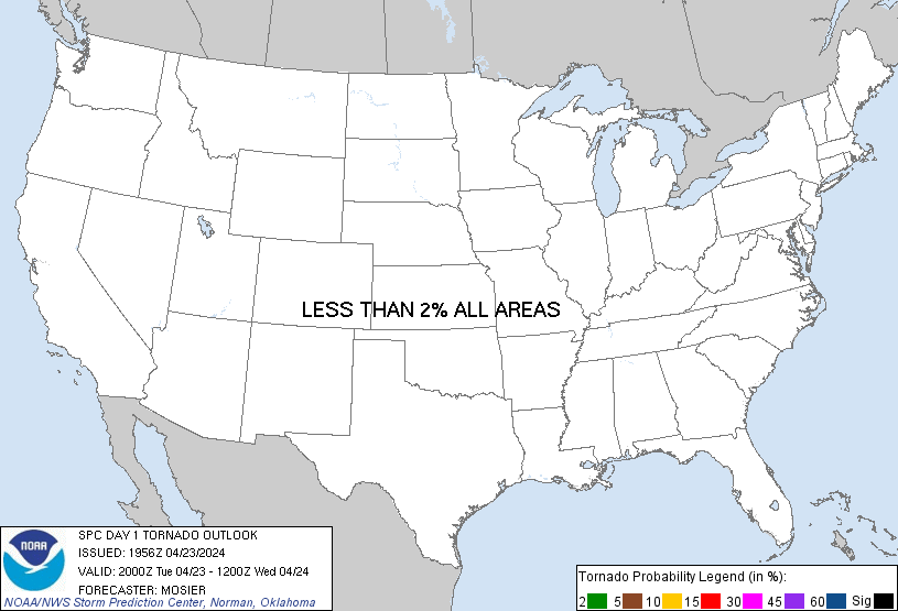
Probability of a tornado within 25 miles of a point. Hatched Area: 10% or greater probability of EF2 - EF5 tornadoes within 25 miles of a point.
Day 1 Tornado Risk
Area (sq. mi.)
Area Pop.
Some Larger Population Centers in Risk Area
No Risk Areas Forecast
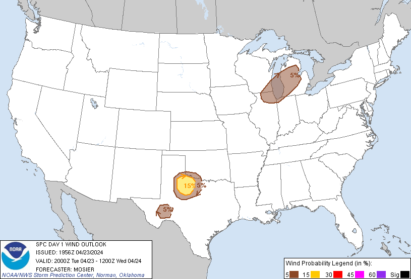
Probabilistic Damaging Wind Graphic
Probability of damaging thunderstorm winds or wind gusts of 50 knots or higher within 25 miles of a point. Hatched Area: 10% of greater probability of wind gusts 65 knots or greater within 25 miles of a point.
SPC AC 231956
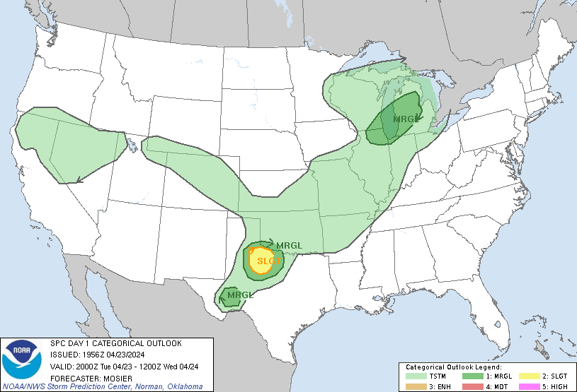
Day 1 Convective Outlook
NWS Storm Prediction Center Norman OK
0256 PM CDT Tue Apr 23 2024
Valid 232000Z - 241200Z
...THERE IS A SLIGHT RISK OF SEVERE THUNDERSTORMS ACROSS NORTHWEST
TEXAS...
...SUMMARY...
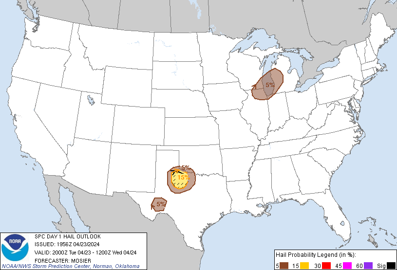
Isolated severe thunderstorms capable of producing large hail
(potentially 2+ inch diameter) and gusts to 65 mph will be possible
this afternoon and evening across northwest Texas.
...20Z Update...
Overall forecast outlined in the previous discussion (appended
below) remains valid. As mentioned in recently issued MCD 506, a
supercell or two should develop across a portion of western North
Texas through late afternoon, with large hail of 1.5 to 2.5 inches
in diameter and localized severe gusts of 60-70 mph possible. An
isolated storm or two is also possible farther south in the Texas
Trans Pecos vicinity. Marginally severe hail (i.e. around 1" in
diameter) and damaging gusts are possible here as well.
Farther north, isolated thunderstorms are still anticipated from
northern IL into Lower MI ahead of an approaching shortwave trough
and associated cold front. A few strong to severe storms are
possible with small to marginally severe hail and damaging winds as
the primary hazards (as mentioned in recently issued MCD 507).
...Early tomorrow morning from TX Panhandle into
north-central/central OK...
Elevated thunderstorms may develop from the northeast TX/eastern OK
Panhandles into central/north-central OK within the warm-air
advection regime along the northeastern edge of the returning
low-level moisture. Steep mid-level lapse rates and favorable
cloud-bearing layer shear could support an isolated instance or two
of hail with initial development. However, severe coverage is
currently expected to remain less than 5%, precluding the
introduction of any outlook areas.
..Mosier.. 04/23/2024
.PREV DISCUSSION... /ISSUED 1123 AM CDT Tue Apr 23 2024/
...Northwest TX...
Visible satellite imagery and surface analysis this morning indicate
the initial stage of moisture return is occurring across the
southern Great Plains in the wake of a frontal intrusion into the
Gulf a few days ago. A mid-level ridge will increasingly become
established across the central/southern Rockies and adjacent High
Plains as a Great Lakes disturbance gradually becomes more displaced
from the region. An associated cold front will move southward
across KS/OK before eventually stalling tonight across southeast OK
and northwest TX. Weak lee cyclogenesis will aid in maintaining a
southerly low-level fetch across central into west TX as strong
heating results in a sharpening dryline by late afternoon. Isolated
thunderstorm development will be most probable near the triple point
20-22Z. Steep lapse rates coupled with adequate moisture (1500-2000
J/kg MLCAPE) and veering flow beneath moderate westerlies, will
support an initial supercell mode. Isolated very large hail of
2-2.5 inches in diameter will be the main threat, along with a few
55-65 mph gusts.
...Northern IL/southeast WI/Lower MI late this afternoon/evening...
Have not changed the existing outlook for this region due primarily
to consistency in model data and the forecast conceptual model not
deviating. Water-vapor imagery this morning shows a mid-level
trough over the Upper Midwest and this will continue southeast into
the central Great Lakes by mid evening. An associated surface
trough will likewise move southeastward, and this trough will be
preceded by a band of rain with minimal buoyancy. Behind the rain
band, surface heating with steepening low-level lapse rates and
cooling midlevel temperatures will support weak surface-based
buoyancy just ahead of a secondary frontal surge. Some low-topped
convection will be possible late this afternoon through late evening
from northern IL/southeast WI into Lower MI. The stronger storms
could yield a localized marginal hail/damaging wind threat.
CLICK TO GET WUUS01 PTSDY1 PRODUCT
NOTE: THE NEXT DAY 1 OUTLOOK IS SCHEDULED BY 0100Z