Jacksonville, FL...Gainesville, FL...Lakeside, FL...Palm Valley, FL...Jacksonville Beach, FL...
Probabilistic Tornado Graphic
Probability of a tornado within 25 miles of a point. Hatched Area: 10% or greater probability of EF2 - EF5 tornadoes within 25 miles of a point.
Day 1 Tornado Risk
Area (sq. mi.)
Area Pop.
Some Larger Population Centers in Risk Area
No Risk Areas Forecast
Probabilistic Damaging Wind Graphic
Probability of damaging thunderstorm winds or wind gusts of 50 knots or higher within 25 miles of a point. Hatched Area: 10% of greater probability of wind gusts 65 knots or greater within 25 miles of a point.
Day 1 Wind Risk
Area (sq. mi.)
Area Pop.
Some Larger Population Centers in Risk Area
5 %
21,101
2,519,174
Jacksonville, FL...Gainesville, FL...Lakeside, FL...Palm Valley, FL...Jacksonville Beach, FL...
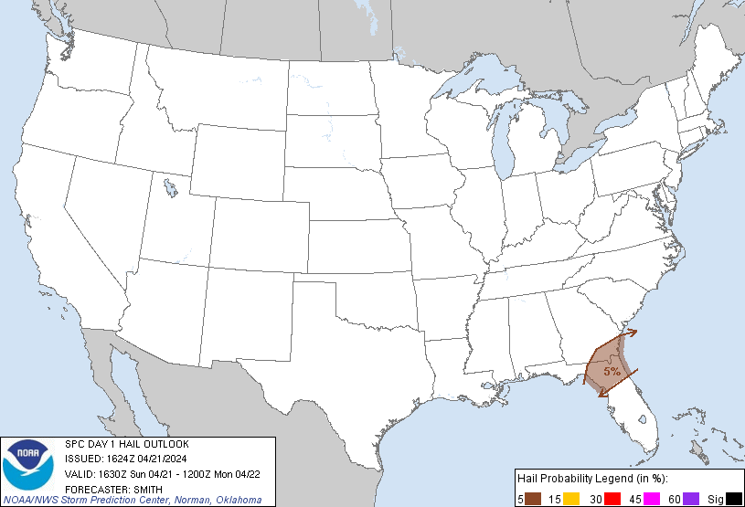
Probabilistic Large Hail Graphic
Probability of hail 1" or larger within 25 miles of a point. Hatched Area: 10% or greater probability of hail 2" or larger within 25 miles of a point.
Day 1 Hail Risk
Area (sq. mi.)
Area Pop.
Some Larger Population Centers in Risk Area
5 %
21,051
2,506,177
Jacksonville, FL...Gainesville, FL...Lakeside, FL...Palm Valley, FL...Jacksonville Beach, FL...
SPC AC 211624
Day 1 Convective Outlook
NWS Storm Prediction Center Norman OK
1124 AM CDT Sun Apr 21 2024
Valid 211630Z - 221200Z
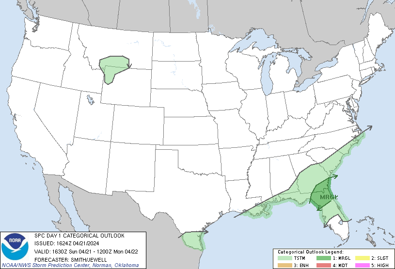
...THERE IS A MARGINAL RISK OF SEVERE THUNDERSTORMS ACROSS NORTH
FLORIDA AND SOUTH GEORGIA...
...SUMMARY...
Isolated damaging gusts and marginally severe hail will be possible
for a few hours this afternoon/evening across south Georgia and
north Florida.
...North FL/south GA this afternoon/evening...
Visible satellite imagery late this morning shows a cumulus field
and a destabilizing airmass to the east of an ongoing band of
convection near a southwest-northeast oriented front. Ample heating
over the area to the east of patchy cirrus will promote temperatures
warming into the lower 80s deg F. 12z model guidance so far has a
negative bias on surface dewpoints across north FL compared to
observations (3-6 deg F too dry). This is partially explained by a
richer moist profile observed through almost 850 mb via the 12z
Tallahassee raob. As a result, slightly higher dewpoints (upper 60s
deg F) and greater buoyancy (1000-1500 J/kg MLCAPE) are expected
than previously forecast. Water-vapor imagery shows a lead
disturbance moving east across the central Gulf Coast, and it will
reach the northeast Gulf by late this afternoon/early evening.
Ascent and some strengthening in flow will aid in some storm
organization (reference 50-kt 2-6 km flow at Tallahassee on the 88D
VAD). Limited low-level convergence and a warm layer near 800 mb
may act to hinder an otherwise more organized potential severe
setup. Regardless, isolated 50-65 mph gusts and marginally severe
hail are possible with the stronger storms this afternoon into the
early evening.
..Smith/Jewell.. 04/21/2024
CLICK TO GET WUUS01 PTSDY1 PRODUCT
NOTE: THE NEXT DAY 1 OUTLOOK IS SCHEDULED BY 2000Z