Probability of a tornado within 25 miles of a point. Hatched Area: 10% or greater probability of EF2 - EF5 tornadoes within 25 miles of a point.
Day 1 Tornado Risk
Area (sq. mi.)
Area Pop.
Some Larger Population Centers in Risk Area
No Risk Areas Forecast
Probabilistic Damaging Wind Graphic
Probability of damaging thunderstorm winds or wind gusts of 50 knots or higher within 25 miles of a point. Hatched Area: 10% of greater probability of wind gusts 65 knots or greater within 25 miles of a point.
SPC AC 190545
Day 1 Convective Outlook
NWS Storm Prediction Center Norman OK
1245 AM CDT Fri Apr 19 2024
Valid 191200Z - 201200Z
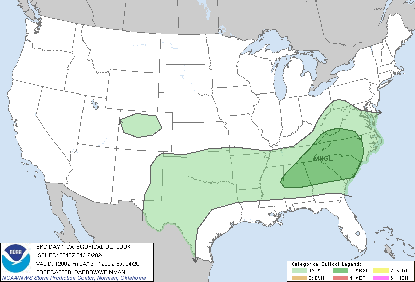
...THERE IS A MARGINAL RISK OF SEVERE THUNDERSTORMS ACROSS PORTIONS
OF THE SOUTHEASTERN US...
...SUMMARY...
Sporadic strong to marginally severe storms are possible over parts
of the Southeast later today.
...Southeast...
Strong upper trough is forecast to advance from the upper MS Valley
into ON/MI by the end of the period as a 500mb speed max translates
from southern MN into the northern OH Valley. This evolution will
necessitate substantial height falls downstream across southeastern
Canada, extending into the upper OH Valley late. Southern extent of
this forcing will only glance the middle Appalachians and lower
latitudes will remain free of significant large-scale forcing
through Saturday morning. As a result, boundary-layer heating will
prove instrumental for convective development. While weak frontal
convergence and topographic influences will also prove beneficial,
convection is not expected to appreciably develop/intensify until
surface readings approach convective temperatures. Latest model
guidance suggests much of the southern Appalachians into coastal SC
will warm rapidly today. Negligible inhibition will be noted across
this region by early afternoon and isolated-scattered convection is
expected to develop near the frontal zone, across higher elevations
of the Appalachians. This activity will propagate toward the
Piedmont before weakening with loss of daytime heating.
...TX...
Surface front has progressed into the Arklatex, arcing across
central TX into extreme northern Mexico, northwest of DRT. This
boundary will likely advance farther southwest into the higher
terrain of northern Mexico where it will stall along the northeast
slopes of the Sierra Madre Oriental range. The primary corridor of
low-level convergence will be within upslope regions of the higher
terrain west of the international border. While the boundary layer
east of the Sierra Madre should remain a bit stable, convection will
develop across the highest slopes then propagate southeast toward
the lower Rio Grande Valley. It's not entirely clear whether this
activity will maintain intensity as it spreads toward TX. At this
time will not introduce severe probabilities but this area may
warrant a MRGL risk in later outlooks if conditions become more
favorable.
Farther north during the overnight hours, weak low-level warm
advection will focus along a corridor from northwest TX into the Red
River region. Elevated convection is expected to develop across this
region as 850mb parcels are expected to be favorably moist/buoyant
for thunderstorm development. Given the lack of meaningful
large-scale forcing, there is some concern that updrafts may not be
as robust as otherwise possible. While some hail could be generated
with this activity, overall severe threat appears a bit too low to
warrant severe probabilities at this time.
..Darrow/Weinman.. 04/19/2024
CLICK TO GET WUUS01 PTSDY1 PRODUCT
NOTE: THE NEXT DAY 1 OUTLOOK IS SCHEDULED BY 1300Z