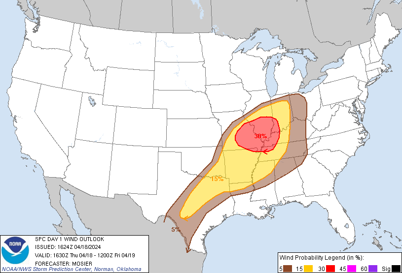
Probability of damaging thunderstorm winds or wind gusts of 50 knots or higher within 25 miles of a point. Hatched Area: 10% of greater probability of wind gusts 65 knots or greater within 25 miles of a point.
Day 1 Wind Risk
Area (sq. mi.)
Area Pop.
Some Larger Population Centers in Risk Area
30 %
64,082
5,763,815
St. Louis, MO...Evansville, IN...St. Charles, MO...Owensboro, KY...St. Peters, MO...
San Antonio, TX...Indianapolis, IN...Austin, TX...Nashville, TN...Louisville, KY...
SPC AC 181624
Day 1 Convective Outlook
NWS Storm Prediction Center Norman OK
1124 AM CDT Thu Apr 18 2024
Valid 181630Z - 191200Z
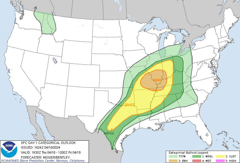
...THERE IS AN ENHANCED RISK OF SEVERE THUNDERSTORMS MAINLY THIS
AFTERNOON INTO EARLY TONIGHT FOR PARTS OF THE MID MS AND LOWER OH
VALLEYS...
...SUMMARY...
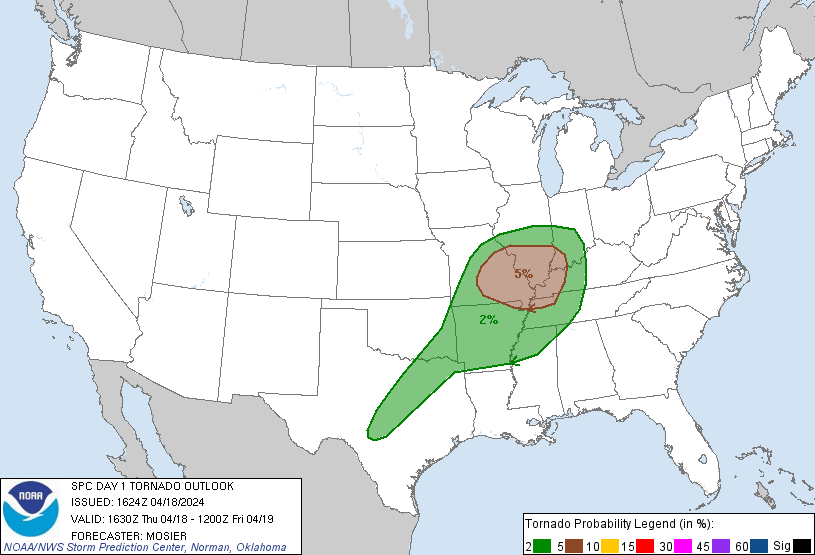
Damaging gusts to 70 mph, large hail up to 2 inches in diameter, and
a couple of tornadoes are expected mainly this afternoon into early
tonight across the middle Mississippi and lower Ohio Valleys. More
isolated large hail and damaging winds will be possible farther
south from northern Mississippi and Arkansas into central Texas.
...Mid MS/lower OH Valleys through tonight...
Recent surface analysis places a low just south of MCI along the
KS/MO border vicinity. A warm front extends eastward from this low
across central MO, far southern IL and into KY. Airmass south of
this warm front is moderately moist, with observations sampling mid
60s dewpoints along much of the AR/MO border, with some upper 60s
farther east over the MO Bootheel. Expectation is for this moist
airmass to continue progressing northward throughout the day, likely
reaching the I-70 corridor by the mid-afternoon. A cold front also
extends southwestward from this low through north-central to
southwest OK, continuing through northwest TX and southwest TX. An
outflow boundary from overnight convection precedes this cold front,
although by only about 30-50 miles or so.
General expectation is for thunderstorm intensity and coverage to
increase early this afternoon as these surface boundaries interact
with the increasingly moist and unstable boundary layer downstream.
Overall convective evolution is a bit more uncertain, particularly
regarding when the storms become more balanced with the cold front
and/or outflow no longer undercutting updrafts. Current thinking is
that this occurs during the early afternoon across central MO, with
quick upscale growth promoting an organized convective line. Primary
risk within this line will be damaging wind gusts from 45 to 65 mph.
Large hail from 1 to 2" is also possible, particularly with any more
cellular development ahead of the front and/or outflow.
A similar convective evolution appears likely farther north (from
central MO into central/southern IL and western IN) near the surface
low, but with augmented mesoscale ascent near the low. This
augmented ascent could contribute to more vigorous updrafts and a
somewhat more organized convective structure, despite being
displaced north of the better low-level moisture and buoyancy.
Additionally, the eastward-progressing low will allow storms here to
be more favorably aligned with the deep-layer vertical shear. This
could contribute to a more forward-propagating structure and the
potential for damaging gusts, despite modest thermodynamics. As a
result, the outlook probabilities were shifted a bit northeastward
across IL and IN. Primary threat here is wind gusts, although the
backed low-level flow near the surface low could contribute some
tornado threat as well.
...Much of AR through southeast OK and into North/Central TX this
afternoon/evening...
A cold front extends southwestward from a low near the KS/MO border
southwestward through north-central to southwest OK, continuing
through northwest TX and southwest TX. Surface heating ahead of this
front is expected to result in strong buoyancy within the moist
airmass that is already in place across the region. Widely scattered
to scattered thunderstorm development is expected by about 21z along
the front from northwest AR across southeast OK into north and
central TX. Deep-layer shear will be strong enough for some
supercell structures capable of producing isolated very large hail
(up to 2.5 inches in diameter), along with damaging outflow gusts
given the potential for strong downdrafts. These storms will last a
few hours into late evening and then weaken as convective inhibition
increases.
...Southeast AR into Northern MS this afternoon/evening...
As mentioned in MCD #480, slightly elevated convection continues to
evolve across the Arkansas/Louisiana border area this morning,
within a zone of QG ascent ahead of a subtle shortwave trough moving
across east Texas. This shortwave is expected to continue
progressing northeastward, with the ongoing storms likely persisting
as they move northeastward as well. General expectation is for this
cluster to maintain its intensity for the next few hours, with some
hail possible, before likely waning thereafter as the low-level jet
weakens and veers. However, that is a fairly low confidence scenario
given that this cluster developed about 4 hours ahead of when much
of the guidance indicated.
Additional development appears probable in the wake of this cluster
over northern LA/southern AR this afternoon. In this area, weak
ascent preceding the shortwave will interact with the unstable warm
sector for widely scattered thunderstorm development this afternoon.
If a few storms do form, the environment will conditionally favor
supercells capable of producing large hail/damaging winds, with the
threat expanding eastward into northern/central MS over time.
..Mosier/Bentley.. 04/18/2024
CLICK TO GET WUUS01 PTSDY1 PRODUCT
NOTE: THE NEXT DAY 1 OUTLOOK IS SCHEDULED BY 2000Z