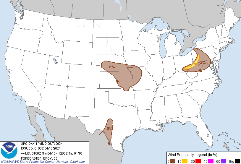
Probability of damaging thunderstorm winds or wind gusts of 50 knots or higher within 25 miles of a point. Hatched Area: 10% of greater probability of wind gusts 65 knots or greater within 25 miles of a point.
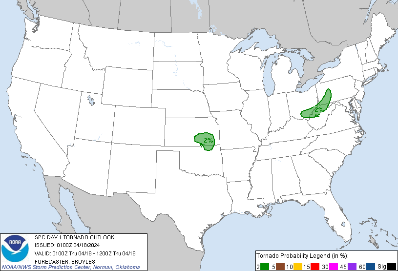
Washington, DC...Kansas City, MO...Wichita, KS...Lincoln, NE...Arlington, VA...
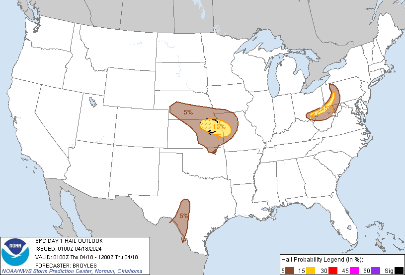
Probabilistic Large Hail Graphic
Probability of hail 1" or larger within 25 miles of a point. Hatched Area: 10% or greater probability of hail 2" or larger within 25 miles of a point.
Day 1 Hail Risk
Area (sq. mi.)
Area Pop.
Some Larger Population Centers in Risk Area
SIG SEVERE
10,230
420,470
Topeka, KS...Manhattan, KS...Junction City, KS...
15 %
29,175
3,730,368
Kansas City, MO...Overland Park, KS...Kansas City, KS...Topeka, KS...Olathe, KS...
5 %
115,601
4,131,241
Wichita, KS...Lincoln, NE...Altoona, PA...Salina, KS...Grand Island, NE...
SPC AC 180100
Day 1 Convective Outlook
NWS Storm Prediction Center Norman OK
0800 PM CDT Wed Apr 17 2024
Valid 180100Z - 181200Z
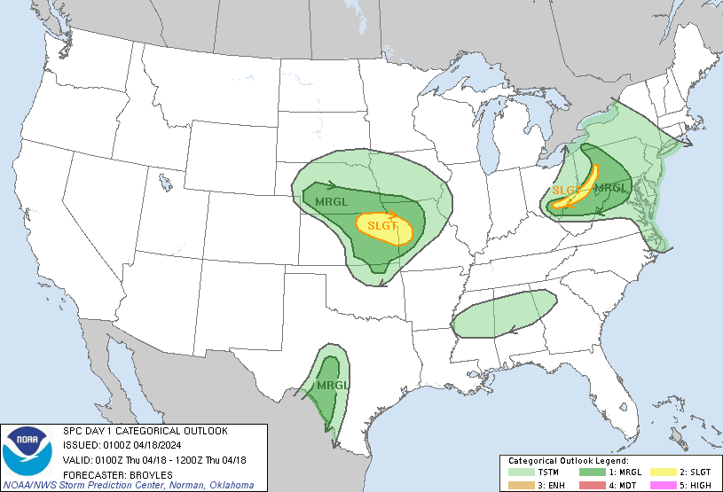
...THERE IS A SLIGHT RISK OF SEVERE THUNDERSTORMS ACROSS PARTS OF
THE UPPER OHIO VALLEY AND FROM NORTHEAST KANSAS INTO WESTERN
MISSOURI...
...SUMMARY...
Thunderstorms capable of large hail and wind damage will be possible
over the next couple of hours in the upper Ohio Valley. Marginally
severe storms will be possible this evening in parts of the central
Appalachians and Rio Grande Valley. Very large hail may occur late
this evening into the overnight period across parts of the central
Plains and Ozarks.
...Upper Ohio Valley/Central Appalachians...
A line of strong to severe storms, arching from western Pennsylvania
into southern Ohio, will continue to move eastward this evening into
the higher terrain of the central Appalachians. The storms are
located along an axis of instability, where the RAP has MLCAPE in
the 500 to 1000 J/kg range. In addition to the instability, a
vorticity max over eastern Ohio is supporting convective development
along the line. The HRRR suggests that the line will continue to
hold together for a few more hours as it moves into the central
Appalachians. RAP forecast soundings ahead of the line from
southeast of Pittsburgh, PA to Charleston, WV have 0-6 km shear near
40 knots, with 0-3 km lapse rates near 7.5 C/km. This environment
should continue to support a wind-damage threat with the stronger
cells embedded in the line. Isolated large hail could also accompany
the stronger cells that rotate. The severe threat should become
increasingly marginal as the evening progresses.
...Central Plains/Ozarks...
An upper-level trough, and an associated 60 to 80 knot mid-level
jet, will move through the central and northern Plains tonight. In
response, a 40 to 50 knot low-level jet will strengthen across
Kansas this evening. Elevated thunderstorms are expected to develop
along the northern edge of the low-level jet this evening in
southern Nebraska. Additional storms are expected to initiate in
southeast Kansas. This activity will spread northeastward into
northeast Kansas by late evening, where a warm front will be in
place from west-northwest to east-southeast. RAP forecast soundings
near and just south of the front by 06Z have MUCAPE near 2000 J/kg,
with effective shear near 40 knots. Also, 700-500 mb lapse rates are
forecast to be near 7.5 C/km. This will be favorable environment for
supercells with large hail. The strongest of storms could produce
hailstones greater than 2 inches in diameter. The storms are
expected to move into northwest Missouri and far southeast Nebraska
around or just after midnight.
...Rio Grande Valley...
At the surface, a trough is located across west-central Texas
extending southward into the Rio Grande Valley. Near the surface
trough, widely scattered thunderstorms have developed along and near
an axis of moderate instability. The RAP has MLCAPE along the
instability axis in the 1500 to 2500 J/kg range. In addition, the
RAP has 700-500 mb lapse rates near 7.5 C/km range, with 0-6 km
shear generally in the 50 to 60 knot range. This will continue to
support isolated supercell development for a few more hours this
evening. Isolated large hail and marginally severe wind gusts will
be the primary threats.
..Broyles.. 04/18/2024
CLICK TO GET WUUS01 PTSDY1 PRODUCT
NOTE: THE NEXT DAY 1 OUTLOOK IS SCHEDULED BY 0600Z