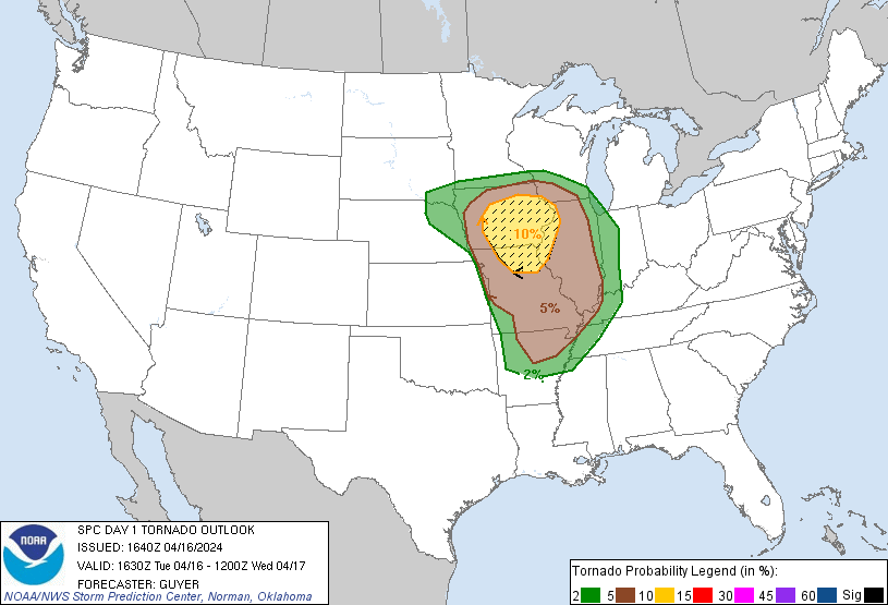
Probability of a tornado within 25 miles of a point. Hatched Area: 10% or greater probability of EF2 - EF5 tornadoes within 25 miles of a point.
Day 1 Tornado Risk
Area (sq. mi.)
Area Pop.
Some Larger Population Centers in Risk Area
SIG SEVERE
50,009
2,962,445
Des Moines, IA...Cedar Rapids, IA...Davenport, IA...Waterloo, IA...Iowa City, IA...
10 %
49,769
2,968,610
Des Moines, IA...Cedar Rapids, IA...Davenport, IA...Waterloo, IA...Iowa City, IA...
5 %
137,768
12,766,298
Kansas City, MO...St. Louis, MO...Madison, WI...Aurora, IL...Overland Park, KS...
2 %
100,785
17,438,130
Chicago, IL...Memphis, TN...Omaha, NE...Little Rock, AR...Naperville, IL...
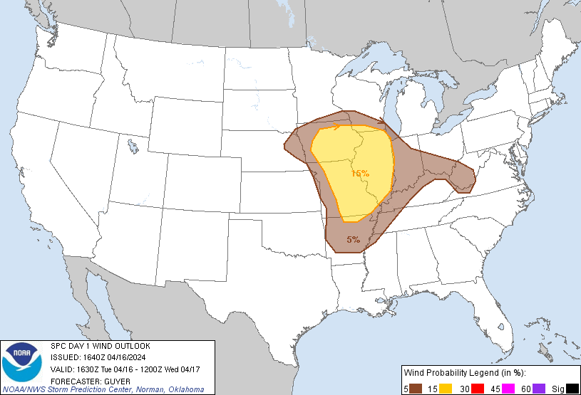
Probabilistic Damaging Wind Graphic
Probability of damaging thunderstorm winds or wind gusts of 50 knots or higher within 25 miles of a point. Hatched Area: 10% of greater probability of wind gusts 65 knots or greater within 25 miles of a point.
Indianapolis, IN...Memphis, TN...Kansas City, MO...Omaha, NE...Cincinnati, OH...
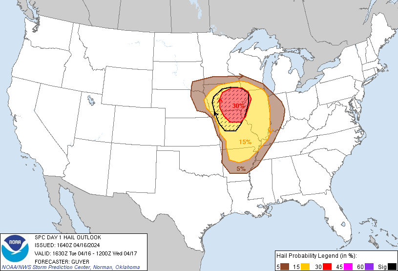
Probabilistic Large Hail Graphic
Probability of hail 1" or larger within 25 miles of a point. Hatched Area: 10% or greater probability of hail 2" or larger within 25 miles of a point.
Day 1 Hail Risk
Area (sq. mi.)
Area Pop.
Some Larger Population Centers in Risk Area
SIG SEVERE
65,216
3,813,304
Des Moines, IA...Cedar Rapids, IA...Independence, MO...Davenport, IA...Columbia, MO...
30 %
45,715
2,844,422
Des Moines, IA...Cedar Rapids, IA...Davenport, IA...Waterloo, IA...Iowa City, IA...
15 %
157,547
21,438,123
Chicago, IL...Kansas City, MO...Omaha, NE...St. Louis, MO...Madison, WI...
5 %
114,897
12,684,392
Indianapolis, IN...Memphis, TN...Lincoln, NE...Little Rock, AR...Sioux Falls, SD...
SPC AC 161640
Day 1 Convective Outlook
NWS Storm Prediction Center Norman OK
1140 AM CDT Tue Apr 16 2024
Valid 161630Z - 171200Z
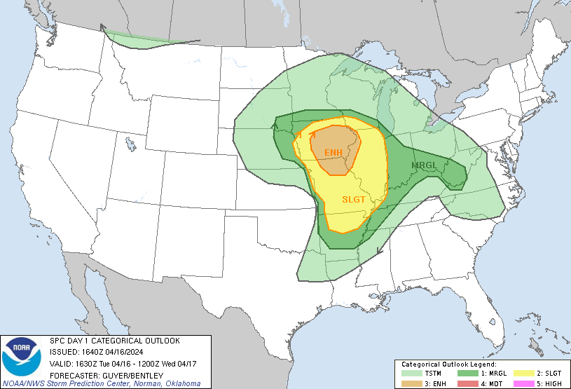
...THERE IS AN ENHANCED RISK OF SEVERE THUNDERSTORMS ACROSS THE
MIDWEST AND MIDDLE MISSISSIPPI VALLEY...
...SUMMARY...
Scattered severe thunderstorms are likely today, especially across
northern Missouri, Iowa, and northwestern Illinois. Large hail,
damaging winds, and tornadoes are expected. More isolated activity
could develop as far south as the Ozarks and Mid-South.
...Midwest/Middle Mississippi Valley...
Regenerative scattered showers and thunderstorms continue to occur
across western/northern Missouri into much of Iowa at late morning,
originating with a warm sector that narrows with north-northwestward
extent into southern Iowa and far east/northeast Nebraska in
vicinity of the surface low. Even while warm-sector cloud breaks
have been limited, steady early-spring heating and low-level
moistening is occurring with surface dewpoints rising through the
lower 60s F.
This development coincides with an intense/cyclonically curved 90+
kt polar jet and a low-level jet that will remain diurnally strong
(40+ kt). Modest cloud breaks aside, destabilization will be further
aided by a pocket of steep mid-level lapse rates and cold
temperatures aloft on the southeast side of the upper trough/low.
Scenario supports a risk for supercells especially across northern
Missouri into southern/eastern Iowa and northwest Illinois.
Steep mid-level lapse rates will aid in hail production, with a few
golf ball or 2+ inch diameter stones possible with the more robust
cores. Tornadoes will also be a concern, as the enhanced
boundary-layer flow and enlarged/curved hodographs associated with
the low-level jet will aid in updraft rotation. The main tornado
potential is still expected to be focused along/near the warm front
in southern/eastern Iowa where the stronger low-level shear is
forecast. A strong (EF2+) tornado is possible. Isolated to scattered
damaging winds are otherwise expected regionally.
Farther south toward the Ozarks and Mid-South, a potential for at
least isolated severe thunderstorms remains apparent into this
evening, with a moist/confluent regime near/ahead of the
eastward-advancing front. Mid-level lapse rates will remain limited.
However, steady low-level moistening will tend to counteract a
tendency for nocturnal boundary cooling, netting a scenario with
limited warm-sector inhibition tonight, supporting the possibility
of supercells capable of all severe hazards including a tornado
risk, even if severe storms remain relatively isolated overall.
..Guyer/Bentley.. 04/16/2024
CLICK TO GET WUUS01 PTSDY1 PRODUCT
NOTE: THE NEXT DAY 1 OUTLOOK IS SCHEDULED BY 2000Z