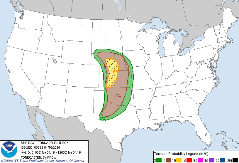
Probability of a tornado within 25 miles of a point. Hatched Area: 10% or greater probability of EF2 - EF5 tornadoes within 25 miles of a point.
Day 1 Tornado Risk
Area (sq. mi.)
Area Pop.
Some Larger Population Centers in Risk Area
SIG SEVERE
39,004
464,520
Grand Island, NE...Kearney, NE...Dodge City, KS...Hastings, NE...Hays, KS...
10 %
39,485
467,073
Grand Island, NE...Kearney, NE...Dodge City, KS...Hastings, NE...Hays, KS...
5 %
143,201
5,755,507
Oklahoma City, OK...Omaha, NE...Wichita, KS...Lincoln, NE...Topeka, KS...
2 %
96,584
9,518,680
Dallas, TX...Fort Worth, TX...Kansas City, MO...Tulsa, OK...Arlington, TX...
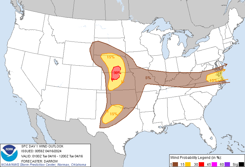
Probabilistic Damaging Wind Graphic
Probability of damaging thunderstorm winds or wind gusts of 50 knots or higher within 25 miles of a point. Hatched Area: 10% of greater probability of wind gusts 65 knots or greater within 25 miles of a point.
Day 1 Wind Risk
Area (sq. mi.)
Area Pop.
Some Larger Population Centers in Risk Area
30 %
13,299
245,723
Grand Island, NE...Kearney, NE...Hastings, NE...Hays, KS...
15 %
115,726
4,736,268
Virginia Beach, VA...Norfolk, VA...Chesapeake, VA...Richmond, VA...Newport News, VA...
5 %
416,763
34,946,551
Dallas, TX...Fort Worth, TX...Oklahoma City, OK...Kansas City, MO...Omaha, NE...
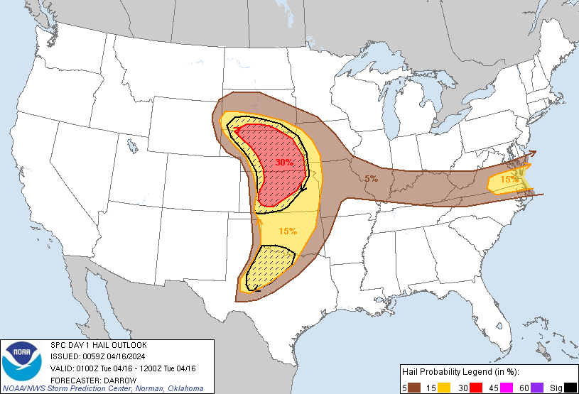
Probabilistic Large Hail Graphic
Probability of hail 1" or larger within 25 miles of a point. Hatched Area: 10% or greater probability of hail 2" or larger within 25 miles of a point.
Day 1 Hail Risk
Area (sq. mi.)
Area Pop.
Some Larger Population Centers in Risk Area
SIG SEVERE
158,239
3,822,475
Omaha, NE...Wichita, KS...Lincoln, NE...Abilene, TX...Wichita Falls, TX...
30 %
81,750
1,619,041
Lincoln, NE...Salina, KS...Manhattan, KS...Grand Island, NE...Hutchinson, KS...
15 %
203,229
12,285,521
Oklahoma City, OK...Kansas City, MO...Virginia Beach, VA...Omaha, NE...Tulsa, OK...
SPC AC 160059
Day 1 Convective Outlook
NWS Storm Prediction Center Norman OK
0759 PM CDT Mon Apr 15 2024
Valid 160100Z - 161200Z
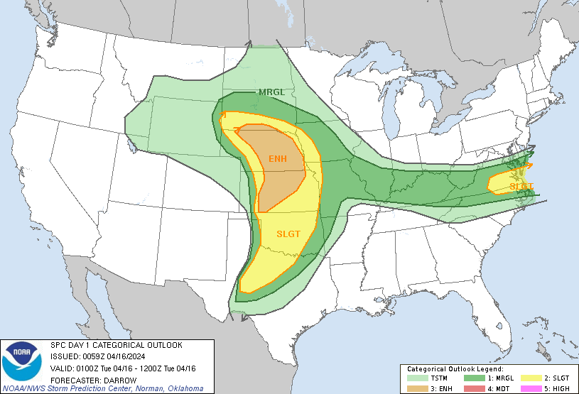
...THERE IS AN ENHANCED RISK OF SEVERE THUNDERSTORMS ACROSS PORTIONS
OF THE CENTRAL PLAINS...
...THERE IS A SLIGHT RISK OF SEVERE THUNDERSTORMS SURROUNDING THE
ENH RISK OVER THE PLAINS...AND ACROSS A SMALL PART OF THE MIDDLE
ATLANTIC THIS EVENING...
...SUMMARY...
Scattered severe thunderstorms are expected across parts of the
Great Plains tonight. Several tornadoes, perhaps strong, large to
very large hail, and damaging wind gusts all appear possible.
Scattered severe gusts will linger this evening across portions of
the middle Atlantic.
...01z Update...
Early-evening water-vapor imagery depicts moistening at midlevels
across southwestern NE/western KS into the eastern OK Panhandle.
This is likely the leading edge of large-scale ascent that is
spreading into the central Plains. Over the last hour or so,
boundary-layer cu have gradually deepened along the dryline and
lightning may soon develop with strengthening updrafts. Supercells
are expected to evolve along this corridor soon and subsequent
movement downstream into the central Plains is anticipated, in line
with 20z outlook. Environmental shear/buoyancy favor very large
hail, damaging winds, and tornadoes.
Farther south across the TX South Plains, strong surface heating has
contributed to dry adiabatic surface-3km lapse rates. 00z sounding
from MAF supports this and surface-6km bulk shear is also around
60kt. Earlier thunderstorm activity that evolved over northwest TX
has struggled to organize, but agitated boundary-layer cu might
organize along the dryline between LBB-ABI. Increasing large-scale
ascent could encourage upscale growth over the next few hours.
Across the middle Atlantic, a narrow corridor of instability has yet
to be overturned across southeastern VA, immediately ahead of
convection that is sagging into this region. 00z soundings from
GSO/MHX do not exhibit appreciable buoyancy with seasonally low PWs
farther south. Gusty winds, along with some risk for hail, continues
for the next few hours with convection has it settles south toward
the VA/NC border. Otherwise, overall severe risk appears to be
gradually lowering.
..Darrow.. 04/16/2024
CLICK TO GET WUUS01 PTSDY1 PRODUCT
NOTE: THE NEXT DAY 1 OUTLOOK IS SCHEDULED BY 0600Z