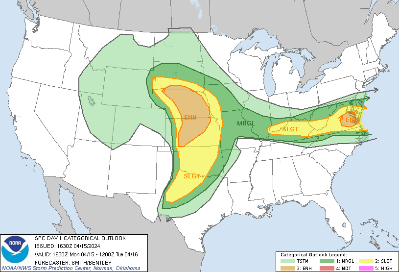
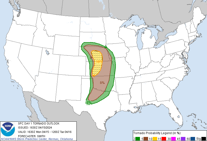
Probability of a tornado within 25 miles of a point. Hatched Area: 10% or greater probability of EF2 - EF5 tornadoes within 25 miles of a point.
Day 1 Tornado Risk
Area (sq. mi.)
Area Pop.
Some Larger Population Centers in Risk Area
SIG SEVERE
39,004
464,520
Grand Island, NE...Kearney, NE...Dodge City, KS...Hastings, NE...Hays, KS...
10 %
39,485
467,073
Grand Island, NE...Kearney, NE...Dodge City, KS...Hastings, NE...Hays, KS...
5 %
142,251
5,754,104
Oklahoma City, OK...Omaha, NE...Wichita, KS...Lincoln, NE...Topeka, KS...
2 %
97,534
9,520,082
Dallas, TX...Fort Worth, TX...Kansas City, MO...Tulsa, OK...Arlington, TX...
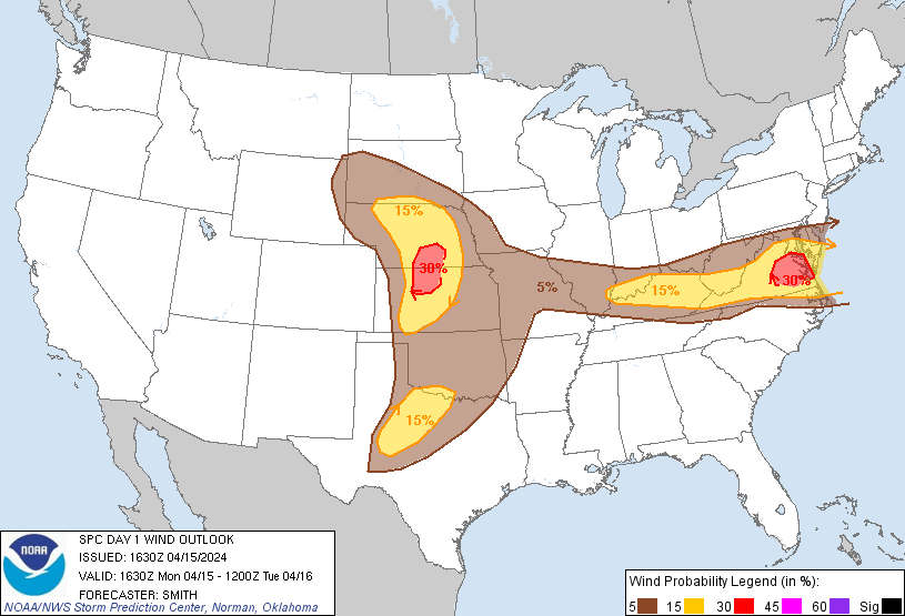
Probabilistic Damaging Wind Graphic
Probability of damaging thunderstorm winds or wind gusts of 50 knots or higher within 25 miles of a point. Hatched Area: 10% of greater probability of wind gusts 65 knots or greater within 25 miles of a point.
Day 1 Wind Risk
Area (sq. mi.)
Area Pop.
Some Larger Population Centers in Risk Area
30 %
24,381
2,344,450
Richmond, VA...Newport News, VA...Hampton, VA...Grand Island, NE...Tuckahoe, VA...
15 %
169,632
13,376,476
Washington, DC...Virginia Beach, VA...Louisville, KY...Norfolk, VA...Lexington-Fayette, KY...
5 %
377,740
32,011,657
Dallas, TX...Fort Worth, TX...Baltimore, MD...Oklahoma City, OK...Kansas City, MO...
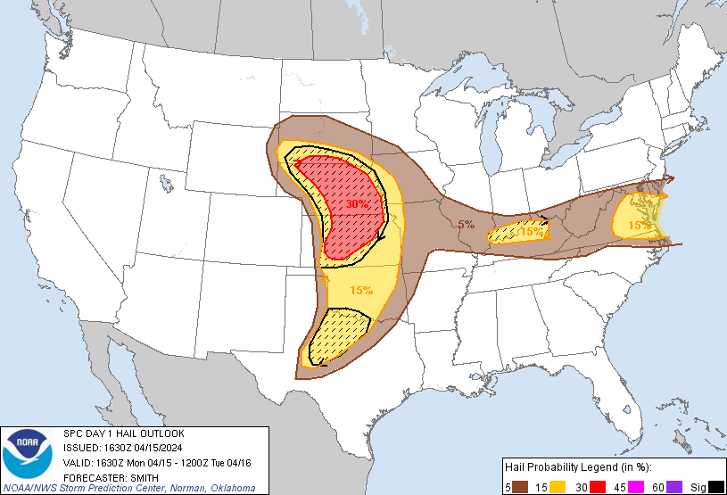
Probabilistic Large Hail Graphic
Probability of hail 1" or larger within 25 miles of a point. Hatched Area: 10% or greater probability of hail 2" or larger within 25 miles of a point.
   SPC AC 151630

   Day 1 Convective Outlook
   NWS Storm Prediction Center Norman OK
   1130 AM CDT Mon Apr 15 2024

   Valid 151630Z - 161200Z

   ...THERE IS AN ENHANCED RISK OF SEVERE THUNDERSTORMS ACROSS PARTS OF
   THE CENTRAL GREAT PLAINS AND CENTRAL AND EASTERN VIRGINIA...

   ...SUMMARY...
   Scattered severe thunderstorms are likely across parts of the Great
   Plains, beginning mainly this evening and continuing overnight.
   Several tornadoes, large to very large hail, and damaging wind gusts
   all appear possible.  Strong tornadoes may occur this evening across
   parts of Kansas and Nebraska.  Scattered severe gusts are probable
   this afternoon into the evening across portions of Virginia.

   ...Synopsis...
   Water-vapor imagery this morning shows a large, closed upper cyclone
   over UT with this feature ejecting over the southern/central Plains
   tonight.  A strong mid/upper-level jet will overspread much of the
   southern/central Plains while a cyclone deepens over the High Plains
   today.  Southerly low-level flow will facilitate moisture return
   northward concurrent with a warm front advancing northward across
   the central Great Plains.  A dryline is forecast to mix eastward
   across the southern/central High Plains through peak afternoon
   heating, before retreating westward this evening across parts of the
   TX/OK Panhandles and western KS.

   ...Northern/Central Plains (Kansas/Nebraska/South Dakota)...
   No appreciable change in thinking from the previous forecast in the
   overall severe scenario for later today/tonight.  Capping will
   likely inhibit storm initiation over the northern/central Plains
   through at least late afternoon.  However, strong southerly
   low-level flow will advect increasingly rich moisture northward with
   upper 50s to low 60s surface dewpoints by early this evening across
   the warm sector.  Prior to storm initiation, 2000-3000 J/kg MLCAPE
   is forecast concurrent with strengthening mid/upper-level flow.

   Once convective initiation occurs (early evening), rapid supercell
   development is expected as a LLJ intensifies.  Large to very large
   hail (around 2-3 inches in diameter) will be a threat with any
   supercells that can form along/near the warm front, or southward
   along the length of the dryline into western KS.  Enlarged
   hodographs during the evening will occur through midnight while some
   additional increase in low-level moisture acts to counter increasing
   CINH due to cooling surface temperatures.  If a few discrete
   supercells can maintain a feed of effective near-surface inflow
   parcels, the tornado risk will likely become focused with those
   storms.  Given the strength of shear/buoyancy combination, strong
   tornadoes appear possible this evening/tonight across portions of
   KS/NE.  As additional storms develop, an evolving cluster growing
   upscale will potentially yield severe gusts, most likely from
   north-central KS into central NE overnight.

   ...Southern Plains (Oklahoma/Texas)...
   A lower coverage of storms is expected to develop farther south
   along the dryline over parts of the southern Great Plains late this
   afternoon into tonight.  Ample mid to high-level clouds will tend to
   limit daytime heating to some extent along the length of the
   dryline.  However, model guidance shows sufficient agreement in
   depicting storm development across parts of northwest TX by late
   this afternoon.  Supercells appear likely with this activity given
   strong (50-60 kt) deep-layer shear and large buoyancy.  Isolated
   large to very large hail will probably be the main threat with this
   convection as it moves towards north-central TX. But, occasional
   severe/damaging winds and perhaps a couple of tornadoes may also
   occur through the early evening.  Most guidance indicates any
   supercells which develop will weaken with eastward extent as they
   encounter increasing MLCIN, and become increasingly displaced from
   the better large-scale ascent with the upper trough/low ejecting
   over the central Plains.  A highly conditional severe threat remains
   apparent across OK late this afternoon and evening, with a favorable
   parameter space to support supercells capable of producing all
   severe hazards.  But, much of OK may have a relative minimum in
   convective activity until late tonight as a Pacific cold front
   overtakes the dryline.

   ...Lower OH Valley into the Mid-Atlantic states...
   Morning surface mesoanalysis places a residual frontal zone draped
   over central IN/OH with a low-level moisture reservoir (low 60s deg
   F surface dewpoints) extending from the confluence of the MS/OH
   rivers northeastward into the lower Wabash Valley.  Atop this
   moisture, a plume of steep 700-500 mb lapse rates (8.0 to 8.3 deg
   C/km) sampled at the Lincoln, IL and Wilmington, OH raob sites, will
   overspread the OH Valley eastward into VA today.  The richer
   low-level moisture will likely remain west of the Appalachians
   across the lower OH Valley where 1500-2500 J/kg MLCAPE is forecast.
   Widely scattered thunderstorms are forecast to develop by mid
   afternoon within the moist axis along/south of a stalled front over
   the OH Valley.  Effective shear 25-35 kt will support a mix of
   supercells and organized line segments capable of hail and wind.

   Farther east, steep lapse rates from the surface to 500 mb are
   depicted in forecast soundings by early to mid afternoon (8 deg
   C/km).  Although PW will be lower across the Mid-Atlantic region, a
   more deeply mixed boundary layer is forecast with strong westerly
   mid-level flow (40 kt).  Initial cellular storms will likely develop
   over the higher terrain with subsequent development across northern
   VA.  A band of storms posing a risk for severe gusts (60-70 mph) and
   resultant wind damage is forecast.  Given the lapse rate profile
   coupled with ample mid- to high-level flow and a linear mode, have
   increased wind probabilities and an upgrade to level 3 categorical
   outlook this update.  The overall severe threat should gradually
   diminish through late evening with the loss of diurnal heating.

   ..Smith/Bentley.. 04/15/2024

   CLICK TO GET WUUS01 PTSDY1 PRODUCT

   NOTE: THE NEXT DAY 1 OUTLOOK IS SCHEDULED BY 2000Z