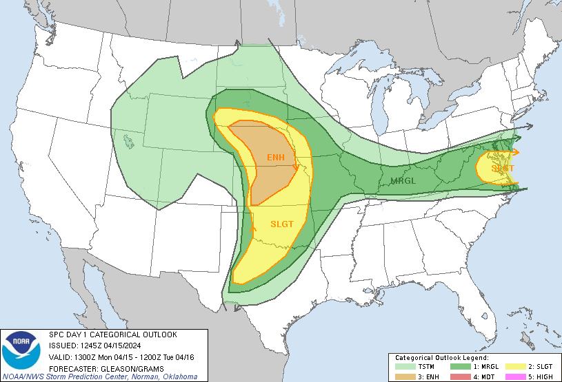
Probability of a tornado within 25 miles of a point. Hatched Area: 10% or greater probability of EF2 - EF5 tornadoes within 25 miles of a point.
Day 1 Tornado Risk
Area (sq. mi.)
Area Pop.
Some Larger Population Centers in Risk Area
SIG SEVERE
39,004
464,520
Grand Island, NE...Kearney, NE...Dodge City, KS...Hastings, NE...Hays, KS...
10 %
39,485
467,073
Grand Island, NE...Kearney, NE...Dodge City, KS...Hastings, NE...Hays, KS...
5 %
142,251
5,754,104
Oklahoma City, OK...Omaha, NE...Wichita, KS...Lincoln, NE...Topeka, KS...
2 %
101,322
9,559,135
Dallas, TX...Fort Worth, TX...Kansas City, MO...Tulsa, OK...Arlington, TX...
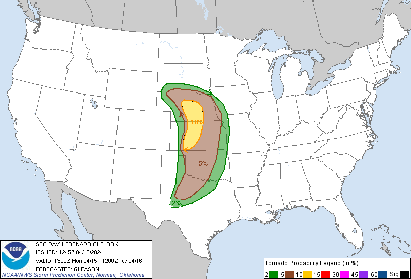
Probabilistic Damaging Wind Graphic
Probability of damaging thunderstorm winds or wind gusts of 50 knots or higher within 25 miles of a point. Hatched Area: 10% of greater probability of wind gusts 65 knots or greater within 25 miles of a point.
Day 1 Wind Risk
Area (sq. mi.)
Area Pop.
Some Larger Population Centers in Risk Area
15 %
136,722
7,280,002
Virginia Beach, VA...Norfolk, VA...Chesapeake, VA...Richmond, VA...Newport News, VA...
5 %
431,186
39,370,361
Dallas, TX...Fort Worth, TX...Baltimore, MD...Washington, DC...Oklahoma City, OK...
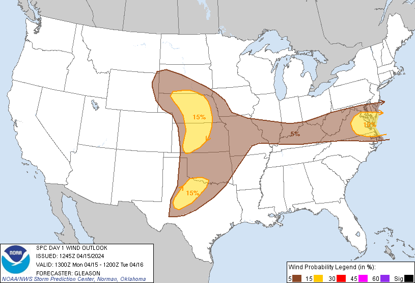
Probabilistic Large Hail Graphic
Probability of hail 1" or larger within 25 miles of a point. Hatched Area: 10% or greater probability of hail 2" or larger within 25 miles of a point.
Day 1 Hail Risk
Area (sq. mi.)
Area Pop.
Some Larger Population Centers in Risk Area
SIG SEVERE
158,154
3,822,426
Omaha, NE...Wichita, KS...Lincoln, NE...Abilene, TX...Wichita Falls, TX...
30 %
81,750
1,619,041
Lincoln, NE...Salina, KS...Manhattan, KS...Grand Island, NE...Hutchinson, KS...
15 %
210,395
14,527,849
Oklahoma City, OK...Kansas City, MO...Virginia Beach, VA...Omaha, NE...Tulsa, OK...
   SPC AC 151245

   Day 1 Convective Outlook
   NWS Storm Prediction Center Norman OK
   0745 AM CDT Mon Apr 15 2024

   Valid 151300Z - 161200Z

   ...THERE IS AN ENHANCED RISK OF SEVERE THUNDERSTORMS ACROSS PARTS OF
   THE CENTRAL PLAINS...

   ...THERE IS A SLIGHT RISK OF SEVERE THUNDERSTORMS ACROSS PARTS OF
   THE SOUTHERN MID-ATLANTIC...

   ...SUMMARY...
   Scattered severe thunderstorms are likely across parts of the Great
   Plains, beginning mainly this evening and continuing overnight.
   Several tornadoes, large to very large hail, and damaging wind gusts
   all appear possible. Strong tornadoes may occur this evening across
   parts of Kansas and Nebraska.

   ...Synopsis...
   A large, closed upper cyclone is present over the Great Basin this
   morning. This feature will track eastward across the central
   Rockies, eventually ejecting over the southern/central Plains
   tonight. A strong mid/upper-level jet attendant to this upper
   cyclone will overspread much of the southern/central Plains through
   this evening. Pronounced large-scale ascent preceding the
   upper-level trough/low will encourage additional deepening of a
   surface low over the central High Plains though the day. Moisture
   will continue streaming northward through the period in tandem with
   a warm front and persistent low-level warm/moist advection. This
   warm front should be located across NE and perhaps into far southern
   SD by late this evening, as the primary surface low consolidates
   over the NE Panhandle. A dryline is forecast to mix eastward across
   the southern/central High Plains through peak afternoon heating,
   before retreating westward this evening across parts of the TX/OK
   Panhandles and western KS.

   ...Northern/Central Plains (Kansas/Nebraska/South Dakota)...
   A cap and the late timing of large-scale ascent associated with the
   ejecting upper cyclone will likely inhibit convective development
   across the northern/central Plains through at least late afternoon.
   Still, low-level moisture will gradually increase through the day,
   with surface dewpoints of at least upper 50s to low 60s becoming
   common by early this evening across the warm sector. Steep mid-level
   lapse rates and cooling thermal profiles aloft are expected to
   contribute to substantial MLCAPE by the peak of the diurnal heating
   cycle, with values likely ranging around 2000-3000 J/kg. With
   gradually strengthening mid/upper-level flow anticipated, deep-layer
   shear should also become sufficiently strong to support a mix of
   supercells and multicells across this region.

   Convective initiation should be delayed across much of KS/NE/SD
   until around 00Z as a southerly low-level jet rapidly strengthens to
   50-60 kt. Very large hail (around 2-3 inches in diameter) will be a
   threat with any supercells that can form along/near the warm front,
   or southward along the length of the dryline into western KS.
   Low-level hodographs are forecast to become enlarged/curved in the
   00-06Z time frame tonight, and the threat for tornadoes is likewise
   expected to increase with any supercells that can persist and remain
   at least semi-discrete. Confidence has increased in a more
   concentrated corridor of tornado potential across parts of
   western/central KS into central NE, where supercells appear most
   likely in very favorable thermodynamic and kinematic parameter
   space. Given the forecast strength of the low-level shear, strong
   tornadoes appear possible this evening/tonight across this area.
   Severe/damaging winds will also be possible as convection attempts
   to grow upscale into one or more clusters overnight. Even with
   nocturnal cooling, these severe/damaging winds may persist given the
   ample reservoir of buoyancy available.

   ...Southern Plains (Oklahoma/Texas)...
   The overall coverage and severity of convection across the southern
   Plains is somewhat more uncertain compared to locations farther
   north across the central Plains. This uncertainty is largely tied to
   the influence of a sub-tropical mid/upper-level jet that will move
   over the southern Plains through the period, along with associated
   mid/upper-level cloudiness. These clouds may tend to limit daytime
   heating to some extent along the length of the dryline. Even so,
   attempts at robust convective development will probably occur across
   parts of northwest TX by late this afternoon. If this activity can
   be sustained, then supercells appear likely given ample (50-60 kt)
   deep-layer shear. Isolated large to very large hail will probably be
   the main threat with this convection as it moves towards
   north-central TX. But, occasional severe/damaging winds and perhaps
   a couple of tornadoes may also occur through the early evening. Most
   guidance indicates any supercells which develop will weaken with
   eastward extent as they encounter increasing MLCIN, and become
   increasingly displaced from the better large-scale ascent with the
   upper trough/low ejecting over the central Plains. A highly
   conditional severe threat remains apparent across OK late this
   afternoon and evening, with a favorable parameter space to support
   supercells capable of producing all severe hazards. But, much of OK
   may have a relative minimum in convective activity until late
   tonight as a Pacific cold front overtakes the dryline.

   ...Mid-Atlantic to the Mid Mississippi Valley...
   The glancing influence and modest ascent with an upper trough across
   the Northeast and eastern Canada will overspread parts of the
   Mid-Atlantic by early afternoon. Weak low-level convergence along a
   sagging cold front should be sufficient to support isolated to
   scattered thunderstorm development through the afternoon and evening
   from parts of the mid MS Valley into the OH Valley, central
   Appalachians, and southern Mid-Atlantic. Ahead of the front across
   the Mid-Atlantic, generally low 50s surface dewpoints and steepened
   mid-level lapse rates will foster around 1000-1500 J/kg of MLCAPE
   with moderately enhanced westerly mid/upper-level flow. Deep-layer
   shear across this region appears strong enough to support supercells
   with an associated threat for large hail. Damaging wind gusts may
   also occur with multicell clusters that attempt to form as they
   track generally east-southeastward through the evening hours. With
   weaker deep-layer shear across the mid MS and OH Valleys, convection
   should be somewhat less organized while still posing an isolated
   threat for hail/wind. The overall severe threat should gradually
   diminish through late evening with the loss of diurnal heating.

   ..Gleason/Grams.. 04/15/2024

   CLICK TO GET WUUS01 PTSDY1 PRODUCT

   NOTE: THE NEXT DAY 1 OUTLOOK IS SCHEDULED BY 1630Z