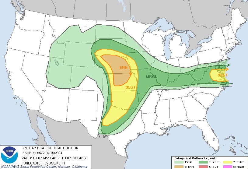
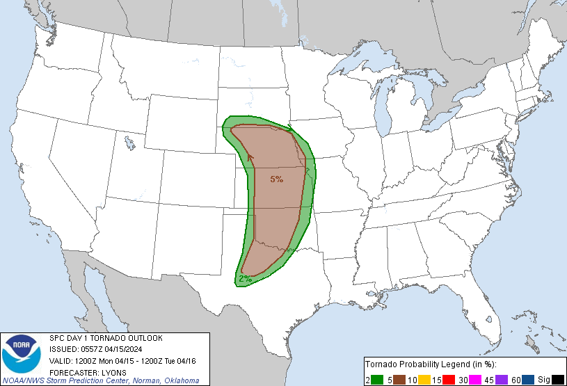
Probability of a tornado within 25 miles of a point. Hatched Area: 10% or greater probability of EF2 - EF5 tornadoes within 25 miles of a point.
Day 1 Tornado Risk
Area (sq. mi.)
Area Pop.
Some Larger Population Centers in Risk Area
5 %
178,402
6,206,097
Oklahoma City, OK...Omaha, NE...Wichita, KS...Lincoln, NE...Topeka, KS...
2 %
86,919
4,426,558
Kansas City, MO...Tulsa, OK...Overland Park, KS...Kansas City, KS...Olathe, KS...
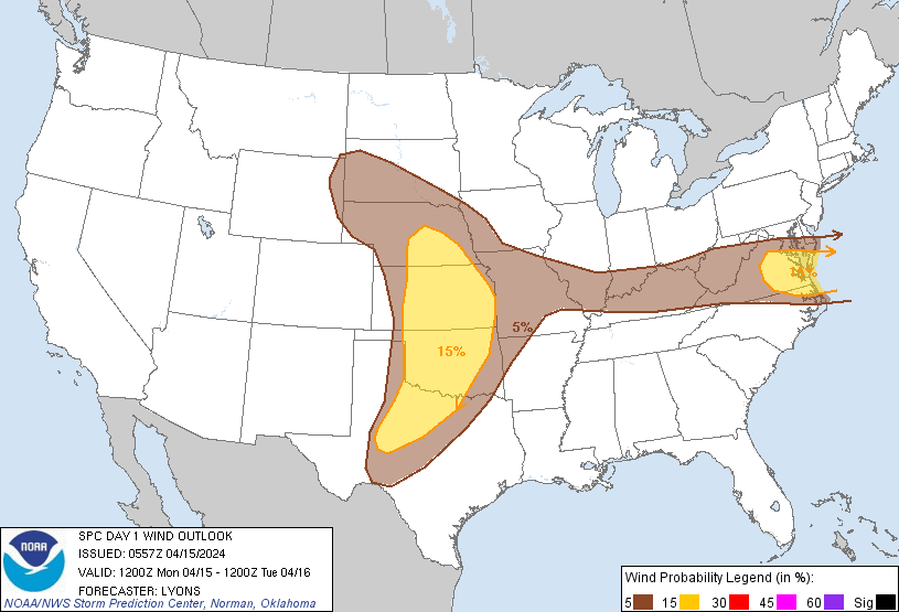
Probabilistic Damaging Wind Graphic
Probability of damaging thunderstorm winds or wind gusts of 50 knots or higher within 25 miles of a point. Hatched Area: 10% of greater probability of wind gusts 65 knots or greater within 25 miles of a point.
Day 1 Wind Risk
Area (sq. mi.)
Area Pop.
Some Larger Population Centers in Risk Area
15 %
186,794
10,674,312
Oklahoma City, OK...Virginia Beach, VA...Tulsa, OK...Wichita, KS...Norfolk, VA...
5 %
366,939
30,393,270
Dallas, TX...Fort Worth, TX...Washington, DC...Kansas City, MO...Omaha, NE...
Probabilistic Large Hail Graphic
Probability of hail 1" or larger within 25 miles of a point. Hatched Area: 10% or greater probability of hail 2" or larger within 25 miles of a point.
Day 1 Hail Risk
Area (sq. mi.)
Area Pop.
Some Larger Population Centers in Risk Area
SIG SEVERE
140,004
3,428,106
Omaha, NE...Wichita, KS...Lincoln, NE...Abilene, TX...Wichita Falls, TX...
30 %
72,807
1,541,236
Lincoln, NE...Salina, KS...Manhattan, KS...Grand Island, NE...Hutchinson, KS...
15 %
206,685
12,774,257
Oklahoma City, OK...Kansas City, MO...Virginia Beach, VA...Omaha, NE...Tulsa, OK...
   SPC AC 150557

   Day 1 Convective Outlook
   NWS Storm Prediction Center Norman OK
   1257 AM CDT Mon Apr 15 2024

   Valid 151200Z - 161200Z

   ...THERE IS AN ENHANCED RISK OF SEVERE THUNDERSTORMS ACROSS PORTIONS
   OF SOUTH DAKOTA...NEBRASKA...AND KANSAS...

   ...THERE IS A SLIGHT RISK OF SEVERE THUNDERSTORMS PORTIONS OF THE
   MID ATLANTIC...

   ...SUMMARY...
   Scattered severe thunderstorms are likely across the southern to
   central Great Plains, mainly this evening and into tonight. Large to
   very large hail, damaging wind gusts, and a few tornadoes are
   possible. More isolated severe storms are also possible over parts
   of the Ohio Valley and Mid Atlantic with a risk for mainly damaging
   winds and hail.

   ...Synopsis...
   An upper low over the western Great Basin is forecast to amplify
   considerably as it begins to phase with an increasingly strong
   mid-level subtropical jet located over the Southwestern US. Early
   morning WV imagery and RAOBS show this jet is currently moving out
   of northern MEX into southern AZ and NM. As the upper low and jet
   amplify, they will move eastward and spread broad-scale ascent over
   much of the southern and central High Plains late in the diurnal
   cycle. At the same time, a subtle mid-level perturbation east of the
   building central US ridge will move south overspreading a modestly
   warm air mass near a slowly sagging cold front in the Mid Atlantic.
   An initially diffuse lee trough/weak cyclone is forecast to quickly
   consolidate and deepen below 1000 mb over eastern CO and western NE
   by late afternoon. Large-scale mass response from the approaching
   trough and deepening low will aid in advecting a fairly broad and
   increasingly moist (mid 60s F surface dewpoints) modified Gulf air
   mass northward, east of a sharp dryline. While some uncertainty
   exists regarding convective initiation owing to the late arrival of
   large-scale ascent, mid and high-level cloud cover and capping,
   scattered severe thunderstorms capable of all hazards are possible
   over much of the Plains. Isolated storms are also possible over
   parts of the OH Valley and Mid Atlantic with a risk for damaging
   gusts.

   ...Central Plains Triple Point/Warm Front...
   A well defined warm front is expected to mark the northern edge of
   the ongoing moisture return near the KS/NE border at 12z. As the
   surface cyclone to the west begins to deepen, the warm front should
   lift northward into central NE and southern SD by mid afternoon.
   Strong low-level moisture advection and sheltering by mid and
   high-level clouds should allow for upper 50s to low 60s F dewpoints
   to pool near the front ahead of a subtle shortwave trough on the
   eastern periphery of the approaching upper low. Diurnal heating and
   forcing for ascent from the approaching shortwave should allow for
   removal of remaining inhibition by mid to late afternoon near and
   along the warm front and closer to the triple point. Mid-level lapse
   rates near 8-8.5 C/km and cool mid-level temps will support moderate
   buoyancy with large clockwise curved hodographs. Initial supercells
   are likely with the potential for large to very large hail. A few
   tornadoes are also possible given large low-level buoyancy and
   enhanced low-level SRH along the warm front.

   ...Central and southern Plains Dryline...
   Considerable uncertainty exists regarding diurnal convective
   development east of the dryline. Mid and high-level cloud cover from
   the active subtropical jet may stunt daytime heating/mixing while
   the later arrival of the main upper-low will limit large-scale
   ascent. With a stout EML in place, it is unclear if subtle ascent
   from embedded perturbations within the subtropical jet and the
   dryline circulation will support convective development from western
   KS and OK into the TX Panhandle during the day. CAM guidance
   suggests a few storms may develop farther south in west/western
   North TX within the deeply mixed air mass. With increasingly strong
   wind fields in place these storms would likely be supercellular with
   large to very large hail and the potential for a couple tornadoes.

   Additional development appears likely later in the evening and into
   the overnight hours as a Pacific front moves east and intersects
   with the retreating dryline. Uncertainty remains high with various
   model solutions, but higher probabilities of convective development
   appear likely across western and central KS with mid-level height
   falls and strong tropospheric flow fields increasing overnight.
   Large hail and damaging winds would be possible with this second
   round of storms, along with potential for a couple of tornadoes.

   ...Ohio Valley into VA and NC...
   Weak height falls from the subtle trough are expected to move over
   Mid Atlantic by early to mid afternoon timed with peak heating and
   modest boundary-layer moisture return. Weak surface convergence
   along a sagging cold front and surrounding terrain should be
   sufficient to support isolated to scattered thunderstorm development
   through the afternoon across the central OH Valley into eastern WV
   and northern VA. Ahead of the front, potentially low 50s F surface
   dewpoints and mid-level lapse rates of 7-8 C/km will support
   1000-1500 J/kg of MLCAPE with moderately strong mid and upper-level
   flow. Several bands or clusters of storms are expected to develop
   and may pose a risk for isolated severe hail and damaging wind gusts
   as they track east/southeast into the evening hours. The threat
   should gradually diminish after sunset with the loss of diurnal
   heating.

   ..Lyons/Kerr.. 04/15/2024

   CLICK TO GET WUUS01 PTSDY1 PRODUCT

   NOTE: THE NEXT DAY 1 OUTLOOK IS SCHEDULED BY 1300Z