Akron, OH...Scranton, PA...Cuyahoga Falls, OH...Mansfield, OH...Newark, OH...
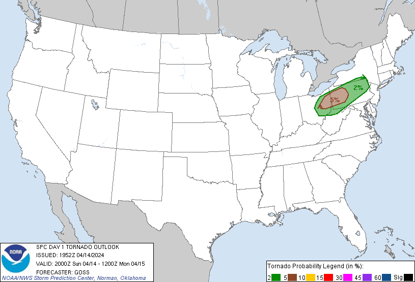
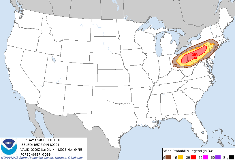
Probabilistic Damaging Wind Graphic
Probability of damaging thunderstorm winds or wind gusts of 50 knots or higher within 25 miles of a point. Hatched Area: 10% of greater probability of wind gusts 65 knots or greater within 25 miles of a point.
SPC AC 141952
Day 1 Convective Outlook
NWS Storm Prediction Center Norman OK
0252 PM CDT Sun Apr 14 2024
Valid 142000Z - 151200Z
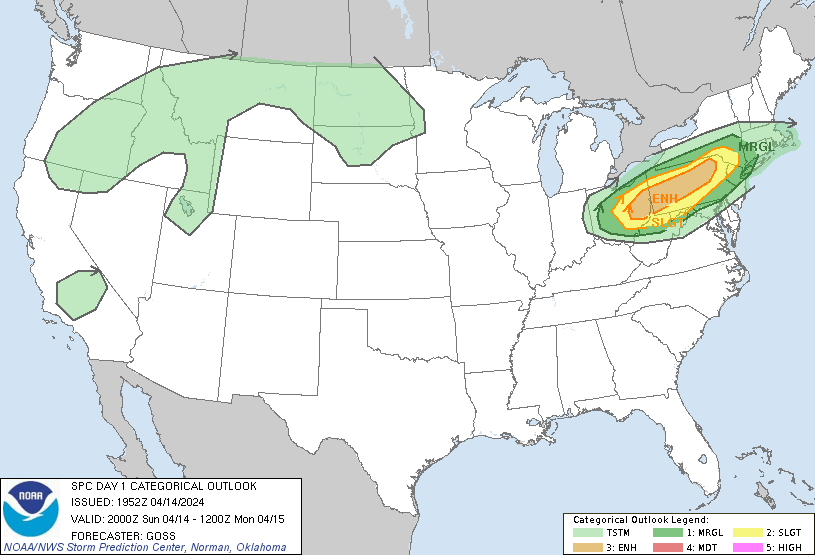
...THERE IS AN ENHANCED RISK OF SEVERE THUNDERSTORMS FROM EASTERN
OHIO EAST-NORTHEASTWARD ACROSS PENNSYLVANIA...
...SUMMARY...
Severe thunderstorms are expected to develop late this afternoon in
a narrow corridor across the upper Ohio Valley into Pennsylvania and
vicinity. Damaging winds should be the main threat. Severe hail and
perhaps a couple of tornadoes also appear possible as this activity
spreads southeastward into this evening.
...Discussion...
Aside from minor line tweaks in the northern Ohio area, the
severe-weather risk areas remain unchanged, with prior forecast
reasoning -- highlighting development of strong to severe storms
this afternoon -- still valid.
For additional short-term forecast information in this region,
please refer to SWOMCD #435.
Elsewhere, the portion of the thunder area across Nevada is being
removed in this update.
..Goss.. 04/14/2024
.PREV DISCUSSION... /ISSUED 1129 AM CDT Sun Apr 14 2024/
...Ohio Valley into the Mid-Atlantic and Northeast...
Surface analysis late this morning shows the northeastern rim of 50s
dewpoints over northern KY/southwest OH being quickly advected
east-northeastward on a 40-kt west-southwesterly LLJ. The Upper OH
Valley is located immediately downstream of a mid-level vorticity
maximum over Lake Michigan. This disturbance will continue to move
into the base of the larger-scale eastern Canada/Northeast U.S.
mid-level trough. An accompanying weak low will migrate eastward
from the Great Lakes across NY, while a weak cold front extends to
the west-southwest and is forecast to push east-southeast across the
Lower Great Lakes before weakening and becoming draped across the
Upper OH Valley late.
Continued low-level moist advection will likely result in upper 40s
to low 50s surface dewpoints within a narrow corridor along
and south of a cold front from OH into PA and southern NY. Steep
700-500 mb lapse rates due in part to cool mid levels (i.e., -18 deg
C at 500 mb) and heating will yield 500-1250 J/kg MLCAPE by mid-late
afternoon. Surface-based thunderstorm initiation across this region
will likely be delayed until 20-21Z or later, as lingering MLCIN and
a cap gradually erodes. Initial development should be focused along
the front across parts of eastern OH into western/central PA, with
additional development eventually occurring into eastern PA and
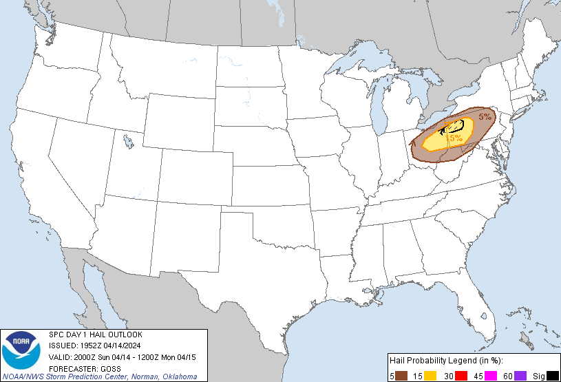
parts of southern NY. Given strong deep-layer shear and favorable
lapse rates, large hail may occur with the more robust cores
initially. Some threat for a couple of tornadoes may also exist with
quasi-discrete supercells early in the thunderstorm life cycle, as
sufficient low-level shear will be present for updraft rotation.
But, with the surface front aligned mostly parallel to the enhanced
westerly low/mid-level flow, upscale growth into small bowing
clusters will likely occur as additional storms develop and cold
pools merge as the band of storms moves southeastward. Scattered
damaging winds will then likely become the main threat with these
clusters through the early evening. As instability wanes after
sunset, the wind threat will gradually decrease with
southward/eastward extent.
CLICK TO GET WUUS01 PTSDY1 PRODUCT
NOTE: THE NEXT DAY 1 OUTLOOK IS SCHEDULED BY 0100Z