Probability of damaging thunderstorm winds or wind gusts of 50 knots or higher within 25 miles of a point. Hatched Area: 10% of greater probability of wind gusts 65 knots or greater within 25 miles of a point.
SPC AC 121943
Day 1 Convective Outlook
NWS Storm Prediction Center Norman OK
0243 PM CDT Fri Apr 12 2024
Valid 122000Z - 131200Z
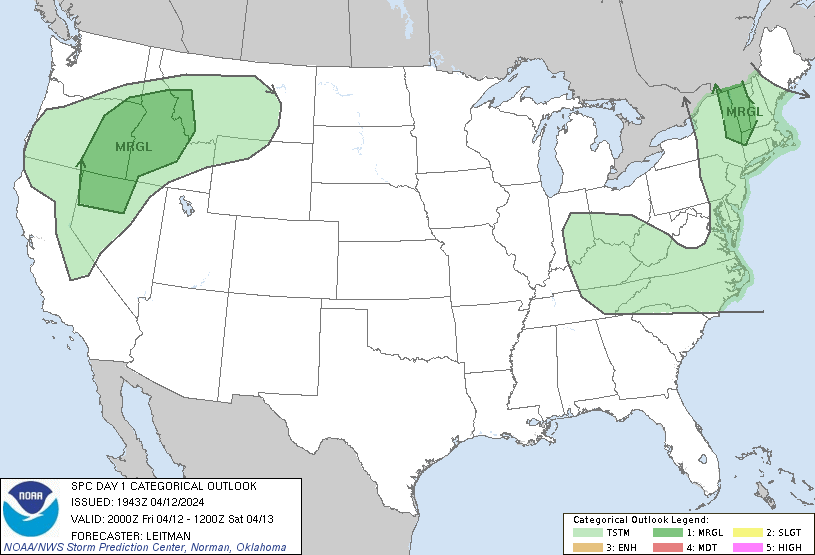
...THERE IS A MARGINAL RISK OF SEVERE THUNDERSTORMS ACROSS PARTS OF
EASTERN NEW YORK/WESTERN NEW ENGLAND AND FROM NORTHERN NEVADA TO
WESTERN MONTANA...
...SUMMARY...
Isolated severe wind gusts and hail may occur with thunderstorms
over northern Nevada, eastern Oregon, Idaho, and far western Montana
into early evening. A severe storm or two also remains possible
across portions of western New England the next few hours.
...20z Update...
The previous outlook remains on track and no changes have been made
with the 20z update. For details regarding short term severe
potential across portions of the Northwest states, refer to MCD 430.
..Leitman.. 04/12/2024
.PREV DISCUSSION... /ISSUED 1143 AM CDT Fri Apr 12 2024/
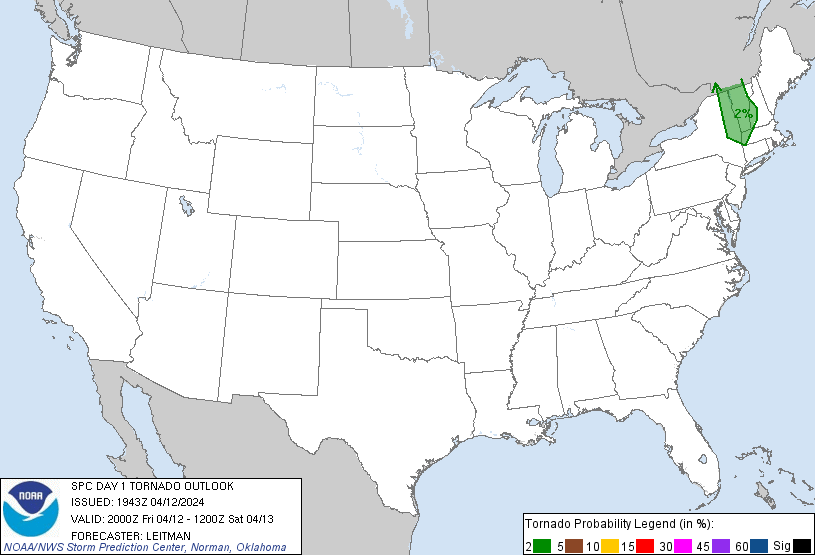
...Champlain/Hudson Valleys of New York into western New England...
Showers appear to be increasing at this time across the
Hudson/Champlain Valleys, ahead of an occluded front moving eastward
across eastern portions of Upstate New York early this afternoon. A
lobe of vorticity will continue rotating northeastward across the
region this afternoon, on the eastern fringe of the upper low
crossing the Great Lakes. Cold air aloft combined with weak
insolation through breaks in the cloud cover evident in visible
satellite imagery will permit additional/modest destabilization. As
a result, low-topped thunderstorms are expected to develop across
this area.
With deep-layer flow somewhat unidirectional/meridional, but
strengthening with height, shear will support organized storms and
potentially a few rotating updrafts. As a result, a brief/weak
tornado or two will be possible, along with gusty winds that may
approach severe levels locally, with a few stronger cells and/or
line segments. As such, a MRGL risk is being introduced across a
portion of eastern New York and into parts of western New England.
For additional short-term information, please refer to SWOMCD #429.
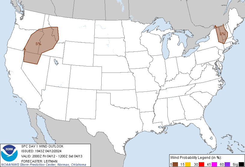
...Parts of northern Nevada to western Montana...
Ahead of the advancing upper low, daytime heating beneath steep
mid-level lapse rates will result in modest destabilization, with
degree of CAPE hindered due to scant moisture availability across
this region. Still, with a few hundred J/kg mixed-layer CAPE likely
by late afternoon, widely scattered thunderstorms are expected to
develop.
With favorably strong flow aloft across this area, a few
stronger/sustained updrafts appear likely. With a very deep
well-mixed boundary layer expected across the region, gusty
downdraft winds -- enhanced due to evaporative cooling in the
sub-cloud layer -- may reach severe levels in a few instances. This
warrants continuation of the MRGL risk across into early evening.
...Ohio Valley to the Mid-Atlantic region...
Scattered showers should diurnally increase from parts of the OH
Valley across the central Appalachians to the Virginia/North
Carolina area, with eventual/embedded low-topped thunderstorms
expected to develop within the broader area of precipitation this
afternoon.
The convection will be associated with cold mid-level temperatures
accompanying a shortwave trough, that is embedded within the broader
cyclonic circulation across the eastern CONUS. With generally
west-northwesterly flow behind the cold front, instability should
remain very weak. Still, enhanced low-level winds may reach the
surface given the anticipated well-mixed boundary layer, resulting
in occasional strong/gusty winds with a few of the stronger
convective elements.
CLICK TO GET WUUS01 PTSDY1 PRODUCT
NOTE: THE NEXT DAY 1 OUTLOOK IS SCHEDULED BY 0100Z