Pittsburgh, PA...Greensboro, NC...Durham, NC...Winston-Salem, NC...High Point, NC...
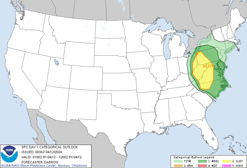
MARGINAL
105,684
23,609,352
Baltimore, MD...Washington, DC...Virginia Beach, VA...Raleigh, NC...Norfolk, VA...
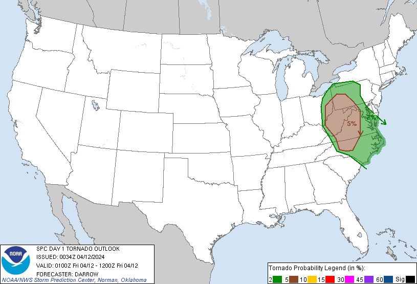
Probabilistic Tornado Graphic
Probability of a tornado within 25 miles of a point. Hatched Area: 10% or greater probability of EF2 - EF5 tornadoes within 25 miles of a point.
Day 1 Tornado Risk
Area (sq. mi.)
Area Pop.
Some Larger Population Centers in Risk Area
5 %
74,565
10,879,890
Pittsburgh, PA...Greensboro, NC...Durham, NC...Winston-Salem, NC...High Point, NC...
2 %
91,704
20,451,632
Baltimore, MD...Washington, DC...Virginia Beach, VA...Raleigh, NC...Norfolk, VA...
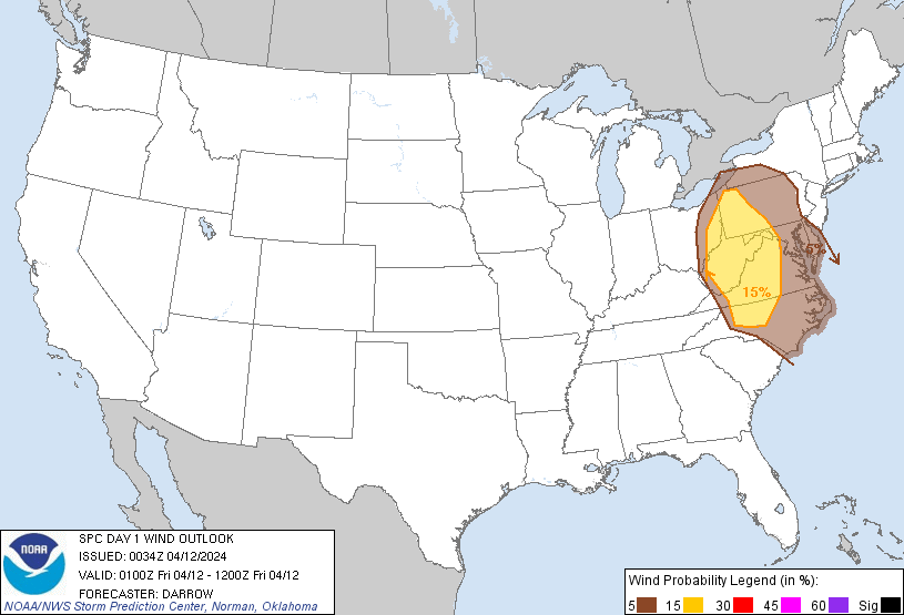
Probabilistic Damaging Wind Graphic
Probability of damaging thunderstorm winds or wind gusts of 50 knots or higher within 25 miles of a point. Hatched Area: 10% of greater probability of wind gusts 65 knots or greater within 25 miles of a point.
Day 1 Wind Risk
Area (sq. mi.)
Area Pop.
Some Larger Population Centers in Risk Area
15 %
79,093
11,305,430
Pittsburgh, PA...Greensboro, NC...Durham, NC...Winston-Salem, NC...High Point, NC...
5 %
105,818
23,990,498
Baltimore, MD...Washington, DC...Virginia Beach, VA...Raleigh, NC...Norfolk, VA...
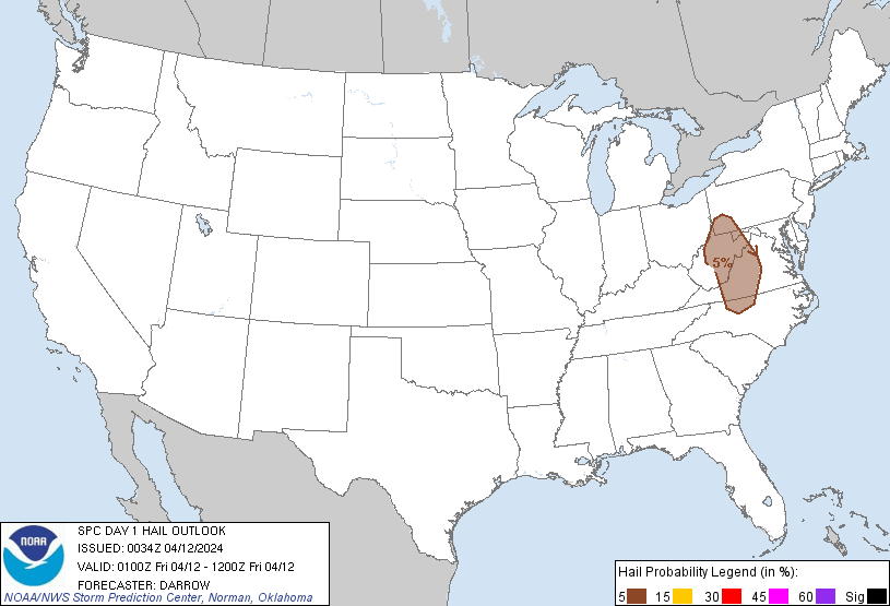
Probabilistic Large Hail Graphic
Probability of hail 1" or larger within 25 miles of a point. Hatched Area: 10% or greater probability of hail 2" or larger within 25 miles of a point.
Day 1 Hail Risk
Area (sq. mi.)
Area Pop.
Some Larger Population Centers in Risk Area
5 %
38,039
5,309,192
Pittsburgh, PA...Greensboro, NC...Winston-Salem, NC...High Point, NC...Roanoke, VA...
   SPC AC 120034

   Day 1 Convective Outlook
   NWS Storm Prediction Center Norman OK
   0734 PM CDT Thu Apr 11 2024

   Valid 120100Z - 121200Z

   ...THERE IS A SLIGHT RISK OF SEVERE THUNDERSTORMS ACROSS THE UPPER
   OHIO VALLEY AND CENTRAL APPALACHIANS...

   ...SUMMARY...
   Severe thunderstorms with a few tornadoes, scattered damaging winds,
   and isolated severe hail are possible across the upper Ohio River
   Valley and parts of the Appalachians tonight.

   ...01z Update...

   Low-amplitude southern-stream short-wave trough is advancing across
   the southern Appalachians this evening. This feature is ejecting
   northeast in response to upstream height falls ahead of digging
   Midwest trough. Leading edge of large-scale ascent appears to be
   aiding an arcing band of convection across NC into western VA.
   Additionally, a well-defined MCV is evident over central WV, and the
   southern influence of this feature may be contributing to upscale
   growth along the northern fringe of the aforementioned arcing band.
   LLJ is expected to intensify across the middle Atlantic this
   evening/overnight ahead of the approaching short wave, which will
   encourage convection to spread/develop downstream across western
   VA/MD into western PA. Strong deep-layer shear favors organized
   updrafts along with rotation. However, convective mode is complex
   and larger clusters/MCSs may be the dominant storm mode much of the
   night. Even so, some risk for tornadoes continues, along with the
   potential for damaging winds.

   ..Darrow.. 04/12/2024

   CLICK TO GET WUUS01 PTSDY1 PRODUCT

   NOTE: THE NEXT DAY 1 OUTLOOK IS SCHEDULED BY 0600Z