Probability of damaging thunderstorm winds or wind gusts of 50 knots or higher within 25 miles of a point. Hatched Area: 10% of greater probability of wind gusts 65 knots or greater within 25 miles of a point.
SPC AC 181730
Day 2 Convective Outlook
NWS Storm Prediction Center Norman OK
1230 PM CDT Wed May 18 2022
Valid 191200Z - 201200Z
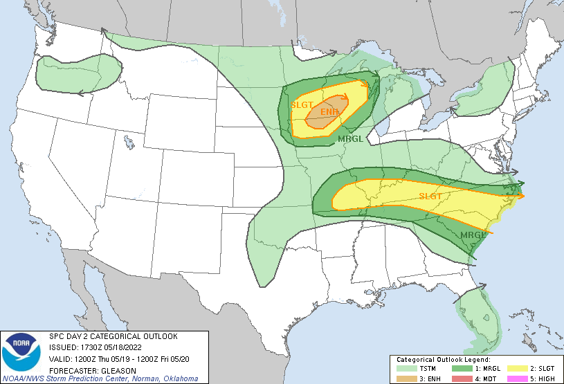
...THERE IS AN ENHANCED RISK OF SEVERE THUNDERSTORMS ACROSS PARTS OF
THE UPPER MIDWEST...
...THERE IS A SLIGHT RISK OF SEVERE THUNDERSTORMS FROM PARTS OF THE
MID MISSISSIPPI VALLEY INTO THE LOWER OHIO VALLEY AND CAROLINAS...
...SUMMARY...
Scattered severe thunderstorms appear likely late Thursday afternoon
into Thursday night over portions of the Upper Midwest. Very large
hail, damaging wind gusts, and few tornadoes all appear possible.
Additional strong to severe thunderstorms should occur from southern
Missouri eastward through the lower Ohio Valley and into the
Carolinas.
...Synopsis...
A positively tilted upper trough will move eastward across the
north-central states and eventually the Upper Midwest on Thursday.
An enhanced west-southwesterly mid/upper-level jet will accompany
this upper trough. A surface low is forecast to deepen as it
develops eastward from the northern Plains to the Upper Midwest by
Thursday evening. Rich low-level moisture should return northward as
a warm front lifts across the Midwest, mid MS Valley, and OH Valley.
A dryline should extend southward from the surface low over much of
the central/southern Plains.
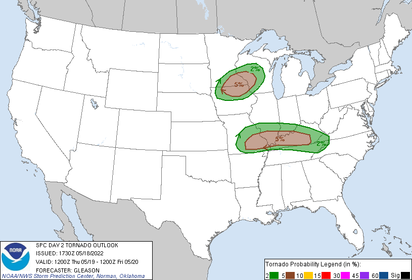
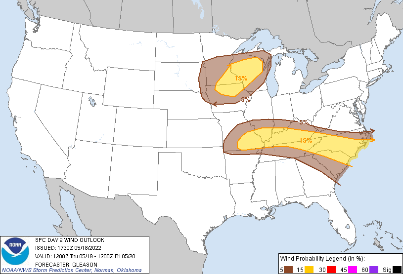
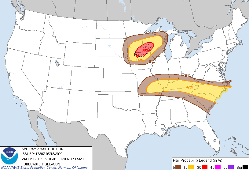
...Upper Midwest...
A cap should inhibit thunderstorm initiation through much of the day
across the Upper Midwest. Still, latest guidance suggests that the
airmass along/south of the warm front will become at least
moderately unstable by late Thursday afternoon, as ample diurnal
heating of a moistening low-level airmass occurs and steep mid-level
lapse rates overspread the warm sector. Strong deep-layer shear (50+
kt) will likely be present as well as the mid/upper-level jet
approaches from the west. Initially discrete supercells are forecast
to develop over parts of MN and perhaps northern IA by late Thursday
afternoon. These supercells should pose a threat for very large hail
given the favorable thermodynamic and kinematic environment. Any
convection that can remain at least semi-discrete may also pose a
threat for a few tornadoes early Thursday evening as low-level shear
increases in tandem with a strengthening southerly low-level jet.
Eventually, one or more small clusters may develop and pose more of
a damaging wind threat with eastward extent into Wisconsin Thursday
evening/night. Given increased confidence in supercell development
late Thursday afternoon, have increased severe hail probabilities
and included a corresponding Enhanced Risk across parts of
southeastern MN, northern IA, and western WI. The southern extent of
any appreciable severe risk will probably be limited by the strength
of the cap and warm low/mid-level temperatures with southward extent
in IA and eastern NE.
...Mid Mississippi Valley into the Lower Ohio Valley and
Carolinas...
A convectively augmented MCV is forecast to be in place somewhere in
the vicinity of northern OK and southern KS at the start of the
period Thursday morning. Most guidance suggests that thunderstorms
will redevelop and strengthen by late Thursday morning or early
afternoon across southern MO and vicinity as the MCV progresses
eastward. A narrow corridor of moderate to strong instability should
be in place along/south of a front by Thursday afternoon. A favored
corridor for severe hail and damaging winds will probably exist
along/south of this front as thunderstorms develop along the length
of the boundary through Thursday evening, with adequate shear for
both multicell clusters and perhaps a couple of supercells. Enhanced
low-level and deep-layer shear should also be present with the MCV
circulation, which may locally enhance the threat for a few
tornadoes from parts of southern MO into KY. Farther east into the
Carolinas, additional clusters of thunderstorms should also develop
through the afternoon and pose a threat for both severe hail and
damaging winds as they spread eastward to the coast through Thursday
evening.
..Gleason.. 05/18/2022
CLICK TO GET WUUS02 PTSDY2 PRODUCT
NOTE: THE NEXT DAY 2 OUTLOOK IS SCHEDULED BY 0600Z