San Antonio, TX...Dallas, TX...Fort Worth, TX...Oklahoma City, OK...New Orleans, LA...
Probabilistic Damaging Wind Graphic
Probability of damaging thunderstorm winds or wind gusts of 50 knots or higher within 25 miles of a point. Hatched Area: 10% of greater probability of wind gusts 65 knots or greater within 25 miles of a point.
Fort Worth, TX...Amarillo, TX...Wichita Falls, TX...Denton, TX...Midland, TX...
15 %
145,935
13,041,612
San Antonio, TX...Dallas, TX...Austin, TX...Oklahoma City, OK...Arlington, TX...
5 %
120,430
6,798,373
Denver, CO...Tulsa, OK...Colorado Springs, CO...Wichita, KS...Aurora, CO...
SPC AC 180049
Day 1 Convective Outlook
NWS Storm Prediction Center Norman OK
0749 PM CDT Mon May 17 2021
Valid 180100Z - 181200Z
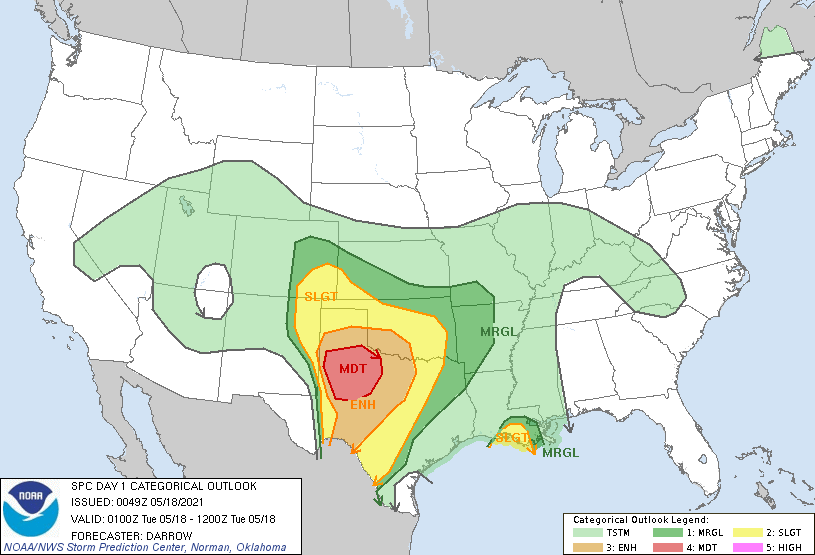
...THERE IS A MODERATE RISK OF SEVERE THUNDERSTORMS ACROSS PORTIONS
OF NORTHWESTERN TEXAS...
...THERE IS A SLIGHT RISK OF SEVERE THUNDERSTORMS SURROUNDING THE
MODERATE RISK ACROSS THE SOUTHERN PLAINS...
...SUMMARY...
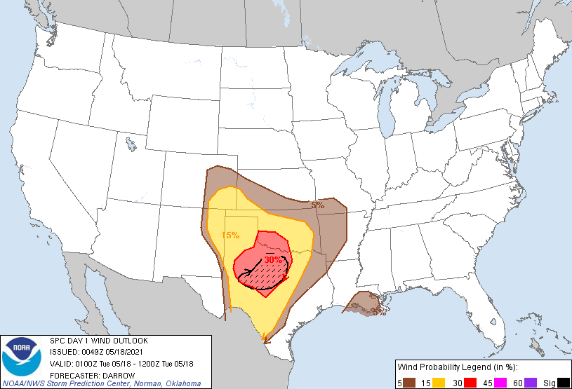
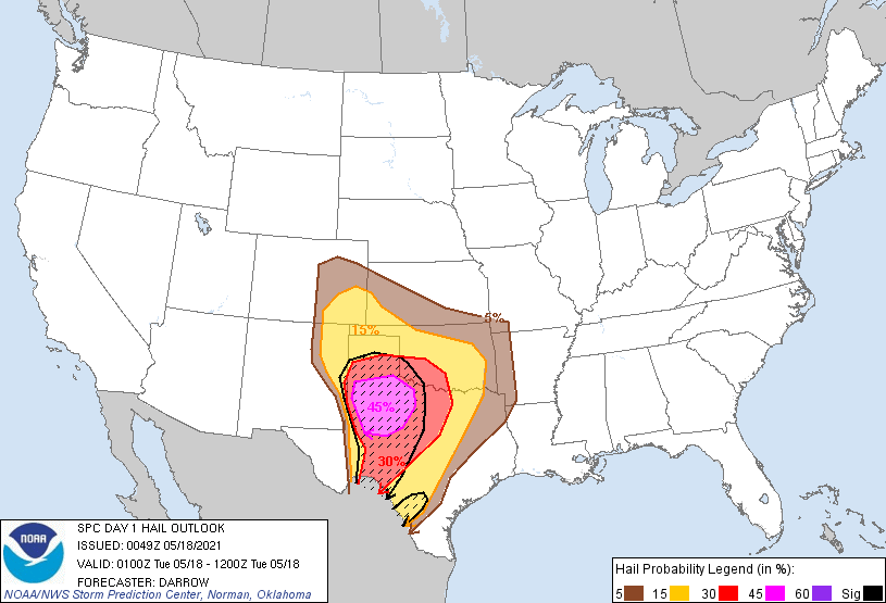
Severe thunderstorms will continue tonight across portions of the
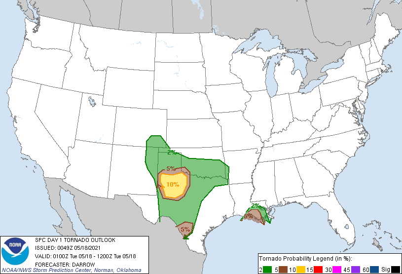
southern Plains. The potential for very large hail, a few tornadoes,
and damaging winds will be focused across a broad part of
west/northwest Texas.
...Southern Plains...
Numerous severe thunderstorms have developed across the southern
Plains from northeast NM-TX Panhandle-TX South Plains-middle Rio
Grande Valley. 00z sounding from EPZ sampled a portion of the
mid-level speed max that is translating across northern Mexico into
west TX with 50kt observed near 6km. This stronger flow aloft will
overspread the expanding complex of storms over northwest TX over
the next few hours and continued upscale growth is anticipated
through storm mergers. Latest radar data suggests an evolving MCS is
beginning to take shape along a corridor from Big
Spring-Sweetwater-Monday. This activity should mature over the next
several hours then surge east along the I-20 corridor, possibly
spreading into the western portions of the Metroplex late this
evening. Damaging wind threat may increase along the leading edge of
this complex, especially if it matures into a bow-type structure.
Another possible MCS may emerge over the TX Panhandle as numerous
thunderstorms begin to conglomerate. This activity will begin to
propagate toward western OK if a sufficient cold pool materializes
as expected.
...Southeast LA...
Slow-moving MCS has progressed across much of southwestern LA. 00z
sounding from LIX exhibits modest shear through 6km along with high
PW-air mass. This activity should propagate across southeastern LA
over the next several hours and a tornado or two can not be ruled
out with embedded weak circulations. For these reasons will maintain
some tornado threat with this MCS.
..Darrow.. 05/18/2021
CLICK TO GET WUUS01 PTSDY1 PRODUCT
NOTE: THE NEXT DAY 1 OUTLOOK IS SCHEDULED BY 0600Z