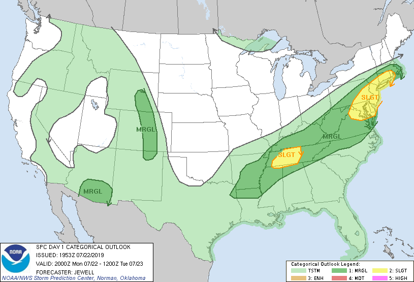
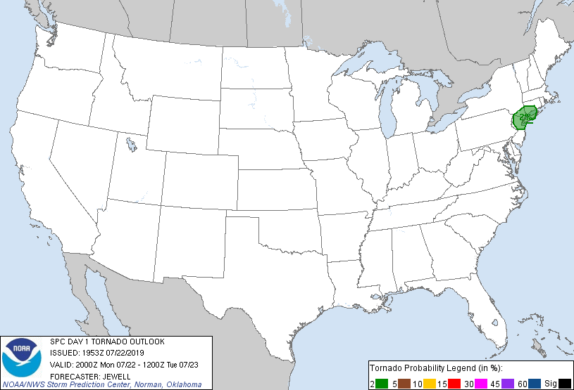
Probability of a tornado within 25 miles of a point. Hatched Area: 10% or greater probability of EF2 - EF5 tornadoes within 25 miles of a point.
Day 1 Tornado Risk
Area (sq. mi.)
Area Pop.
Some Larger Population Centers in Risk Area
2 %
9,532
20,646,716
New York, NY...Newark, NJ...Jersey City, NJ...Yonkers, NY...Paterson, NJ...
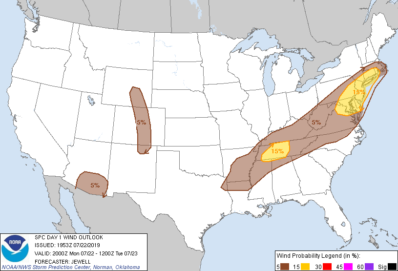
Probabilistic Damaging Wind Graphic
Probability of damaging thunderstorm winds or wind gusts of 50 knots or higher within 25 miles of a point. Hatched Area: 10% of greater probability of wind gusts 65 knots or greater within 25 miles of a point.
Day 1 Wind Risk
Area (sq. mi.)
Area Pop.
Some Larger Population Centers in Risk Area
15 %
71,215
46,317,578
New York, NY...Philadelphia, PA...Baltimore, MD...Washington, DC...Nashville, TN...
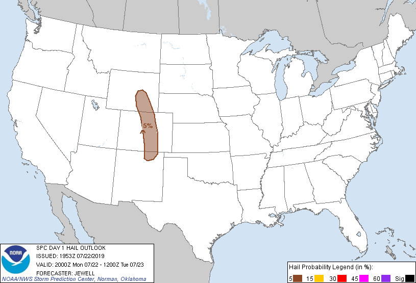
Probability of hail 1" or larger within 25 miles of a point. Hatched Area: 10% or greater probability of hail 2" or larger within 25 miles of a point.
Day 1 Hail Risk
Area (sq. mi.)
Area Pop.
Some Larger Population Centers in Risk Area
5 %
46,143
4,504,914
Denver, CO...Colorado Springs, CO...Aurora, CO...Lakewood, CO...Fort Collins, CO...
   SPC AC 221953

   Day 1 Convective Outlook
   NWS Storm Prediction Center Norman OK
   0253 PM CDT Mon Jul 22 2019

   Valid 222000Z - 231200Z

   ...THERE IS A SLIGHT RISK OF SEVERE THUNDERSTORMS ACROSS THE
   NORTHEAST/MID-ATLANTIC STATES AND TENNESSEE VALLEY...

   ...SUMMARY...
   Scattered damaging winds are possible across portions of the
   Mid-Atlantic States into southern New England, as well as the
   Tennessee Valley, this afternoon to early evening.

   No changes were made to the previous outlook.

   ..Jewell.. 07/22/2019

   .PREV DISCUSSION... /ISSUED 1135 AM CDT Mon Jul 22 2019/

   ...Mid-Atlantic States to southern New England...
   Additional amplification of the large-scale trough over the eastern
   CONUS will contribute to a slight cooling of mid-level temperatures
   and strengthening southwesterly winds aloft coincident with a
   slow-southeastward-moving front across the central Appalachians
   toward parts of the Mid-Atlantic region.

   The coverage of yesterday's storms across most of this region has
   impacted thermodynamic profiles, with surface temperatures/dewpoints
   running at least several degrees lower than this time (late
   morning/midday) yesterday. As noted in the prior Outlook discussion,
   12Z soundings from Sterling, Wallops, Upton, Pittsburgh, and
   Wilmington OH all sampled mean mixing ratios about 2-3 g/kg lower
   compared to 12Z yesterday and have weaker mid-level lapse rates.

   That said, moisture will steadily recover and ample insolation is
   noted at midday across the Mid-Atlantic in the lee of the
   Appalachians, with MLCAPE to 1500-2000 J/kg possible (highest near
   the coast). As compared to yesterday, somewhat stronger wind
   profiles between 2-6km AGL will also be a factor for individual
   storm longevity/organized storms. Multicells will be common and the
   possibility exists for a few transient supercells from far southern
   New York/northern New Jersey into southern New England. Damaging
   winds will be the most common risk through the afternoon into early
   evening.

   ...Mid-South and Tennessee Valley...
   A moist air mass (70-75F surface dewpoints) remains ahead of a
   southeastward-moving cold front. As morning cloud cover thins,
   increasing cumuliform/thunderstorm development are expected this
   afternoon, particularly downstream of a pair of residual MCVs. Wet
   microbursts yielding localized wind damage will be the main risk.

   While weak vertical shear will tend to limit overall organization
   and risk magnitude, a somewhat more focused/organized severe risk
   may exist this afternoon into early evening across western/middle
   Tennessee and nearby southern Kentucky and perhaps northern portions
   of Mississippi/Alabama. Enhanced winds are noted with the MCV near
   the Mississippi River, with 30-40 kt west-southwesterly winds
   between 4-6 km in recent (16Z) Paducah, KY WFO-88D VWP data.

   ...Central/southern Rockies and adjacent High Plains...
   Isolated thunderstorms will develop this afternoon and remain
   largely confined to the higher terrain of Wyoming/Colorado/New
   Mexico, although a few storms could drift into the immediately
   adjacent High Plains. A belt of modest mid-level north/northwesterly
   flow aloft will persist around the Four Corners/southern Rockies
   upper ridge, yielding some threat for marginally severe hail/wind.

   ...Southeast/south-central Arizona...
   On the southern periphery of the south-central Rockies-centered
   upper ridge, 15-20 kt mid-level easterlies may help loosely organize
   scattered thunderstorms that develop over the higher terrain during
   the late afternoon and move toward the desert floor. Hot/deeply
   mixed boundary layer will support vigorous downdrafts and the
   possibility of severe-caliber winds and blowing dust late this
   afternoon/early evening.

   CLICK TO GET WUUS01 PTSDY1 PRODUCT

   NOTE: THE NEXT DAY 1 OUTLOOK IS SCHEDULED BY 0100Z