|
| Mesoscale Discussion 427 |
|
< Previous MD Next MD >
|
|
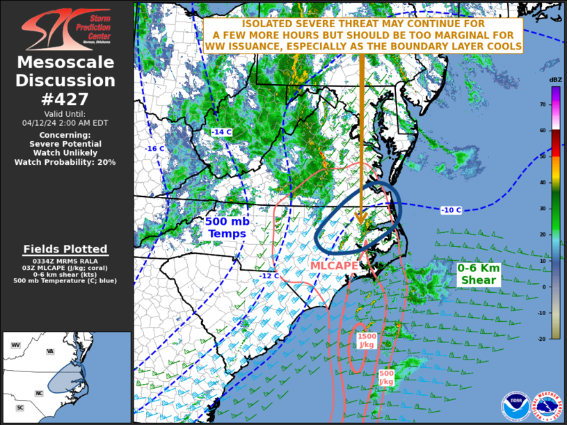
   Mesoscale Discussion 0427
   NWS Storm Prediction Center Norman OK
   1036 PM CDT Thu Apr 11 2024

   Areas affected...Northeast North Carolina...Southeast Virginia

   Concerning...Severe potential...Watch unlikely

   Valid 120336Z - 120600Z

   Probability of Watch Issuance...20 percent

   SUMMARY...An isolated severe threat may continue for a few more
   hours across parts of northeastern North Carolina and southeast
   Virginia. The threat should be too marginal for weather watch
   issuance.

   DISCUSSION...An upper-level trough is currently moving through the
   southern Appalachians according to water vapor imagery. Ahead of the
   trough, the RAP is analyzing a 60 to 70 knot low-level jet from
   eastern North Carolina into southeastern Virginia. Thunderstorms are
   developing to the west of the low-level jet in a strongly sheared
   environment, where 0-6 km shear is 50 to 60 knots and 0-3 km
   storm-relative helicity is around 350 m2/s2, according to the
   Raleigh WSR-88D VWP. This should support an isolated tornado threat
   with low-topped supercells. An isolated wind-damage threat will also
   be possible. However, the storms will continue to move northeastward
   toward the coast where instability is considerably weaker. The
   boundary layer will also continue to cool contributing to a more
   stable airmass. This should result in a severe threat becoming more
   marginal with time.

   ..Broyles/Thompson.. 04/12/2024

   ...Please see www.spc.noaa.gov for graphic product...

   ATTN...WFO...AKQ...MHX...RAH...

   LAT...LON   36957584 37187643 36857723 36257799 35827838 35587837
               35397817 35307780 35397698 35757626 36067583 36437566
               36957584
|
|
Top/All Mesoscale Discussions/Forecast Products/Home
|
|


 @NWSSPC