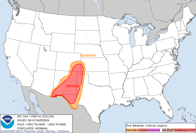
Storm Prediction Center Day 1 Fire Weather Outlook
Created: Thu Apr 25 06:16:03 UTC 2024 (
![]() |
| ![]() )
)
|
Click for Day 1 FireWX Areal Outline Product
   ZCZC SPCFWDDY1 ALL
   FNUS21 KWNS 250614

   Day 1 Fire Weather Outlook
   NWS Storm Prediction Center Norman OK
   0114 AM CDT Thu Apr 25 2024

   Valid 251200Z - 261200Z

   ...CRITICAL FIRE WEATHER AREA FOR THE SOUTHERN HIGH PLAINS AND
   SOUTHERN NEW MEXICO...

   ...Synopsis...
   A midlevel trough will track eastward across the Southwest, while an
   accompanying 60-70-kt midlevel southwesterly jet overspreads
   southern NM and the southern High Plains. This will promote rapid
   deepening of a lee cyclone over eastern CO, while a
   southward-extending dryline sharpens over west TX. This large-scale
   pattern evolution will yield an expansive area of critical
   fire-weather conditions across the aforementioned areas, with
   high-end critical conditions expected over eastern NM.

   ...Southern New Mexico and the Southern High Plains...
   Behind the sharpening dryline, strong downslope warming/drying and
   diurnal heating will contribute to a deep/dry boundary layer,
   characterized by surface temperatures in the mid/upper 80s and
   single-digit to lower-teens RH. Here, a tightening surface pressure
   gradient peripheral to the deepening lee cyclone, and mixing into
   the strong flow aloft, will support 25-35 mph sustained
   southwesterly surface winds (with gusts upwards of 45 mph). These
   conditions will yield an expansive area of high-end critical
   fire-weather conditions, given modestly receptive fuels.

   The overlap of strongest winds and lowest relative humidity is
   expected over eastern NM, where extremely critical meteorological
   conditions are likely. However, a lack of abundant and very dry
   fuels over the area precludes such highlights at this time.

   ..Weinman.. 04/25/2024

   ...Please see www.spc.noaa.gov/fire for graphic product...