Storm Prediction Center Day 1 Fire Weather Outlook
Created: Mon Apr 22 16:25:03 UTC 2024 (
![]() |
| ![]() )
)
| |||||||||
Click for Day 1 FireWX Areal Outline Product
ZCZC SPCFWDDY1 ALL
FNUS21 KWNS 221624
Day 1 Fire Weather Outlook
NWS Storm Prediction Center Norman OK
1124 AM CDT Mon Apr 22 2024
Valid 221700Z - 231200Z
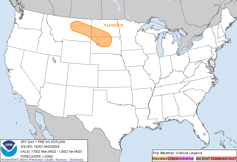
Minimal changes were made to the ongoing forecast. Several hours of
elevated to locally critical conditions are possible over parts of
the northern High Plains. Locally elevated conditions are also
possible over parts of the central Plains and upper Midwest. See the
prior discussion.
..Lyons.. 04/22/2024
.PREV DISCUSSION... /ISSUED 0155 AM CDT Mon Apr 22 2024/
...Synopsis...
A midlevel low will track east-southeastward from SK toward the
Upper Great Lakes through the period, while a related belt of strong
deep-layer west-northwesterly flow overspreads a post-frontal air
mass over the northern Plains. Here, a tight pressure gradient,
coupled with boundary-layer mixing into the enhanced flow aloft,
will favor a WNW/ESE-oriented corridor of 25-35 mph sustained
west-northwesterly surface winds (with higher gusts) amid 20-30
percent RH (locally lower). Elevated highlights have been added for
this corridor, with the southern edge bounded by
overnight/early-morning precipitation, and northern edge where
higher RH is expected. While fuels are somewhat marginal across the
region (ERCs generally in the 60th-80th percentile), the
strong/gusty winds and modest RH reductions warrant these
highlights.
Ahead of the primary cold front, a swath of strong
south-southwesterly surface winds will extend from the southern
Plains into the Midwest. While higher boundary-layer moisture (and
related RH) is expected across this corridor, locally elevated
conditions are still possible where fine fuels are receptive to
fire-spread (e.g., parts of western KS).
...Please see www.spc.noaa.gov/fire for graphic product...