Storm Prediction Center Day 1 Fire Weather Outlook
Created: Mon Apr 22 06:56:03 UTC 2024 (
![]() |
| ![]() )
)
| |||||||||
Click for Day 1 FireWX Areal Outline Product
ZCZC SPCFWDDY1 ALL
FNUS21 KWNS 220655
Day 1 Fire Weather Outlook
NWS Storm Prediction Center Norman OK
0155 AM CDT Mon Apr 22 2024
Valid 221200Z - 231200Z
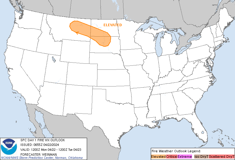
...Synopsis...
A midlevel low will track east-southeastward from SK toward the
Upper Great Lakes through the period, while a related belt of strong
deep-layer west-northwesterly flow overspreads a post-frontal air
mass over the northern Plains. Here, a tight pressure gradient,
coupled with boundary-layer mixing into the enhanced flow aloft,
will favor a WNW/ESE-oriented corridor of 25-35 mph sustained
west-northwesterly surface winds (with higher gusts) amid 20-30
percent RH (locally lower). Elevated highlights have been added for
this corridor, with the southern edge bounded by
overnight/early-morning precipitation, and northern edge where
higher RH is expected. While fuels are somewhat marginal across the
region (ERCs generally in the 60th-80th percentile), the
strong/gusty winds and modest RH reductions warrant these
highlights.
Ahead of the primary cold front, a swath of strong
south-southwesterly surface winds will extend from the southern
Plains into the Midwest. While higher boundary-layer moisture (and
related RH) is expected across this corridor, locally elevated
conditions are still possible where fine fuels are receptive to
fire-spread (e.g., parts of western KS).
..Weinman.. 04/22/2024
...Please see www.spc.noaa.gov/fire for graphic product...