Storm Prediction Center Day 1 Fire Weather Outlook
Created: Mon May 23 16:46:03 UTC 2022 (
![]() |
| ![]() )
)
| |||||||||
Click for Day 1 FireWX Areal Outline Product
ZCZC SPCFWDDY1 ALL
FNUS21 KWNS 231645
Day 1 Fire Weather Outlook
NWS Storm Prediction Center Norman OK
1145 AM CDT Mon May 23 2022
Valid 231700Z - 241200Z
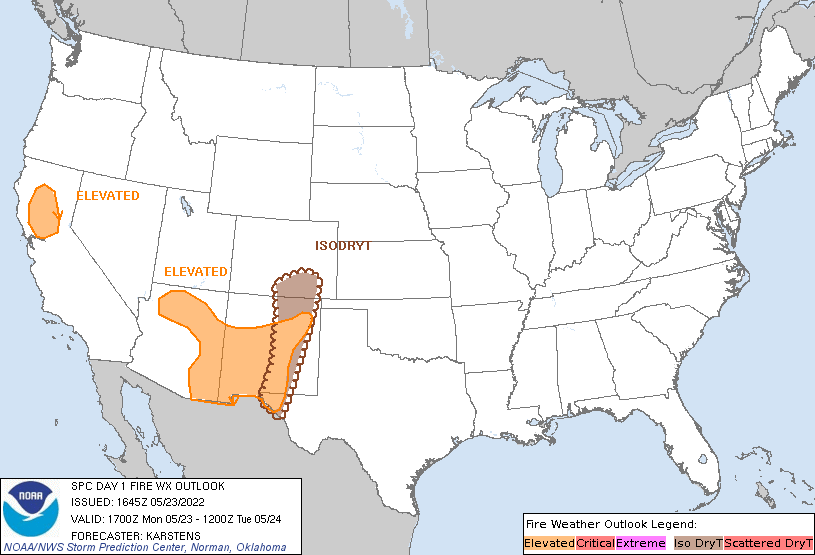
Elevated fire-weather conditions are possible in the Sacramento
Valley this afternoon, as enhanced northerly mid-level flow over the
region mixes toward the surface, resulting in sustained winds of
15-20 mph and RH values into the teens. The persistent dry pattern
across the region is resulting in increasing fuel receptiveness,
with a notable continued upward trend in ERC percentages being
observed (now exceeding 80%). The elevated area has been confined to
areas where fuels appear to be receptive to large-fire spread,
particularly along the adjacent foothills.
Otherwise, the balance of the previous forecast remains on track.
See the discussion below for more details.
..Karstens.. 05/23/2022
.PREV DISCUSSION... /ISSUED 1248 AM CDT Mon May 23 2022/
...Synopsis...
Fire weather concerns will increase this afternoon across parts of
the Southwest and southern High Plains, driven by both dry/windy
conditions and the potential for isolated dry thunderstorms.
Early-morning satellite imagery shows evidence of broad-scale ascent
over the High Plains ahead of an approaching upper-level disturbance
(currently over northern Mexico). The overall upper-level pattern is
forecast amplify over the next 24 hours, which will support the
development of a surface cyclone over the southern High Plains and
increase thunderstorm chances east of the Rockies.
...Southwest...
Modest pressure falls are noted at several surface stations across
NM and adjacent areas of TX, CO, and OK. This trend will continue
through the day as a surface low deepens over the southern High
Plains, augmenting pressure-gradient winds in the process. Ensemble
guidance maintains reasonably high probability for 15-20 mph winds
with RH values falling into the 10-15% range by mid afternoon. As
such, widespread elevated conditions are expected from northern and
eastern AZ into central NM. Areas of critical conditions are
possible, especially along the I-25 corridor in southern NM where
the potential for sustained 20+ mph winds is highest based on
drier/windier solutions. However, spread in deterministic guidance
and poor fuel loading across the desert terrain limit confidence in
sustaining widespread critical conditions. Confidence in the
coverage and duration of the wind-driven fire weather threat is also
limited across northern NM due to the potential for widespread
clouds and scattered showers.
...Southern High Plains/Dry Thunderstorms...
00 UTC soundings across NM and TX reveal the onset of low to
mid-level moisture return into the region. This trend will continue
for the next 24 hours with PWAT values between 0.5 to 1.0 expected
across central NM to west TX by this afternoon. Thunderstorms
developing off the terrain of the southern Rockies will likely
mature within this moisture gradient and over a region with
receptive fuels. Dry sub-cloud layers and fast (25-30 knot) storm
motions will support a dry-lightning threat with initial
thunderstorm activity. Rainfall rates will intensify as storms move
to the east into the better moisture, so the spatial extent of the
dry lightning potential may be limited to a narrow strip across
eastern NM into far southeast CO.
...Please see www.spc.noaa.gov/fire for graphic product...