NOVEMBER 20, 1989 DERECHO
"The Mid-Atlantic Low Dewpoint Derecho of November 20, 1989"
A line of thunderstorms formed along a cold front over north central Pennsylvania late in the afternoon of Monday, November 20, 1989. The storms built south along the front as it accelerated east-southeast across the remainder of Pennsylvania, southeastern New York, New Jersey, and adjacent parts of Maryland and Delaware that evening. The squall line produced a continuous swath of damaging wind that extended more than 250 miles from the Allegheny Mountains to the New Jersey coast and Long Island. Maximum wind gusts commonly exceeded severe limits (58 mph), and numerous measured gusts greater than 70 mph were recorded. In central Pennsylvania, peak gusts of 85 mph and 86 mph, respectively, occurred at University Park Airport, near State College, and at Capital City Airport, near Harrisburg. Closer to the Maryland border, 83 mph and 85 mph gusts, respectively, swept Chambersburg and York. Similar winds affected much of New Jersey at bit later in the evening, with an 86 mph gust reported in Hammonton, in the southern part of the state (Figure 1). The high winds persisted for up to a half hour at some locations.
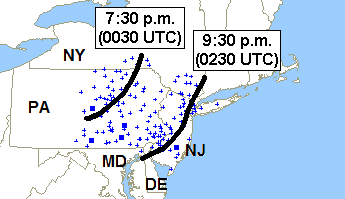
Figure 1. Storm reports showing general area affected by the November 20, 1989 derecho. Black curves are the approximate locations of derecho convective system gust front at 7:30 and 9:30 p.m. EST November 20 (0030 and 0230 UTC November 21). Blue crosses denote reported wind damage and / or measured severe gusts (greater than or equal to 58 mph); blue squares, measured wind gusts greater than 80 mph. Reports are for the 12-hour period from 1:00 p.m. EST (1800 UTC) Monday, November 20 to 1:00 a.m. EST (0600 UTC) Tuesday, November 21.
Soon after the first thunderstorms formed, outflow winds blew roofs off homes and buildings in Bloomsburg, Danville, Spring Mills, and Williamsport, in central Pennsylvania. The winds also unroofed a church in Watsonville, and overturned airplanes at the airport in Lancaster. Countless large trees were toppled, many, unfortunately, onto nearby houses and cars. Several people were injured in vehicles hit by falling trees. About an hour later, in the eastern part of the state, roofs were blown off apartment buildings in Pottstown and Royersford, and homes lost roofs in Doylestown and Phoenixville. A shopping center roof was partially removed in Dublin, and a theatre marque was torn off in Germantown. In southeastern New York, storm winds picked up a car and blew it into a tractor trailer in Fishkill. Farther south, a steeple was blown off a church in Trenton, New Jersey, and the roof of a high-rise apartment building was blown off in neighboring Burlington County. A falling tree seriously injured a man in Princeton. In all, storm winds likely accounted for more than $20 million in damage in Pennsylvania, New Jersey, and New York; additional damage occurred across northern parts of Delaware and Maryland.
The most unusual aspect of this event, aside from its geographical location and the time of year, was the fact that the derecho occurred in an environment with surface dewpoints in the mid 30s (°F; Figure 2). Because of the very limited moisture, precipitation from the derecho-producing storms was scant; on radar, the activity appeared weak and disorganized. Thunderstorm echo tops, typically on the order of 50,000 ft (15.2 km) in most derecho-producing convective systems, remained at or below 20,000 ft (7 km). Maximum radar reflectivities were less than 30 dBZ --- well below the average intensity of even ordinary thunderstorms.
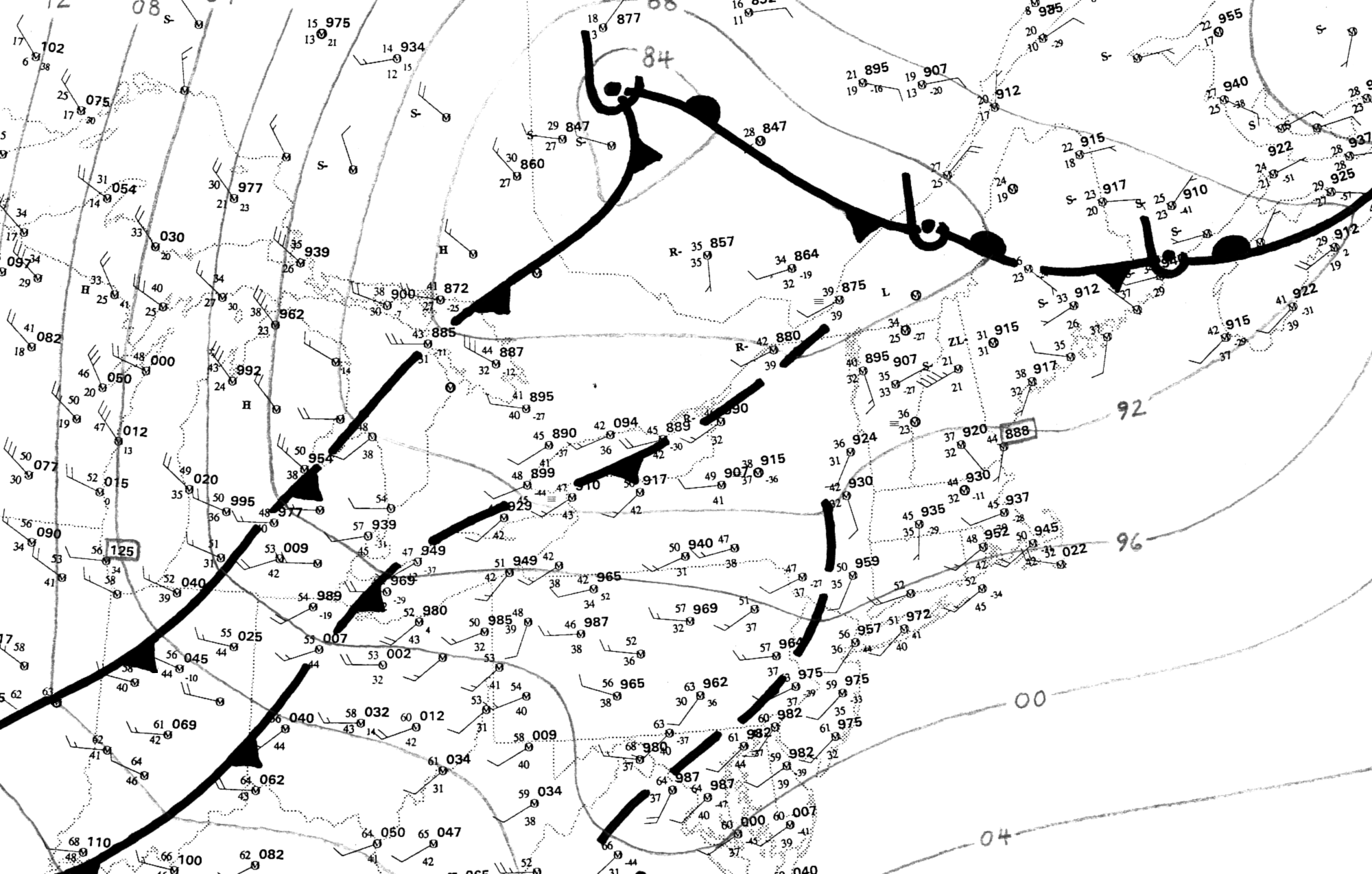
Figure 2. Manual surface analysis for part of the northeastern United States and adjacent Canada, valid 1:00 p.m. EST (1800 UTC) November 20, 1989. Conventional frontal symbols and station plots, with temperature and dewpoint (°F) to left of station circle, pressure (mb) to right. Wind direction and speed given by lines and barbs; full barb = 10 knots (1 knot = 1.15 mph). Isobar interval 4 mb. From Corfidi (2003).
The environment across the mid-Atlantic region on the afternoon of 20 November was characterized by very fast, largely unidirectional west-northwesterly flow in advance of a strong disturbance over the upper Great Lakes (Figure 3). Dry, modified polar air was present at the surface over Pennsylvania and New York, ahead of the disturbance's associated cold front (Figure 2). Because moisture was sparse, atmospheric buoyancy remained weak despite the presence of relatively cool air at mid-levels. Nevertheless, feeble as it was, the instability proved sufficient to support a line of high-based, low-topped thunderstorms along the front, given the sustained source of uplift provided by the boundary, and the presence of seasonably warm air (temperatures in the mid 60s °F) ahead of it.
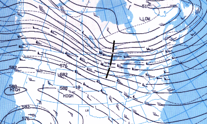
Figure 3. 500 mb (approximately 18,000 foot) upper air analysis for part of the United States and adjacent Canada valid 7:00 a.m. EST (1200 UTC) November 20, 1989. Black lines are contours of the 500 mb pressure surface, labeled in decameters (e.g., "576" = 5,760 meters or 18,900 feet). Wind flow is parallel to the contours and depicted at radiosonde observation sites in the form of "barbs" and "flags;" full barb = 10 kts (1.15 mph); flag = 50 kts (58 mph). Thin dashed lines are isotherms (°C; e.g., -10 = minus 10 °C). Heavy dashed line over the Upper Great Lakes marks the axis of the upper-level disturbance (shortwave trough) mentioned in the text.
The shallow convection proved efficient in mixing the fast upper tropospheric flow down to the surface. Surface winds likely were further enhanced by evaporative cooling that occurred as rain fell into the deep layer of dry air that existed beneath the storms, fostering the formation of microbursts. Indeed, the thermodynamic environment --- with "steep" low-level lapse rates (see Derechos and Heat waves) augmented by downslope warming in the westerly flow east of the Appalachians --- was more akin to that commonly present on a warm summer afternoon with isolated microbursts over the desert Southwest than to a fall evening in the Northeast. That the high wind gusts observed may have been due, in part, to microbursts, is also supported by the very rapid forward motion of the convective system --- 60 mph --- 20 mph faster than the mean cloud-layer flow.
The November 20, 1989 Mid-Atlantic derecho was one of the more unusual cool-season events observed in recent decades. It illustrates that convective systems capable of widespread damaging wind may occur anywhere and at any time --- even in moisture-starved environments --- when both the background flow and atmospheric forcing for ascent are strong, and when low-level lapse rates are steep. Just four days before the November 20, 1989 derecho, a more conventional (moisture-wise) cool-season serial derecho affected much the same region on November 16, 1989. That system produced fewer measured severe wind gusts, but a broader swath of damage that extended from Virginia to New England.
_____________________________________________________________________________
Additional information:
Corfidi et al. 2006
Storm Data, November 1989