MAY 8, 2009
DERECHO
"The 'Super Derecho' of May 2009"
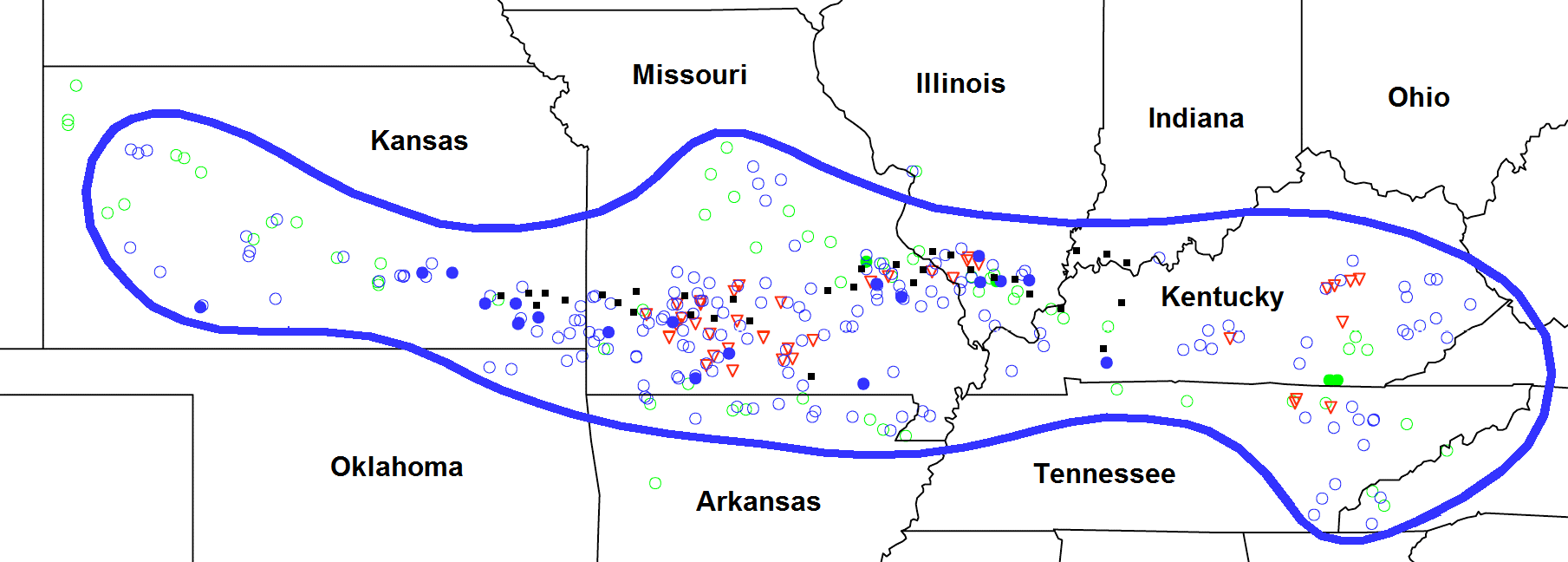
Figure 1. Area affected by and severe weather reports associated with the May 8, 2009 "Super Derecho" convective system. Area affected outlined in blue. Severe reports are for the period from 10:00 p.m. CDT Thursday, May 7 (0300 UTC May 8) to 6:00 p.m. CDT (2300 UTC) Friday, May 8. Wind damage or wind gusts ≥ 50 kts (58 mph), open blue circles; estimated or measured wind gusts ≥ 65 kts (74 mph), filled blue circles; hail ≥ 0.75 inches, open green circles; hail ≥ 2.0 inches, filled green circles; tornadoes, red triangles. Flash flooding (by county) denoted by black squares. Area of most intense wind damage is approximated by band of filled blue circles extending from southeast Kansas through southern Missouri into southern Illinois.
The May 8, 2009 "Super Derecho" was one of the most intense and unusual derechos ever observed. The wind storm produced significant and often continuous damage over a broad swath from the high plains of western Kansas to the foothills of the Appalachians in eastern Kentucky (Figure 1). Multiple wind gusts in excess of 70 mph and isolated gusts over 90 mph were measured along its path. The associated convective system exhibited numerous small-scale bow echoes, a well-defined larger-scale bow, and numerous small-scale vortices with tornadoes. In addition, flash flooding was widespread on the northern fringe of the system, especially in Missouri. But what made the event most unique was the appearance of an unusually strong, long-lived, larger-scale circulation known as a mesoscale convective vortex, or MCV. This feature was accompanied by a band of intense surface winds and tornadoes that occurred independent of the severe weather directly associated with the large-scale bow.
As significant as the "Super Derecho" was, the parent convective system arose from very humble beginnings. Its origin may be traced to the development of shallow, high-based cumuliform clouds over northeast Colorado and southwest Nebraska on the afternoon of Thursday, May 7. The clouds formed in an area of persistent ascent over the central High Plains. This ascent appeared to be associated with both a stationary mountain wave in the lee of the Rockies, and with a disturbance that was approaching in the west-northwestly jet stream flow aloft. Because moisture was sparse and because winds were not favorable for storm development, the clouds did not achieve substantial vertical development. They did, however, grow sufficiently to produce light rain showers. Most of this precipitation evaporated before reaching the ground. In so doing, the rain chilled the sub-cloud layer and produced an area of relatively cool air at the surface. Given the direction of the prevailing flow, this cool air dome expanded preferentially east-southeast across eastern Colorado through the evening. As the leading edge of the cool outflow continued east-southeastward, it served as a focus for deeper convective development and, ultimately, thunderstorm intitiation, over far eastern Colorado and the northwest corner of Kansas around 10:00 p.m. CDT (Figure 2). The intensification of the convection may be attributed, in part, to the outflow encountering increasing low-level moisture that was beginning to spread north into the area from Texas and Oklahoma.
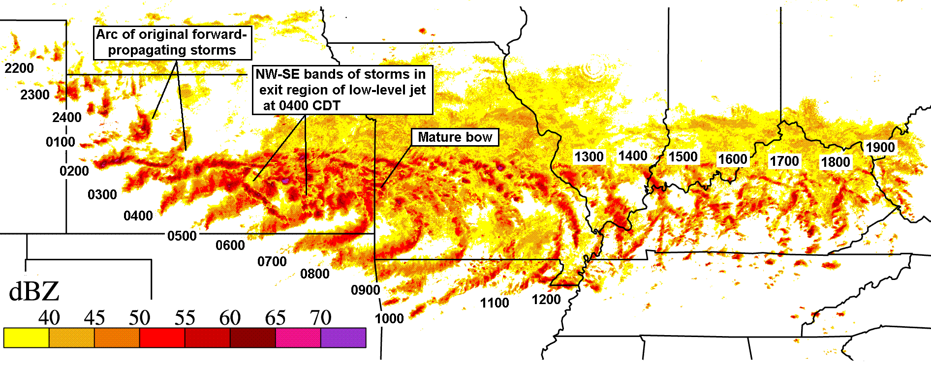
Figure 2. Composite display of hourly radar reflectivity imagery, showing development and evolution of the May 8, 2009 derecho-producing convective system. Time is CDT, and ranges from 10:00 p.m. Thursday, May 7 (0300 UTC May 8, far left) to 7:00 p.m. Friday, May 8 (0000 UTC May 9, far right). Intensity scale (dBZ) at lower left. (Modified from base image by G. Carbin, NOAA Storm Prediction Center)
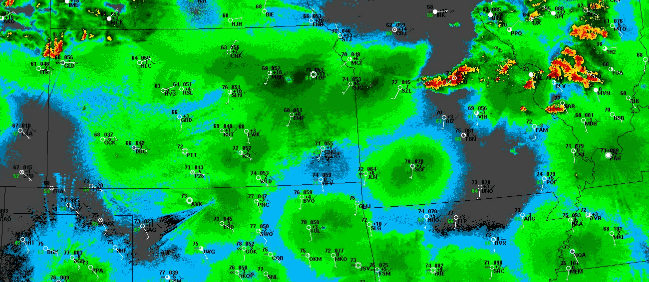
Figure 3. Fifteen-hour composite radar reflectivity loop showing developmental and mature stages of the May 8, 2009 derecho-producing convective system. The "ping-pong" animation begins at 11:00 p.m. CDT Thursday, May 7 (0400 UTC May 8) and ends at 2:00 p.m. CDT (1900 UTC) Friday, May 8. Large green areas that surround radar sites during first half of loop are "ground clutter" patterns that arise from radar beams being bent downward by nocturnal temperature inversions. Reflectivity intensity scale not shown, but stronger returns (higher dBZ values) depicted in orange and red. Surface data also shown, using conventional format with standard three-letter station identifiers (temperature / dew point (°F) on left, pressure / pressure tendency (mb) on right; white lines / barbs depict wind direction and speed (knots; one full barb = 10 knots = 11.5 mph)).
The thunderstorms grew steadily as they moved and developed east-southeast across western Kansas. Golfball-sized hail fell near Goodland shortly after 11:00 p.m. (CDT), and a 67 mph wind gust struck Oakley around midnight. The storm that produced the gust at Oakley evolved into a small bow echo as it continued southeast toward the town of Hays. The storms grew further in size and strength as their gust fronts expanded and merged, encouraging forward-propagation (i.e., new cell development on the downwind side of the gust front) toward the Great Bend and Dodge City areas between 2:00 and 3:00 a.m. on Friday, May 8th. Wind gusts to 70 mph and penny-sized hail pelted Great Bend, and an 80 mph gust was recorded in Clark County, south of Dodge City. Truly explosive development, however, occurred after 3:00 a.m. as the storms accelerated east-southeastward and merged with bands of new storms that very rapidly erupted over south central Kansas. The latter storms appear as short, northwest-southeast oriented lines in Figures 2 (at 4:00 a.m.) and 3, and appeared to be associated with uplift on the leading edge of an unusually broad, rapidly intensifying, and moisture-rich low-level jet. Several large supercells emerged from the consolidating storms. These produced numerous damaging gusts over south central Kansas between 4:00 and 5:00 a.m., including an 81 mph gust in El Dorado. One person was injured when their vehicle was rolled by high winds on the Kansas Turnpike. The damage became more intense and widespread as a larger scale bow echo began to evolve east of Wichita after 5:00 a.m. Eighty mph winds hit the Eureka and Buxton areas, and a woman died in New Albany when high winds destroyed her mobile home. A semi-trailer was overturned near Independence, and buildings in the area suffered major damage. At the same time, the storms dropped up to four inches of rain in less than an hour. Motorists were stranded by high water in Coffeyville, and flooding forced road closures in Montgomery and several neighboring counties in southeast Kansas.
The damage swath broadened and became nearly continuous as the now mature large-scale bow accelerated east-southeast into southwest Missouri and northeast Oklahoma around 7:00 a.m. Countless trees and power lines were downed, and 80-100 mph straight-line winds toppled the transmitting tower of KSN-TV in Joplin (Figure 4). The tower fell onto part of the studio building, forcing the station to remain off-air for several weeks. Roof and home damage was widespread. Numerous embedded tornadoes, including six rated EF-2 and one rated EF-3, added to the destruction in Missouri. One of the tornadoes killed a person near the town of Charity, and another injured two people near Mountain View. An EF-2 storm cut a path up to one-half mile wide and 25 miles long in Howell, Shannon, and Texas Counties. Even more significantly, while damaging winds continued to accompany the leading edge of the bow southward into Arkansas, a band of more intense winds developed in association with the previously-mentioned mesoscale convective vortex that evolved on the north end of the bow. This persistent vortex resembled the core of a tropical storm, complete with a small "eye," and produced sustained 70-90 mph winds as it swept east across southern Missouri between 8:00 a.m. and noon (Figures 3 and 4). The nearly continuous damage swath from such a meso-vortex was unprecedented. The winds were strongest on the south side of the circulation and were responsible for at least two deaths, numerous injuries, and widespread structural damage. Metal beams from a damaged factory building crushed cars near Sedgewickville in Bollinger County, and two buildings were destroyed in neighboring Perry County. At some locations, severe wind gusts lasted 45 minutes, and in forested areas, 80% of the trees were flattened. Flash flooding largely associated with storms on the northern fringe of the vortex required water rescues in St. Francois and Ste. Genevieve Counties.
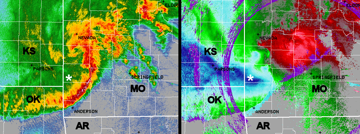
Figure 4. Springfield, Missouri NWS radar reflectivity (left) and velocity (right) views made at 7:30 a.m. CDT Friday, May 8th as the derecho-producing convective system entered its most active and highly-organized phase of development. State borders depicted by heavy white lines (with conventional, two-letter state abbreviations); county borders by thin white lines. White asterisk denotes the city of Joplin, Missouri, where intense winds (dark blue band in right image) behind the apex of the large-scale bow echo produced significant damage. North of Joplin, about two-thirds of the way to Nevada, Missouri, the hooked-shaped region in the reflectivity data marks the early stage of development of the mesoscale convective vortex (and its "eye") mentioned in the text. Smaller scale vortices also are apparent along the bow echo between the mesoscale vortex and Joplin.
The meso-vortex moved east into southern Illinois and western Kentucky shortly after noon, where the destruction continued (Figures 3 and 5). Franklin, Jackson, and Williamson Counties in Illinois were especially hard-hit. The city of Carbondale was nearly impassable because of fallen trees and debris, and 34 properties were deemed total losses. The campus of Southern Illinois University suffered extensive damage, with nearly 100 windows blown out of residence halls. An unofficial gust to 106 mph was recorded on the roof of the Carbondale airport. A falling tree limb killed a man in Murphysboro, and another man was injured seriously when the semi-trailer he was driving was overturned on Interstate 57. Fallen trees and power lines seriously impacted emergency response. Although the circulation finally weakened upon reaching southwest Indiana around 3:00 p.m. CDT (4:00 p.m. EDT), flash flooding on its northern fringe necessitated water rescues in the Evansville area, and an associated valve failure caused sewer water to back up into a school. The vortex feature remained discernible as it continued east to the Louisville, Kentucky area around 5:00 p.m. EDT.
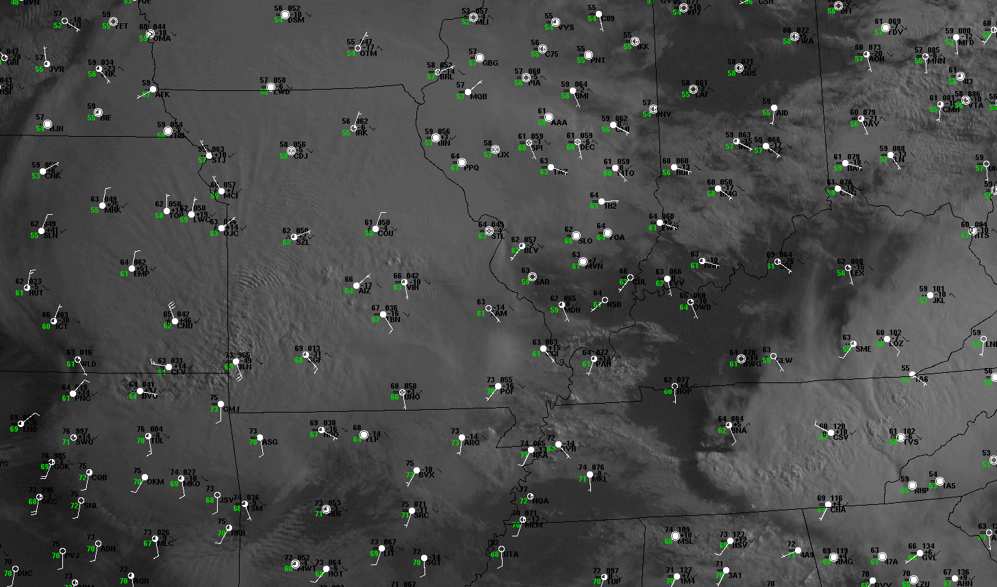
Figure 5. Ten-hour visible data satellite loop showing the mature and weakening stages of the May 8, 2009 derecho-producing convective system. The "ping-pong" animation begins at 7:15 a.m. and ends at 5:15 p.m. CDT Friday, May 8th. Surface data also shown, using same conventional station plot format as in Figure 3. The deepest clouds of the convective system assume a spiral shape over eastern Missouri and southern Illinois by midday as the shallower convection dissipates and the anvil canopy thins. Undulated cloud tops over western Missouri at the start of the loop reflect the presence of gravity waves that were generated when the powerful storm updrafts associated with the mesoscale vortex impinged upon the tropopause.
The original large scale bow echo became less organized as it exited Missouri. But clusters and bands of new storms continued to form in a discontinuous fashion ahead of the original bow over Kentucky and northern Tennessee through the afternoon, largely in response to surface heating (Figure 5). Although the convective system never assumed the high degree of organization that had existed earlier in the day, several bowing line segments and numerous supercells produced damaging wind and tornadoes. This activity spread eastward into southwest Virginia, southern West Virginia, and east Tennessee by mid-evening. Two people died when a tornado flipped their mobile home near Kirksville, Kentucky, and several injuries occurred in the nearby town of Waco. Large hail also occurred in eastern Kentucky and Tennessee. This was the first appearance of hail with the system since that which fell during its early stages of development in Kansas, and several swaths that occurred during the morning in Missouri. The last severe weather event more or less directly attributable to the derecho-producing storm system occurred shortly before midnight (EDT), when a possible tornado destroyed a mobile home and damaged several buildings in the town of Ennice in the northwest corner of North Carolina.
In summary, the "Super Derecho" of May 2009 traveled more than a thousand miles in twenty-four hours, causing untold millions of dollars of damage, numerous injuries, and several deaths. It produced widespread destruction, especially over southeast Kansas, southern Missouri, and southern Illinois, and was responsible for electrical outages that affected many millions. Power in some areas was not restored for nearly a week. The associated convective system also produced widespread flash flooding. Of particular note was the long-lived mesoscale convective vortex spawned by the parent convective system. This feature produced an extensive swath of intense damage independent of that caused by the more traditional large-scale bow echo with which it was associated.
Despite the outstanding nature of this event, the associated convective system arose from a seemingly benign environment that did not display some of the characteristics most often associated with high wind-producing storms (e.g., a pre-existing west-east front along which the storms develop and move, and an abundance of dry air in the area of most intense storm development to encourage the formation of evaporatively-cooled downdrafts). The "Super Derecho" likely will be a focus of study for some time to come so that the factors that led to its development and intensity can be better understood.
More information about the May 8, 2009 "Super Derecho" is available on this site that contains presentations made at the Cooperative Institute for Precipitation System's 2011 Bow Echo Workshop (scroll to Session 1D). The workshop was sponsored by the National Weather Service and Saint Louis University.
_____________________________________________________________________________
[Mike Coniglio and Jack Kain, NOAA National Severe Storms Laboratory, provided input on this event].
Additional information:
Corfidi et al. 2010
Coniglio et al. 2011