MAY 4-5, 1989
DERECHO
"The Texas Derecho of 1989"
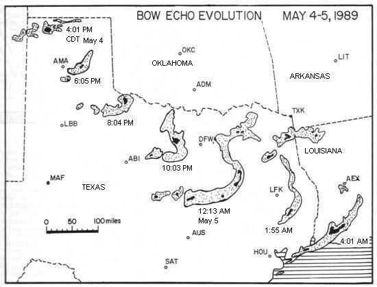
Figure 1. Evolution of stronger radar echoes (reflectivity images from heavy rain and hail) associated with the May 4-5, 1989 derecho. Radar images are shown at approximately two-hour intervals in Central Daylight Time. (Modified from Smith 1990)
On Thursday afternoon, May 4th, 1989, an isolated supercell thunderstorm formed over southeastern Colorado and moved southeast into the Texas Panhandle. As the supercell moved across the Amarillo, Texas area (about 5-6 p.m. CDT) it began to evolve into a bow echo (see Figure 1). This bow echo continued southeast and grew in scale, reaching its maximum size over the region from the Dallas/Ft. Worth metro area southward into central Texas. The storm system moved into southwest Louisiana around 3 a.m. CDT May 5th and finally dissipated over southeast Louisiana around 7 a.m. local time.
As the storm system shown in Figure 1 moved rapidly southeast across the southern Plains, it created a significant derecho event (Figure 2). At some locations in northwest Texas the derecho winds lasted 20 to 30 minutes. Measured wind gusts reached 100 mph at the U.S. Department of Energy's Pantex Plant northeast of Amarillo, 75 mph at Brice, and 86 mph at the Childress airport (Figure 2). Over 100 mobile homes were damaged, overturned, or destroyed. Four tractor trailers were blown over, and a commercial radio transmitting tower was blown down. In addition, many power lines and utility poles were toppled, buildings were damaged, and barns were destroyed. One person was injured seriously in a collapsed barn.
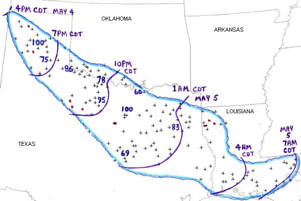
Figure 2. Area affected by the May 4-5, 1989 derecho (outlined in blue). Curved purple lines represent locations of gust front at three hourly intervals. Measured wind gusts are plotted in mph. "+" symbols indicate locations of wind damage or estimated wind gusts above severe limits (58 mph or greater). Red dots and lines denote tornadoes.
Although the thunderstorms associated with the derecho passed south of Oklahoma, wind damage occurred over parts of southwest Oklahoma because the derecho gust front expanded well beyond the actual thunderstorms. The primary path of the storms and the derecho continued southeast across north central and east Texas, where measured wind gusts reached 78 mph at the Wichita Falls airport, 95 mph at a power plant just north of Graham, 100 mph at a television station in Ft. Worth, and 83 mph at the Tyler airport (Figure 2). In this part of Texas, literally thousands of businesses, homes, and mobile homes were damaged, with over 100 structures (mostly mobile homes) destroyed. Two people were killed and several dozen injured. Some of the worst damage occurred in Young, Palo Pinto, Hood, Tarrant, Johnson, and McLennon Counties. Over 250,000 customers lost electrical power in Tarrant County (the Ft. Worth metropolitan area) alone.
The derecho continued to cause damage to trees and buildings as it crossed southern Louisiana during the early morning of May 5th. The storm system finally weakened near New Orleans around 7 a.m. CDT.
In summary, this derecho traveled 900 miles in 15 hours. Most of its track and the most intense damage occurred over northern and eastern Texas. It began in the semi-arid region of the northwest Texas Panhandle and surged southeast at a speed greater than 60 mph for 700 miles before reaching the densely forested region of southeast Texas about 11 hours later. Many thousands of Texans were affected by this intense derecho, and many still remember it as "The Great Storm of 1989."
_____________________________________________________________________________
Additional information:
Smith 1990
Storm Data, May 1989