MAY 31, 1994 DERECHO
"The Utah / Wyoming Derecho of May 31, 1994"
On Tuesday, May 31, 1994, an area of thunderstorms that formed before dawn over southern Nevada intensified as it moved northeast across western and
and central Utah during the mid to late morning. The storms assumed a broad, arc-shaped configuration and accelerated northeast across northern
and eastern Utah during the afternoon, reaching southwest Wyoming, southeast Idaho, and northwest Colorado later in the day. The convective
system finally weakened over central Wyoming around sunset, after having produced a nearly continuous, 340 mile-long swath of damaging wind that
included numerous measured gusts well above severe limits (Figure 1).

Figure 1. Storm reports showing general area affected by the May 31, 1994 derecho. Black curves are the approximate two-hourly (MDT) locations of the derecho-producing convective system gust front. Small blue dots denote measured "near severe" (43-49 kts) convective gusts; large red dots, measured severe (50-64 kts) convective gusts; and red squares, "significant severe" (greater than 64 kt) convective gusts and/or reported wind damage. Reports are for the 12-hour period from 6:00 a.m. MDT (1200 UTC) Tuesday, May 31 to 6:00 p.m. MDT (1200 UTC) Wednesday June 1.
While the convectively induced wind storm easily qualified as a derecho, what was most unusual about the event was its location over the
Intermountain West. Derecho-producing convective systems are relatively uncommon west of the Rocky Mountains because sufficient moisture
typically is not present in the lower troposphere to support establishment of the strong, long-lived cold pools that foster the regenerative
thunderstorm activity of derechos. In this case, moisture was quite limited by central and eastern United States standards (surface
dewpoint temperatures were in the mid 40s to low 50s °F; Figure 2). It was, nevertheless, enough to support derecho development given the presence
of other meteorological factors (discussed below) that were favorable for regenerative storms. The event also was unusual in that the
convection crossed areas of significantly elevated terrain without dissipating. Terrain irregularities can negatively impact the organization
and sustenance of thunderstorms, especially those strongly dependent on cold pools for development and organization.

Figure 2. Visible data satellite image at 2:00 p.m. MDT (2000 UTC) May 31, 1994 showing leading edge of derecho-producing convective system marked by arc of towering cumulus and cumulonimbus clouds extending from near the Great Salt Lake southward into south central Utah. Surface observations shown using conventional format, with temperature (red) and dew point (green), both in °F. Cyan lines and barbs depict wind direction and speed, respectively, in knots; one full barb = 10 knots = 11.5 mph.
The strongest measured wind gust in the event, 140 mph, was recorded on Camelback Mountain in the Dugway Proving Ground southwest of Salt
Lake City. The high winds damaged many structures at the Tooele Army Depot, and blew empty storage containers the size of semi-trailers off railroad
flat cars. A chicken farm in Lakeshore, Utah received $400,000 in structural damage. Some of the most intense damage, however, occurred farther
east. Winds gusted to 105 mph in the Provo area, toppling thousands of trees and damaging many homes and buildings, some significantly. Damage to
the campus of Brigham Young University alone totalled $1 million. Sixteen people were injured in Provo, including a girl hit by a falling air conditioner.
On the south shore of the Great Salt Lake, part of the roof of the Saltair Pavilion was destroyed, with the damage estimated at $270,000. The peak
gust at Salt Lake International Airport was 62 mph, where a DC-3 airplane was moved one quarter mile down the runway. At least 20 utility poles caught
fire as the wind severed electrical lines in Salt Lake City.
The convective system somewhat weakened upon crossing the Wasatch Mountain east of Salt Lake City. However, severe gusts were recorded at
both Heber City, Utah (70 mph) and Evanston, Wyoming (60 kts). Observed wind gusts increased again as the storms continued northeast to the
Green River area, with severe or stronger gusts recorded on both sides of the Uinta Mountains, as well as pea-sized hail. In southwest Wyoming, roofs were
blown off houses and windows were blown out of cars in Rock Springs. At the Flaming Gorge Reservoir south of Rock Springs, boat docks were blown
ashore, and winds remained at or above severe levels for up to one hour.
The animated visible data satellite imagery in Figure 3 (the same loop appears here in Derecho Development)
shows the motion of the convective system from its mid-morning origin in far eastern Nevada to its demise over central Wyoming and northwest Colorado late
in the day. Careful observation of the loop reveals that individual storms (bright, clumpy, cumulonimbus clouds) form repeatedly along the leading
edge of the arc-shaped, northeast-moving gust front as dissipating, high-level clouds (fibrous cirrus "anvils") produced by earlier updrafts are left
behind. The trailing high-level clouds suggest that the convective system was moving faster than the mean wind. This was indeed the case, as the development
(propagation) of new storms was very rapid and occurred in the same downwind (northeasterly) direction that the storms were carried by the mean environmental flow.
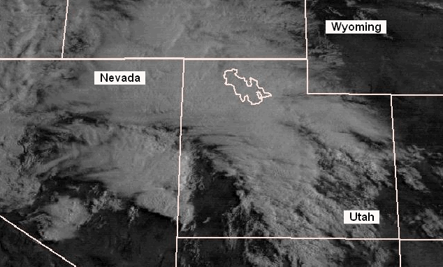
Figure 3. Eight-hour visible data satellite loop showing the development and evolution of the May 31, 1994 derecho-producing convective system. "Ping-pong" animation begins at 9:00 a.m. MDT (1500 UTC) and ends at 5:00 p.m. MDT (2300 UTC).
As already mentioned, the May 31, 1994 derecho was unusual in being one of the relatively few significant events to have been documented west of the Rockies.
A similar, though somewhat weaker derecho affected much of the same region on June 1, 2002. The associated convective systems in both cases occurred
in environments characterized by strong forcing for ascent in the mid to upper troposphere. This forcing was in the form of a strong jet stream disturbance
or "trough" that encouraged the development of thunderstorms as it approached the Great Basin --- despite the comparatively dry environment relative to that
commonly present with with derechos east of the Rockies. The jet stream disturbances also were "negatively-tilted," meaning that their axes were oriented
northwest to southeast (Figure 4). Such an orientation fosters strong vertical motion in the lower atmosphere that can lead to cloud formation and thunderstorm
development when thermodynamic conditions or moisture availability are not very favorable for storms. Negative-tilt troughs commonly are associated with severe
weather events in the western United States, and with cool-season severe weather outbreaks over the central and eastern states.

Figure 4. 500 mb (approximately 18,000' altitude) upper air analysis over the western United States and eastern Pacific, valid 6:00 am MDT (1200 UTC) May 31, 1994. Black lines are contours of the 500 mb pressure surface, labeled in decameters (e.g., "570" = 5,700 meters or 18,700 feet). Wind flow is parallel to the contours and depicted at radiosonde observation sites in the form of barbs and flags; full barb = 10 kts (11.5 mph); flag = 50 kts (58 mph). Thin dashed lines are isotherms (°C; e.g., -10 = minus 10 °C). Heavy dashed line over the Lower Colorado Valley marks the axis of the "negative-tilt" trough mentioned in the text. Band of 50 kt southerly flow over Nevada in this early-day analysis moved east into Utah later in the day as the trough continued northeastward. Area thermodynamic soundings (not shown) indicate that some of this flow mixed down to the surface in thunderstorm downdrafts and, along with evaporative cooling, contributed to the very strong surface gusts observed.
Yet another unusual aspect of the May 31 derecho was that it occurred behind rather than along or ahead of the cold front that moved northeast across
the region in association with the upper trough. The cold front is marked roughly by the band of cloudiness lying east and north of the derecho-producing
squall line in the satellite loop in Figure 2. Surface temperatures over the Great Basin had been well above normal for several days prior to the
event as a large, warm high pressure system became stationary over the region. As is usual in such a pattern over the southern Plateau
(see Derechos and Heat waves), temperatures decreased fairly rapidly with height; i.e., the "lapse rate" or
vertical decrease of temperature with height was "steep." But this pre-cold frontal air mass also was very dry; too dry to support more than widely scattered,
high-based cumulus clouds.
As the cold front moved across Utah early on May 31, it ushered in a more moist low-level environment (of Pacific origin) than that which preceded it. This
moisture was modest by eastern United States standards; dewpoints rose only into the mid 40s to low 50s. But arrival of this moisture allowed convection
that formed in response to surface heating along a secondary wind shift line (located near the Nevada-Utah border at the start of the satellite loop) to
sufficiently deepen to attain thunderstorm strength. Because lapse rates remained steep in the low to mid troposphere, and because appreciably-strengthened
environmental flow accompanied the trough (Figure 3), the storms became efficient downdraft-producers. The unidirectional nature of the deep southwest flow ahead
of the trough encouraged the downdrafts to surge northeastward in a unified fashion, resulting in an organized severe wind event.
In summary, the May 31, 1994 Utah / Wyoming derecho is a good example of a hybrid-type event occurring in an environment with very limited moisture. In such cases, strong forcing for ascent, fast environmental flow, and steep low- to mid-level lapse rates compensate for relatively limited moisture availability to yield long-lived damaging wind events.
_____________________________________________________________________________
[Mark Darrow provided the images used to create the satellite animation for this event.]
Additional information:
Corfidi et al. 2006
Corfidi et al. 2016
Storm Data, May 1994