MAY 30-31, 1998
DERECHO
"The Southern Great Lakes Derecho of 1998"
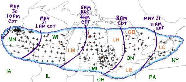
Figure 1. Area affected by the May 30-31, 1998 derecho event (outlined in blue). Curved purple lines represent the approximate locations of the "gust front" at three hourly intervals. "+" symbols indicate the locations of wind damage or wind gusts above severe limits (measured or estimated at 58 mph or greater). Red dots and paths indicate tornadoes.
On Saturday, May 30, 1998 a low pressure system moving toward the northern Plains and Great Lakes posed a threat for severe storms. By late Saturday afternoon, supercell thunderstorms developed over eastern South Dakota, and some began to produce tornadoes. One violent tornado hit Spencer, South Dakota, causing widespread damage and six deaths. However, this localized tornado outbreak in South Dakota would not be the only significant severe weather episode associated with the low pressure system. The storm system also would produce a major derecho event in the Upper Mississippi Valley and southern Great Lakes during the evening and overnight hours of May 30th and May 31st (Figure 1). In addition, on Sunday May 31st, the low produced a third severe weather episode in the northeastern United States, including supercells with strong tornadoes and bow echoes with damaging winds. The following paragraphs, images, and links focus on the second significant severe weather episode, the major derecho event shown in Figure 1.
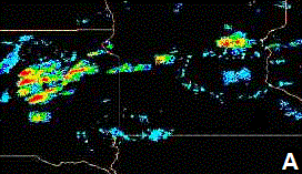
Figure 2. Composite radar reflectivity over parts of the northern Plains at 7 p.m. CDT May 30, 1998 (A), and at 10 p.m. CDT May 30, 1998 (B). (Imagery provided by National Weather Service meteorologist Randy Graham)
During the early evening of Saturday, May 30, the tornado-producing supercells over eastern South Dakota (Figure 2A) merged and became a squall line that moved east into southern Minnesota (Figure 2B). As the squall line crossed southern Minnesota it evolved into a bow echo system that expanded in scale and raced east across the southern Great Lakes before finally dissipating over central New York after sunrise on Sunday, May 31st. This bow echo system produced one of the most dangerous and costly derecho events in the history of the Great Lakes region. The "Southern Great Lakes Derecho of 1998" adversely affected millions of people on the weekend after Memorial Day. Many casualties and record amounts of damage occurred.
A "ping-pong" animation of composite radar imagery showing the development and movement of the bow echo system from southern Minnesota into Lower Michigan appears in Figure 3.
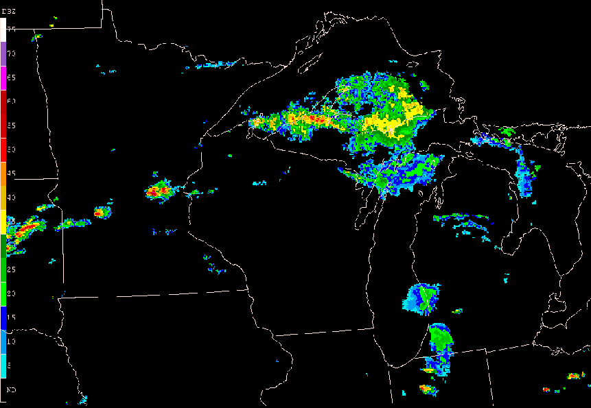
Figure 3. Eleven-hour composite radar base reflectivity loop showing development and evolution of the May 30-31, 1998 derecho-producing convective system. "Ping-pong" animation begins at 7:00 p.m. CDT Saturday, May 30 (0000 UTC May 31) and ends at 6:15 a.m. CDT (1115 UTC) Sunday, May 31. Reflectivity intensity scale at left (dBZ).
...MINNESOTA AND IOWA...
The bow echo system began to produce significant wind damage over south central Minnesota about 10 p.m. CDT Saturday evening (Figures 1 and 2B). As the system moved rapidly eastward it grew south into northern Iowa and caused damaging winds over most of southeast Minnesota and northeast Iowa. Many trees and power lines were blown down and several farm buildings were damaged or destroyed.
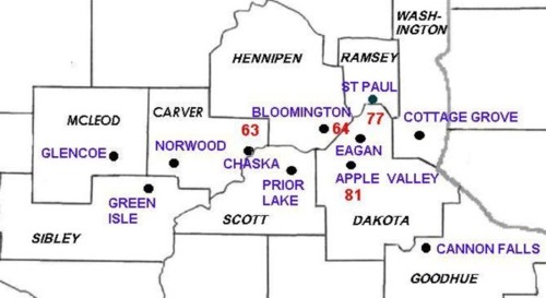
Figure 4. Minnesota counties (in black) and some of the towns and cities (in blue) most severely affected by the derecho of May 30-31, 1998. The red numbers are measured wind gusts in mph.
However, the most intense damage occurred near the northern end of the bow echo system in Minnesota, from Sibley and McLeod Counties eastward across southern portions of the Minneapolis/St. Paul metropolitan area (Figure 4). Along this band, winds greater than 80 mph were measured; in some areas, estimated speeds reached 100 mph. Tens of thousands of trees were blown down, 500,000 customers lost power, two semi-trailer trucks were overturned, two apartment building roofs were blown off, and 100 boats were destroyed. In addition, over 100 homes were destroyed or very badly damaged, and over 2000 others received some damage. Twenty-two people were injured, and damage to property was estimated to be about $48 million in 1998 U.S. dollars...with $35 million dollars of that damage occurring in Dakota County alone.
In summary, while crossing southern Minnesota and northeastern Iowa, the derecho event caused about $50 million in 1998 U.S. dollars of damage, left about 600,000 customers without power, and injured twenty-two people. In some areas, power was not restored until nearly a week after the event.
Additional information on the impact of the May 30-31, 1998 derecho in Minnesota may be found in the review by William E. Togstad of the Minneapolis/St Paul National Weather Service office, available here.
...WISCONSIN...
The derecho was in full force as it entered west central Wisconsin just before midnight CDT. It raced east across the southern two-thirds of the state at a speed of near 60 mph, reaching Lake Michigan in about 3 hours and exiting the southeastern corner of the state by 4 a.m. CDT Sunday, May 31st.
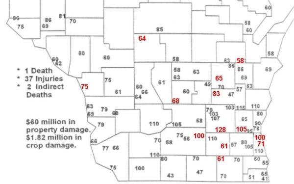
Figure 5. Maximum wind gusts in mph associated with the May 30-31 derecho in Wisconsin. Measured gust values are red and estimated gust values are black [Modified version of a map prepared by National Weather Service meteorologists Rusty Kapela (Sullivan/Milwaukee, WI), Jeff Last (Green Bay, WI), and Todd Shea (LaCrosse, WI)].
As the derecho crossed central and southern Wisconsin, almost every point experienced winds above severe limits (58 mph or greater; Figure 5). Measured and estimated wind gusts from 70 to 100 mph were common in the southern half of the state. Extremely strong measured winds gusts from 100 to 128 mph were recorded in a band from northeast of Madison to the northern part of the Milwaukee metropolitan area. The strong winds knocked down hundreds of power poles and thousands of trees. About 250,000 customers lost electrical power. Some residences and businesses remained without power for five or six days. Affected utilities companies and some emergency managers stated that this was the most damaging and widespread straight-line thunderstorm wind event to affect southern Wisconsin in 100 years. Over 5000 homes, businesses, and farm buildings were damaged and about two dozen homes and businesses were destroyed. Total damage estimates for Wisconsin exceeded $60 million in 1998 U.S. dollars. In Washington County a person was killed when a tree fell through the roof of her home and onto the bed where she was sleeping. Thirty seven other people were injured as the derecho roared through Wisconsin.
Additional information on the May 30-31, 1998 derecho in Wisconsin may be found here, a page maintained by the Sullivan/Milwaukee, Wisconsin National Weather Service office.
...LOWER MICHIGAN...
The leading edge of the derecho reached the eastern shores of Lake Michigan around 4:45 a.m. EDT Sunday and blasted across Lower Michigan at a speed of about 70 mph. It reached the "Thumb" area in a little over 2 hours (Figure 1). Winds of 60 to 90 mph were common; in some areas, winds were estimated to have reached 130 mph (Figure 5). Of all the regions affected by the derecho, the greatest damage and the greatest number of casualties occurred in Lower Michigan. In this region four people were killed and 146 were injured. Total damage was estimated to be $172 million (1998 U.S. dollars). Approximately 250 homes and 34 businesses were destroyed, and over 12,000 homes and 800 businesses were damaged. About 860,000 customers lost electrical power. This was a new historical record, slightly exceeding the number of customers that lost power during the Southern Great Lakes Derecho of 1991. In some locations power was not restored for up to 10 days. For Consumers Energy, the utility company that serves much of western and middle Lower Michigan, this derecho was the most destructive weather event in the company's history. Besides the loss of hundreds of power poles and lines, five of the company's 345-kilovolt transmission towers were blown down between Ludington and Grand Rapids. These massive towers were designed to withstand continuous winds up to 90 mph and gusts to 110 mph.
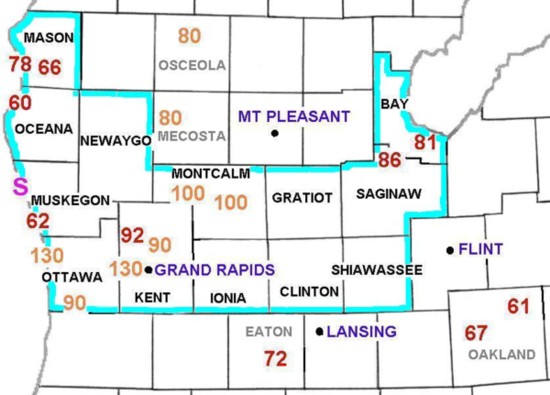
Figure 6. Area of Lower Michigan affected by the worst damage from the May 30-31, 1998 derecho. Red numbers are maximum measured wind gusts in mph. Orange numbers are estimated maximum gusts in mph, based on a damage survey by Grand Rapids NWS Forecast Office meteorologists. Thirteen Michigan counties (noted in black lettering and within light blue border) together were declared a Federal Disaster Area by the Federal Emergency Managers Association. The purple "S" represents where a "seiche" took place on the eastern shore of Lake Michigan.
The most devastated area was central Lower Michigan, where 13 counties were declared a Federal Disaster Area by the Federal Emergency Managers Association (outlined in blue on Figure 6). Some of the towns and communities within the Federal Disaster Area that received the greatest damage included Spring Lake in Ottawa County, and Walker, a western suburb of Grand Rapids, in Kent County. Damage surveys indicated that winds in these towns may have reached 120 to 130 mph. The damage near Cody Lake and Stanton in Montcalm County suggested winds on the order of 100 mph.
Derechos crossing Lake Michigan occasionally produce what is called a seiche (pronounced as "say-sh"). A seiche is a prounounced oscillation of the lake surface. Such oscillations can at times change the water level at a given point by as much as ten feet. The May 30-31, 1998 derecho produced a seiche as the water level rose on the east side of the lake because of the intense westerly winds. At the time the derecho hit the east shore, a tug boat, the Stephen M. Asher, was traveling through a channel between Lake Michigan and White Lake north of Muskegon (the purple "S" in Figure 6). The sailors on board the tug noticed the surge and the rise in water level as the derecho winds moved through. However, after the winds had subsided, the boat received an even higher surge from the opposite direction as the water in White Lake tried to return back into Lake Michigan. It was this return surge that overturned and ultimately sank the boat. Fortunately, the sailors were able to reach the bank of the channel and no one drowned.
Radar images and damage pictures from southeastern Lower Michigan provided by the Detroit/Pontiac National Weather Service office may be viewed here.
...ONTARIO AND NEW YORK..
The derecho entered southern Ontario after daybreak Sunday morning May 31st, and the severe damage and casualties continued to occur as the system raced across the province through the morning. Winds up to 120 kph (75 mph) knocked down many trees, damaged many buildings, and destroyed some barns. Some of the most intense damage occurred in the Dufferin, southern Simcoe, and northern York regions. Over $300,000 (1998 Canadian dollars) in damage was done to crops alone. Windows were blown out of office buildings in downtown Toronto, and about 200,000 Ontario-Hydro customers lost electrical power. During the morning, several teenagers began boating on a lake along the Severn River just east of Georgian Bay. As the gust front hit around 9:30 a.m. EDT, their boat was overturned. One of the youths was unable to make it to shore and drowned. In addition, the high winds injured several people in southern Ontario.
The derecho entered western New York about 11 a.m. EDT. Although weakening, it produced about $300,000 (1998 U. S. dollars) damage in western and central New York before diminishing just after midday.
An animation of data from Environment Canada's King City, Ontario radar, showing the bow echo system progressing across southern Ontario and western New York, may be seen here.
...SUMMARY...
The "Southern Great Lakes Derecho of 1998" traveled 975 miles from southern Minnesota to north central New York in 15 hours, with an average speed of 65 mph. It became one of the most damaging North American derechos in history, destroying over 400 homes and businesses and damaging almost 20,000 others. Total damage estimates were close to $300 million in 1998 U.S. dollars. Almost 2 million customers were left without power, some for many days. For some electrical power companies in Wisconsin and Lower Michigan this event was the most damaging weather event in their history. Six people were killed and over 200 were injured by this major derecho on the last weekend in May 1998.
_____________________________________________________________________________
[Data and other information on the May 30-31, 1998 derecho in Ontario were provided by Environment Canada meteorologists P. Chadwick, M. Leduc, and P. Rodriquez. Information also was provided by NWS meteorologists R. Graham, R. Kapela, J. Last, and T. Shea.]
Additional information:
Storm Data, May 1998
Back to Noteworthy Derechos list
Back to Strength and Variation of Derecho Winds
Back to Derechos in Urban Areas
.