MAY 27-28, 2001
DERECHO
"The 'People Chaser' Derecho"
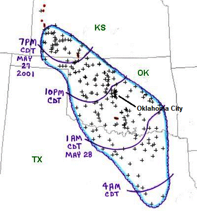
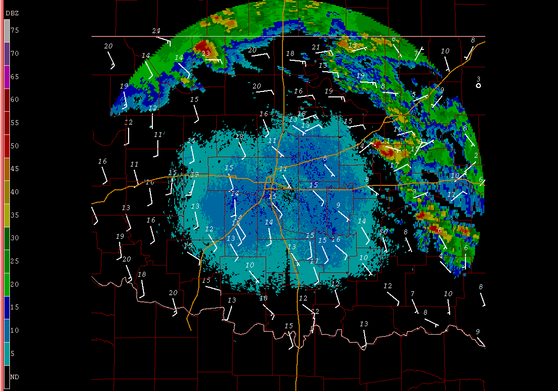
Figure 1. Area affected by the May 27-28, 2001 derecho (outlined in blue). Curved purple lines represent the approximate locations of the gust front at three-hourly intervals. "+" symbols indicate the locations of wind damage or wind gusts (measured or estimated) above severe limits (58 mph or greater). Red dots and lines denote tornadoes.
On Sunday afternoon, May 27th, 2001, isolated supercells, some producing brief tornadoes, formed over western Kansas and far eastern Colorado. As the outflow of cold air from the supercell storms increased, a gust front developed over southwest Kansas and began moving rapidly southeastward. The supercells associated with the gust front eventually evolved into a bow echo squall line, although some supercells continued to be embedded within the line of storms. The southeast-moving bow echo storm system produced a derecho with significant wind damage over a large part of the southern Plains (Figures 1 and 2).
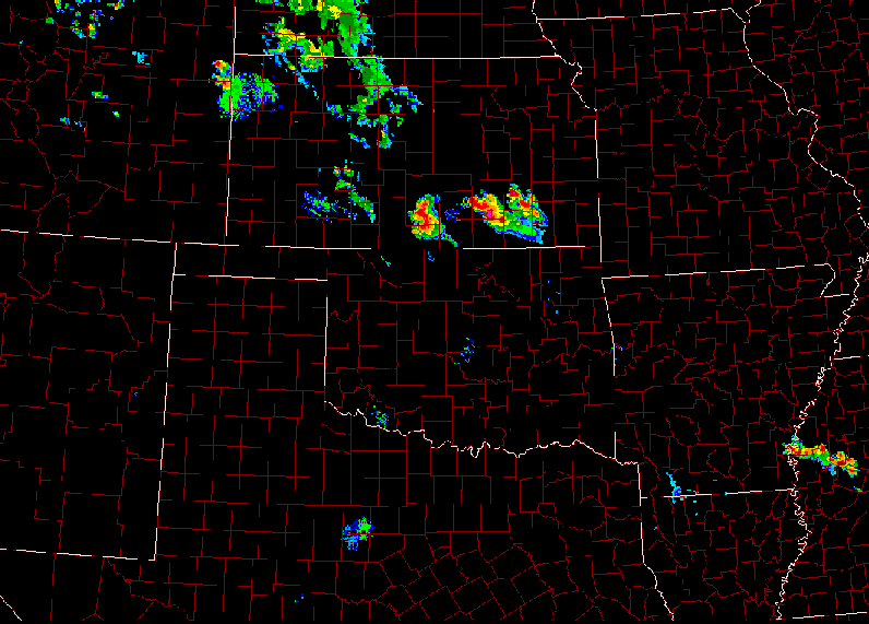
Figure 2. Fifteen-hour composite radar base reflectivity loop showing development and evolution of the May 27-28, 2001 derecho-producing convective system. "Ping-pong" animation begins at 1:22 p.m. CDT (1822 UTC) Sunday, May 27 and ends at 4:10 a.m. CDT (0910 UTC) Monday, May 28.
The maximum wind gust in Kansas reached 100 mph near Garden City, as measured by the Doppler-on-Wheels radar research vehicle. In Oklahoma, a maximum wind gust of 94 mph was measured at Quail Springs Mall in the northwest part of the Oklahoma City metropolitan area; a gust to 93 mph was recorded in Ardmore, Oklahoma. The maximum gust in Texas was 78 mph in suburban Fort Worth. In many areas affected by the system, the severe gusts lasted 10 to 20 minutes before subsiding.
The Oklahoma Mesonet network proved helpful in analyzing the nature of the derecho's severe winds (Figure 3). As the derecho crossed Oklahoma, two bands of stronger maximum wind gusts (70 mph and greater) were recorded in the dense network of Oklahoma Mesonet weather stations. These narrow corridors of enhanced winds (red areas in Figure 3) within the larger-scale swath of severe derecho winds (blue area in Figure 3) were associated with embedded supercells in the line of thunderstorms and bow echoes. The storms assumed a classic line-echo wave pattern (LEWP) or inflection configuration in the Oklahoma City area (Figures 1 and 4).
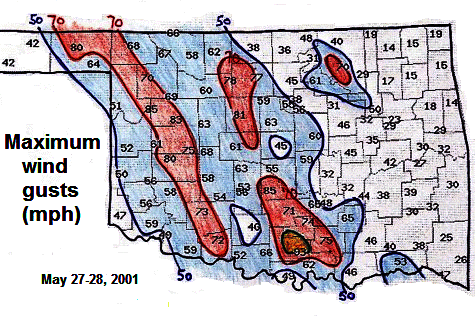
Figure 3. Official maximum wind gusts (in mph) measured by the Oklahoma Mesonet weather stations during passage of the May 27-28, 2001 derecho. Gusts above 50 mph are shaded blue; above 70 mph, red; and above 90 mph, yellow. The isolated area of winds greater than 70 mph in northeast Oklahoma was associated with a cluster of storms separate from the derecho-producing squall line.
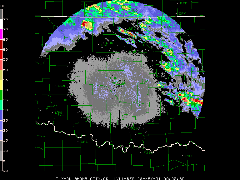
Figure 4. "Ping-pong" animation of Twin Lakes (Oklahoma City) reflectivity imagery for the period from 6:30 p.m. CDT (2330 UTC) May 27 to 1:27 a.m. CDT (0627 UTC) May 28, 2001, showing development of a line-echo wave pattern or LEWP over the Oklahoma City area as the maturing convective system crossed central Oklahoma. Reflectivity intensity scale (dBZ) at left.
Many power poles and lines were blown down as the derecho storm system roared south-southeast across the southern Great Plains. This resulted in many towns and rural areas losing electrical power. In central Oklahoma alone, including the Oklahoma City metropolitan area, 160,000 residents lost electrical power. Many buildings were damaged and roofs were blown off. Several mobile homes were overturned and at least a half dozen semi-trucks were blown over along Oklahoma highways. The worst damage, estimated at over tens of millions of 2001 dollars, occurred in southern Oklahoma in the cities of Lawton, Ardmore, Dougherty, and Hugo.
In
Oklahoma one person was killed by a falling utility pole in Lawton, and four
people were injured at Canton Lake when a mobile home overturned. In north
Texas, a woman was severely injured when hit by a tree limb at a campground
near Lake Texoma.
Animated reflectivity imagery from the Twin Lakes (Oklahoma City), Oklahoma NWS radar showing evolution, observed surface winds (5-minute average, white barbs (mph)), and maximum surface gusts (white numbers (mph)) associated with the May 27-28, 2001 derecho-producing convective system as it crossed central Oklahoma (6:45 p.m. (CDT) May 27 through 12:45 a.m. May 28, 2001). Reflectivity intensity scale (dBZ) at left. Wind observations from the Oklahoma Mesonet.
Animated
visible data satellite imagery showing early evolution of the derecho-producing convective system from thunderstorms that formed over southeast Colorado and
western Kansas (11:30 a.m. through 7:00 p.m. CDT May 27, 2001).
Because Sunday, May 27 was the middle of the Memorial Day weekend, many storm chasers and researchers were able to converge over southwest Kansas that afternoon to observe the expected development of supercells and tornadoes. Supercells did indeed form and a few tornadoes occurred. However, before long, gust fronts produced by the isolated supercells merged and began to race southeast at speeds ranging from 50 to 55 mph. Some of the storm chasers drove south or southeast to stay ahead of the developing derecho gust front, hoping to observe development of new, isolated storms to its south. But the derecho became a "people chaser;" it overtook many of the storm chasers before they could outrun it.
One of the unique features about the May 27-28, 2001 derecho was the large number of photographs of the storm system that were taken, and the detailed radar images that were gathered by a tornado research team. Some of these pictures and radar signatures are shown below; Figure 5 depicts the locations where the data were gathered.
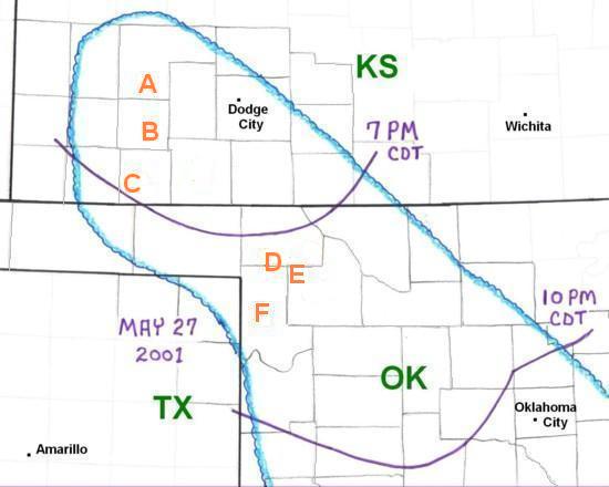
Figure 5. Area affected during the early stages of the May 27-28, 2001 derecho (outlined in blue). Curved purple lines represent the approximate positions of the derecho gust front at 7 PM and 10 PM CDT. The orange letters represent locations where people experienced the derecho and provided information (stories, photographs, etc.) for this web page.
Near the beginning of the event, a scientific team with the "Doppler-on-Wheels" mobile radar unit was able to observe the initiation of the derecho- producing gust front. The team was located in southwest Kansas just to the south of Garden City (orange "A" in Figure 5).
Detailed radar imagery from the Doppler-on-Wheels shows the change in the storm system as it developed into a derecho. Some of this imagery was provided by science team member Curtis Alexander and may seen here.
Because it was relatively dry in this area of the High Plains, the western part of the gust front became a "haboob," with a deep layer of dust and blowing sand. NWS Storm Prediction Center meteorologist Roger Edwards observed this development just southeast of Sublette, KS (orange "B" in Figure 5). As the haboob engulfed him, intense blasts of sand scratched and pitted his car's windshield. He measured a gust of 68 mph using a hand-held measuring device. After the gust front passed, Roger drove south at a speed of 60 mph. As he drove, he held his hand out the window and felt no wind force against his hand --- an extremely unusual experience.
About 20 miles south-southwest of Roger's location, Christopher Godfrey observed the approaching derecho gust front on Kansas State Highway 51 approximately ten miles north-northwest of Liberal, KS (orange "C" in Figre 5). Christopher's photographs (Figures 6 and 7) show the "haboob" characteristics up close, with well-defined wedges of brown dust and sand rushing south with the gust front.
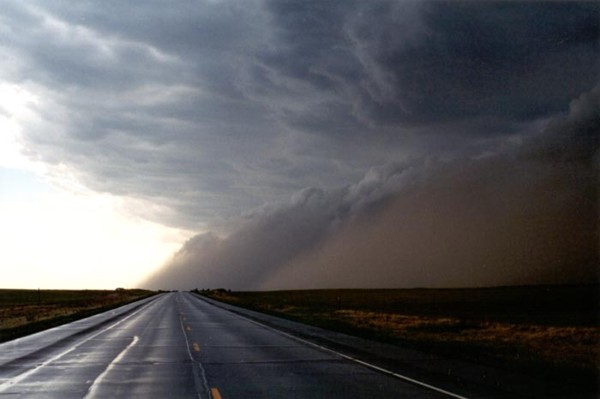
Photograph by Christopher
Godfrey
Figure 6. Looking west along Kansas State Highway 51 from a location about ten miles north-northwest of Liberal, Kansas (orange "C" in Figure 5). Visible are two bulging wedges filled with dust and sand; these were part of the derecho gust front that was racing southward (toward the left).
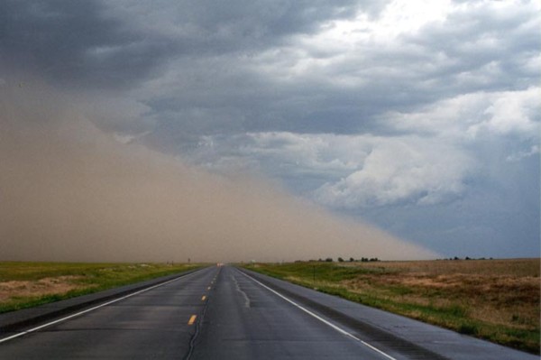
Photograph by Christopher Godfrey
Figure 7. Looking east along Kansas State Highway 51 from the same location as in Figure 6. A part of the gust front filled with dust and sand has crossed the highway, moving rapidly to the south (toward the right).
As the storm system gust front moved southeast into Oklahoma, semi-trailer trucks were overturned in several places. One of the first incidents occurred on Oklahoma State Highway 3 just east of the Oklahoma Panhandle (see Figure 8). Several other trailers were blown over on Interstate 40 west of Oklahoma City as the intense derecho winds moved across the central part of the state.
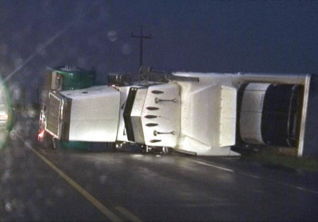
Photograph by Dave Lewison
Figure 8. Semi-trailer truck overturned by derecho winds about 25 miles northwest of Woodward, Oklahoma (orange "D" in Figure 5).
A group of storm chasers from Ball State University drove south from Kansas once the isolated supercells had joined into a linear storm system and widespread outflow winds began to devlop. As they approached Fort Supply, Oklahoma, they looked rearward and saw that a shelf cloud was forming along the leading edge of the storm system. They stopped on Oklahoma State Highway 3 just southeast of Fort Supply (orange "E" in Figure 5).
When Ball State student Douglas Berry got out of his vehicle, he noticed that strong southerly winds were blowing toward the band of storms, suggesting that the the system was ingesting intense inflow. Douglas also noticed that the cloud system was laminar in structure and quite extensive. He had never seen such a large and laminar shelf cloud. Douglas took several photographs of the formation. Some of these pictures have been arranged to provide a panoramic view looking from west-northwest to east-northeast (Figure 9).
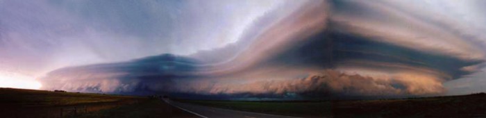
Panoramic view by
Douglas Berry
Figure 9. Panoramic view of the shelf clouds associated with the derecho-producing storm system, seen looking west-northwest to east-northeast from a point near Fort Supply, OK (orange "E" in Figure 5).
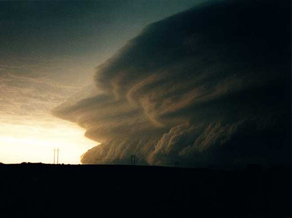
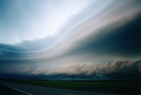
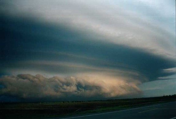
As the storm system moved closer, it loomed much larger and more menacing. Douglas took additional pictures of what he and other Ball State chasers called a "mothership storm" formation (Figs 10, 11, and 12). The National Weather Service radar imagery at this time showed the storm system as a bowing band of storms and suggested that the derecho-producing outflow winds were moving directly toward Douglas's location. (Figure 13). It was around this time that the semi-trailer truck was overturned on State Highway 3, about ten miles west-northwest of Fort Supply (Figure 8).
Photograph by Douglas Berry
Figure 10. View of the derecho-producing storm system as seen looking west to west-northwest from a point near Fort Supply, OK (orange "E" in Figure 5).
Photograph by Douglas Berry
Figure 11. View of the derecho-producing storm system as seen looking north from a point near Fort Supply, OK (orange "E" in Figure 5).
Photograph by Douglas Berry
Figure 12. View of the derecho-producing storm system as seen looking east-northeast to east from a point near Fort Supply, OK (orange "E" in Figure 5).
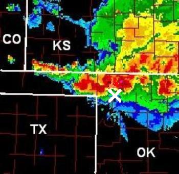
Figure 13. National Weather Service radar view of the derecho-producing storm system as it was about to reach Douglas Berry's location southeast of Fort Supply, OK (white "X").
As the derecho was about to arrive, Douglas and other team members returned to their vehicles. Winds gusted to 70 mph as the derecho moved through, and their vehicles shook. Fortunately, however, the gusts were not strong enough to blow the vehicles over.
Paul Knightley, a meteorologist from England, viewed the derecho as it approached Shattuck, Oklahoma (orange "F" in Figure 5). Paul's time-lapse video of the approaching cloud system is available here.
_____________________________________________________________________________
Additional information:
Miller et al. 2002
Storm Data, May 2001
Back to Noteworthy Derechos list