MAY 17, 1986 DERECHO
"The Texas Boaters' Derecho"
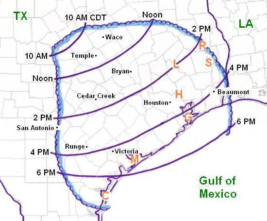
Figure
1. Areas of
central and southern Texas affected by the May 17, 1986 derecho (outlined
in blue). Curved purple lines represent the approximate locations of the squall
line (based on surface observations) at two hourly intervals (in CDT).
The orange capital letters represent the locations of water bodies where hundreds
of boats were capsized or swept onshore by strong downburst winds during
the derecho. These include Lakes Sam Rayburn ("R"), Livingston
("L"), Steinhagen ("S"), Houston ("H"),
Galveston Bay ("G"), Matagorda Bay ("M"), and Corpus Christi
Bay ("C").
Saturday, May 17, 1986, was a big day for pleasure boaters over parts of eastern and southern Texas. Both a fishing tournament and a racing contest were bringing hundreds of boaters to Lake Livingston (orange "L" in Figure 1). Many sail boaters were entering portions of Galveston Bay (orange "G" in Figure 1) for scheduled regattas. And, hundreds of individual boaters were taking advantage of the warm weekend to go fishing in their boats or to enjoy other forms of pleasure boating on lakes and coastal waters in the region.
Unknown to most of the boaters, during mid-morning a line of thunderstorms formed over central Texas (TX) near a southward-moving cold front. Around midday this line of storms started to produce damaging winds as it moved southeast toward Waco and Temple (see Figure 1). During the following afternoon, the squall line accelerated rapidly southeastward, producing a derecho that affected much of southeast texas.
Significant wind damage affected several communities and cities. In Temple, several trees and power lines were blown down, several homes were damaged, and a truck was blown over. Three people were injured when a tent was blown down at a golf tournament in Bryan. Homes were damaged and barns were destroyed near Cedar Creek in Bastrop County. Part of a school roof was blown off in Runge. A motel roof was blown off and homes were damaged in and near Beaumont, and planes were damaged at the Beaumont airport. At the National Weather Service Office in Victoria, a gust of 68 mph was measured as the storm front moved through. Two hangers were damaged and a plane was blown over at a nearby airport.
Although
there was significant damage in several communities and cities associated
with this derecho, it would prove to be far more frightening and even deadly for
weekend boaters in southeast Texas. What began as a decent day for pleasure boating
quickly changed, as the sky darkened to the northwest and the storm gust front
rapidly overtook many boaters before they could reach the shore. The water bodies hit
by the strongest downburst winds are shown on Figure 1 and include Lake Sam Rayburn,
Lake Livingston, Lake Steinhagen, Lake Houston, Galveston Bay, Matagorda Bay, and
Corpus Christi Bay. Hundreds of boats were capsized by the severe storm winds, and
many of their occupants became stranded in the water. Six boaters
drowned and others were injured. Many of the stranded had to be rescued.
The U. S. Coast Guard reported that in Galveston Bay alone, 140 people had
to be rescued in association with 65 boats. About 60 of these people had to
be pulled out of the water. Others stranded in Galveston Bay were rescued by
individual and private company boaters. One of these people, clinging to his
overturned fishing vessel, was not rescued until the following day.
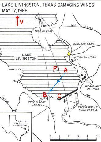
Figure
2. Map showing where downburst winds (long thin black arrows) affected the
southern portion of Lake Livingston, Texas (orange "L" in Figure 1).
Areas where buildings were damaged and trees were damaged or blown down
also are shown. The red capital letters and the blue-arrowed line (described
in the text below) show where specific boaters were affected. (Modified from
Storm Data, May 1986)
Lake Livingston, where five people drowned, was the scene of the greatest tragedy with this derecho. One person drowned as he tried to rescue his son near Point Venture (on the north part of the lake as indicated by the red arrow and "V" in Figure 2). Four other boaters perished near the west side of the dam (red "C" on Figure 2). Even though they wore life jackets, they still were not able to survive. One person was found floating on the water near the dam; the other three were found trapped on the bottom of the lake below their boat. The 21 foot-long cruiser had been broken into several pieces. It appears that the boaters and their boat were driven into the rocks of the dam wall by the big waves, and were too severely injured to escape from the water. Scores of other people, many of whom were involved in the fishing tournament and the boat races, had narrow escapes as their vessels capsized, or were battered or blown over upon reaching the boat docks. Many had to swim to shore, and several who made it to Pine Island (red "P" on Figure 2) remained stranded there until being rescued the next day. There also was considerable damage to trees and buildings near the lake shore (Figure 2). Figure 3 shows a barn that was severely damaged on the eastern side of the lake.
Storm Prediction Center meteorologist Richard (Rich) Thompson experienced this event during a summer break from the University of Oklahoma. Rich, a native of Houston, had gone on a weekend camping and boating trip with several friends. On Saturday, May 17th, they arrived at Lake Livingston, placed their 16 foot-long boat in the water and began water skiing in the southeast part of the lake between Pine Island and the southeast shore (red "A" on Figure 2). Rich realized that there was a risk of thunderstorms that day. Since there was a radio on the boat, Rich checked local radio broadcasts on several occasions to see if there was any news about storm development in the region. However, he heard nothing.
During the afternoon, Rich noticed that the sky was gradually graying to the west and northwest, suggesting that a thunderstorm was slowly approaching the lake but was still some distance away. Even though this visual clue was nothing spectacular, Rich was a bit concerned because of the risk of being struck by lightning when the thunderstorm would finally arrive at the lake. So, after discussing the potential risk with his friends, they began to move back toward the marina at a comfortable pace. The route to the marina was about 4 miles long (blue line with arrows on Figure 2).
About 10 or 15 minutes after they began returning to the marina, Rich realized that the storm was approaching faster than he originally thought, and he became seriously concerned about reaching the marina (red "B" on Figure 2) before the storm overtook them. So they put the boat on full-throttle and began racing toward the marina. When they were still about 5 to 10 minutes away from the marina, Rich saw the dark murk of the west and northwest sky give way to a well- defined storm gust front with a deep blue-green hue. Rich then realized that the storm was approaching very rapidly, and that strong, damaging winds would be a real threat. Would they be able to make it back the marina boat docks before the storm gust front hit? A few minutes later the gust front appeared as a blue-green "bulldozer blade," with the appearance of several teeth below a flat shelf cloud. Below the shelf cloud was a detached, horizontally-rotating "roll cloud" just a few hundred feet above the surface; this feature was moving rapidly toward them. The boat was still about a mile from the docks. By this time the gust front already had hit the north end of Lake Livingston and, unknown to Rich and his friends, boats there had capsized and one person had drowned near Point Venture.
By the time they were about 200 yards from the boat ramp, Rich and his friends could see a "spray foot" moving towards them on the lake as the wind shift line and gust front moved across the water surface. Then, a few seconds later, the water spray and gust front hit them and the surface winds shifted from southeast to northwest and quickly increased to about 40 mph or greater. Fortunately, this reversal of the wind direction briefly tended to flatten the waves, and Rich and his friends made it back to the docks safely. Many other boats were converging and arriving at the docks at the same time.
While
Rich was relieved to have gotten back to the boat docks, the threat from the
strong winds was not over. During the next ten minutes the winds would keep
increasing in speed, finally exceeding "hurricane force" (greater
than 75 mph). Once all six people were out of the boat, they tried pulling
the boat out of the water. However, they were unable to get the boat out
as the waves were increasing in height and began crashing the boat into the
concrete dock, severely damaging its hull. They were knocked back from
the boat themselves as the 8 foot-high wave crests broke over their heads.
The badly damaged boat finally sank. As they were trying to save the boat,
Rich looked up and saw the top 20 feet of a tall cedar tree break and fly
off to the south. About this same time, not far to the southeast of Rich,
four other boaters were drowning near the dam since they were not able to
make it back to boat docks in time. Finally, after twenty minutes of chaos,
the winds and waves died down. Rich would later hear about the deaths
and injuries that occurred on Lake Livingston that day, and felt
fortunate to have made it back to shore before the height of the storm.
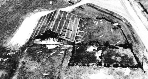
Figure
3. Badly damaged barn on the east side of Lake Livingston (located at the
black "dot" outlined in yellow in Figure 2). (From Storm Data, May 1986)
In
summary, the May 17, 1986 derecho began around midday in central Texas
and moved rapidly southeast, crossing the Gulf of Mexico coast during
the late afternoon and early evening. Although there was some significant
wind damage on land, this windstorm primary affected weekend pleasure
boaters on lakes and other water bodies in southeast Texas. Hundreds of
boats were capsized or blown ashore, and many were damaged or destroyed. Five
people drowned on Lake Livingston and another person drowned on Lake Steinhagen.
An unknown number of others were injured. Over one hundred boaters had to
be rescued, particularly on Galveston Bay, and a few people were not rescued
until the next day. This derecho well illustrates the dangers posed by
severe downburst winds to pleasure boaters.
_____________________________________________________________________________
Additional information:
The Houston Chronicle, archived newspaper articles from May 18-20th, 1986
Storm Data, May 1986
Back to Noteworthy Derechos list