MARCH 12-13,
1993 DERECHO
"The
'Storm of the Century' or 'Superstorm' Derecho"
Affected Florida, southeast Georgia, Cuba, and adjacent waters
On Friday, March 12, 1993, a strong low pressure system formed in the Gulf of Mexico. This low pressure system continued to strengthen dramatically and moved northeast to the mid-Atlantic coastal region by Saturday evening, March 13th. Besides producing a record snowstorm over the eastern United States, this low pressure system was accompanied by an intense squall line with embedded bow echoes ahead of the system's cold front (Figures 1 and 2). The squall line produced a serial derecho as it swept across the Florida peninsula, Cuba, and adjacent waters. The squall line reached the northern part of Florida's west coast and western Cuba between 11 p.m. and midnight (EST) on the evening of the 12th. After causing much damage and producing many casualties, the storm line moved off the southeastern coast of Florida around 5 a.m. on the 13th, and departed central Cuba after sunrise.
As shown in Figure 1, much wind damage occurred across Florida, with measured wind gusts reaching a maximum of 96 mph in the Tampa Bay area. Supercells and small-scale bowing segments within the squall line (Figure 3) produced tornadoes and/or tornado-like damage over the northern half of the Florida peninsula, with some of the damage reaching F2 intensity.
Seven people were killed and 79 were injured from storm winds and embedded tornadoes as the derecho-producing squall line raced through the state. Storm winds blew down countless trees, power poles, and power lines, and tore roofs off homes. Mobile homes were severely damaged, and trucks were overturned.
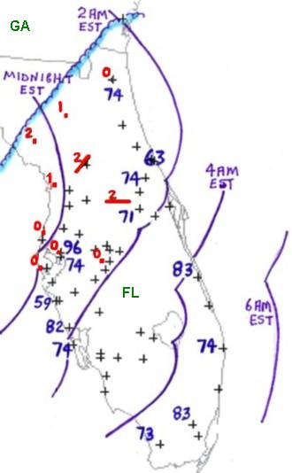
Figure 1. Severe weather reports in Georgia and Florida (south of blue shaded line) associated with the derecho of March 12-13, 1993. Measured gusts in mph are plotted (blue numbers); "+" symbols indicate the locations of wind damage or estimated wind gusts above severe limits (58 mph or greater). Red dots and paths indicate tornado events. Small red numbers indicate tornado intensities in F-scale. The approximate location of the squall line "gust front" is shown in two-hour increments (curved purple lines).
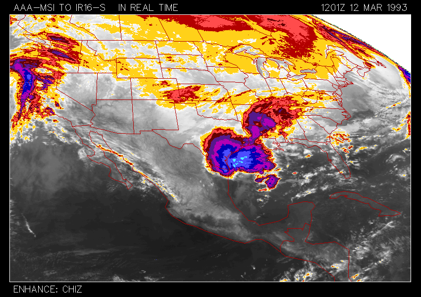
Figure 2. Thirty-eight-hour infrared data satellite loop showing development and progress of the derecho-producing squall line associated with the "Storm of the Century" that affected the eastern third of the United States on March 12-13, 1993. "Ping-pong" animation begins at 7:00 a.m. EST (1200 UTC) Friday, March 12 and ends at 9:00 p.m. EST Saturday, March 13 (0200 UTC March 14). Color enhancement scale not shown, but cloud tops colder than -55 °C appear dark blue (approximately 14 km or 46,000 ft), and those colder than -60 °C, light blue (approximately 15 km or 50,000 ft). The squall line forms over the north central Gulf of Mexico early in the loop and subsequently develops southward across the Yucatan peninsula and western Caribbean Sea, comprising the southern end of the prominent "comma cloud" associated with the parent low pressure system. The intense low was centered over southern Delaware at 9.00 p.m. March 13 and was responsible for an expansive area of heavy snow and/or high winds over tbe eastern United States. At its greatest extent, the squall line reached from Central America to off the coast of Georgia.
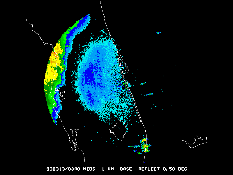
Figure 3. Seven-hour animation of base reflectivity data from the Melbourne, Florida NWS radar, showing progress of the derecho-producing squall line over central Florida on March 12-13, 1993. "Ping-pong" animation begins at 10:40 p.m. EST March 12 (0340 UTC March 13), and ends at 5:40 a.m. (1040 UTC) March 13. Color enhancement scale not shown. Toward the end of the sequence, two well-defined small-scale bowing segments appear over the Atlantic coastal waters within the larger-scale bow. Both were associated with embedded supercells. In the wake of the intense squall line, a band of much weaker convection marks the cold front trailing southwest from the parent storm system along the mid-Atlantic coast.
While the derecho was moving through Florida, it also was affecting Cuba. The event caused ten deaths and many injuries in western and central Cuba. Economic losses in Cuba exceeded one billion U.S. dollars. The squall line crossed Cuba and the adjacent coastal waters during the morning of March 13th with two bands of very intense wind gusts (Figure 4). These were associated with smaller-scale bow echoes embedded in the squall line. The western band extended from the western tip of Cuba along the north coast to beyond Havana, while the eastern one reached from east of the Isle of Pines across central Cuba. Gusts to more than 100 mph were measured in the Havana area, and a survey conducted by a research team from the Institute of Meteorology of Cuba suggests that the maximum wind speeds may have reached 130 mph. Figure 5 provides a radar view of the bow echo associated with the western band of intense winds as it approached Havana.
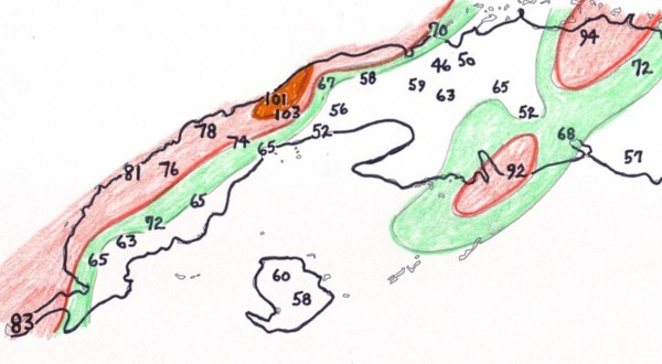
Figure 4. Measured wind gusts (mph) associated with the March 12-13, 1993 serial derecho as it crossed western and central Cuba. The colored areas on the map indicate where wind gusts ranged from 65 to 75 mph (green), 75-100 mph (light red) and 100 mph or greater (dark red). (Modified from Alfonso and Naranjo 1996)
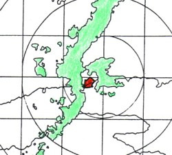
Figure 5. Radar reflectivity image (green) of the derecho-producing squall line and associated bow echo as seen by the Havana radar at 2:59 a.m. EST March 13, 1993. The bow echo was approaching Havana, and winds above 100 mph were occurring. The red arrow is pointed toward an apparent embedded supercell that may have enhanced the strength of the bow echo winds. (From Alfonso and Naranjo 1996)
_____________________________________________________________________________
Additional information:
Alfonso and Naranjo 1996
Storm Data, March 1993
Back to Noteworthy Derechos list