JUNE 29, 1998
DERECHO
"The Corn Belt Derecho of June 1998"
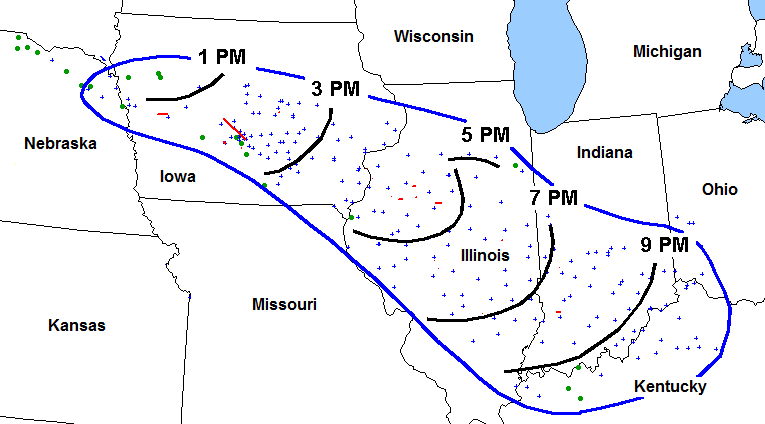
Figure 1. Area affected by the June 29, 1998 derecho (outlined in blue). Approximate two-hourly positions (CDT) of the derecho gust front indicated by curved black lines. Blue "+" symbols indicate locations of wind damage or wind gusts (measured or estimated) above severe limits (58 mph or greater). Severe hail denoted by green circles; tornadoes by red dots or lines.
A small area of thunderstorms formed on a warm front over extreme southern South Dakota around 9:00 a.m. CDT on the morning of Monday, June 29, 1998. The storms quickly grew in size and strength as they moved / developed east-southeast into northeast Nebraska, producing hail up to the size of hen's eggs and locally damaging wind (Figure 1). By midday, the storms had expanded east into northwestern and north central Iowa, and organized into an west-east band. Around this time, embedded supercells in the line assumed bow echo configurations and began to produce very strong winds, in addition to tennis ball-sized hail and several mostly short-lived tornadoes.
The Des Moines area was particularly hard-hit. Although the evidence remains somewhat inconclusive, it appears that the large, fast-moving mesocyclone of one supercell was nearly in contact with the ground as it moved from southwest Boone County east-southeast across the northern and eastern parts of the Des Moines metro area. This feature appears to have been responsible for the most intense damage along this corridor. The damage path began fairly narrow but widened to nearly seven miles near Granger in eastern Dallas County, where a duplex apartment home was destroyed. In Des Moines, Polk County, roofs were lifted off stores and homes, planes were flipped at an air field just north of the city, and heavy construction equipment and semi-trailer trucks were overturned on Interstate 35-80. Up to 100,000 homes lost power, and power to some parts of Des Moines was not restored for nearly a week. The damage, totalling an estimated $100 million in Polk County alone, was consistent with wind speeds of 110-155 mph (F2 strength).
A second area of storms that had formed west of Des Moines during the early afternoon merged with the lead bow as it moved beyond Des Moines around 2:00 p.m. CDT. The merging storms evolved into a larger scale bow echo storm system that subsequently accelerated east-southeast across southeast Iowa and into Illinois by 4:00 p.m. (Figure 2). In addition to flattening many miles of corn crops (in some areas up to 75% of the crop was estimated to have been destroyed), the derecho toppled countless trees and power lines, and produced an unofficial measured wind gust of 126 mph in the town of Washington, south of Iowa City. Severe gusts in Iowa City lasted more than 20 minutes. Statewide, 80 homes were destroyed and more than 1400 were damaged by the storm. Although the storm produced no fatalities in Iowa (or elsewhere), many in the state were injured by flying debris.
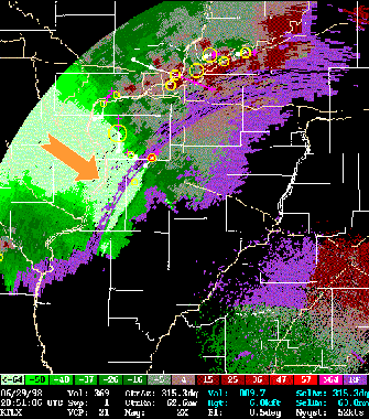
Figure 2. Radar velocity display showing band of derecho winds sweeping east-southeast across southeastern Iowa into far western Illinois at 3:51 p.m. CDT, June 29, 1998. The area of light green (beneath orange arrow) represents Doppler-estimated wind speeds in excess of 64 kts. White lines denote state and county borders. (Data from the Lincoln, Illinois NWS radar courtesy of James Auten, NWS Lincoln)
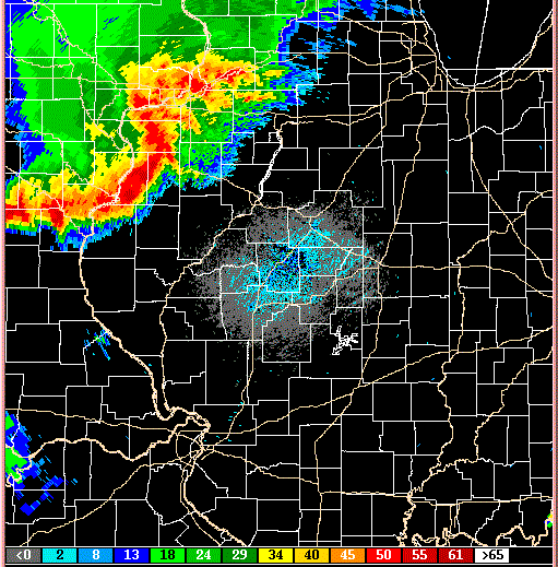
Figure 3. Radar reflectivity loop showing evolution of derecho-producing convective system over central Illinois between 3:51 p.m. and 6:58 p.m. CDT, June 29, 1998. Echo intensity scale (dBZ) at bottom. White lines denote state and county borders. (Data from the Lincoln, Illinois NWS radar courtesy of James Auten, NWS Lincoln)
The convective system evolved into a classic large scale bow echo, complete with a "book end vortex" on its northern end, as it continued southeast across central Illinois through early evening (see animated radar reflectivity from the Lincoln, Illinois NWS radar site in Figure 3). Damage, especially to crops and trees, was continuous in a broad swath from the Iowa border into Indiana. Most of the damage was produced by strong straight-line winds on the leading edge of the gust front. But embedded supercells, mesocyclones and smaller-scale vortices produced narrower corridors of more intense damage, with measured wind gusts up to 110 mph. These winds toppled railroad cars, bent steel power transmission towers, and seriously damaged many buildings. Total damage in Illinois was estimated at $16 million, with a dozen people injured.
The derecho swept across central and southern Indiana during the early to mid evening. Although the highest wind gusts decreased somewhat compared with those observed earlier in the day, 40 to 70 mph winds caused damage in nearly every county in the region. Hundreds of trees were uprooted in the Bedford (south of Bloomington) and Indianapolis areas, and two semi-trailer trucks were blown off Interstate 65 near Columbus.
The system expanded along a roughly west-east arc and turned more southward as it moved into Kentucky during the late evening. Damage in that state primarily was limited to trees, although several roofs also were blown off.
In summary, the "Corn Belt Derecho of 1998" traveled more than 600 miles in about ten hours, causing more than $125 million worth of damage. It produced widespread destruction, especially to crops, and was responsible for electrical outages that affected nearly a half million people. The event also was noteworthy as it spurred investigation into the origin and behavior of the small-scale vortices that were observed in this and similar derecho- producing convective systems. The Atkins et al. 2004 paper available here summarizes these findings. A brief technical overview of the early stages of the June 29, 1998 storm system prepared by the NWS's St. Louis Forecast Office is available here. Additional radar views, including detailed displays of the large scale bow echo that moved through eastern Iowa and western Illinois, are available on this page produced by the National Weather Service office in Quad Cities, Iowa--Illinois.
_____________________________________________________________________________
[Radar data for this event provided by J. Auten of the Lincoln, Illinois National Weather Service office, who also suggested that the 29 June 1998 derecho be included in "About Derechos."]
Additional information:
Storm Data, June 1998
Back to Noteworthy Derechos list