JULY 4, 1977 DERECHO
"The Independence Day Derecho of 1977"
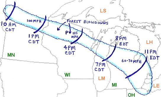
Figure 1. Area affected by the July 4, 1977 derecho event (outlined in blue). Curved blue lines represent the approximate locations of the gust front at three hourly intervals. "P" represents the location of Phillips, Wisconsin.
The"Independence Day Derecho of 1977" formed over west central Minnesota (MN) on the morning of Monday, July 4th (Figure 1). As the derecho moved east-southeast, it became very intense over central Minnesota around midday. From that time through the afternoon the system produced winds of 80 to more than 100 mph, with areas of extreme damage from central Minnesota into northern Wisconsin (WI). The derecho continued rapidly southeast across parts of Lower Michigan (MI) during the evening, producing winds up to 70 mph and considerable damage before finally weakening over northern Ohio (OH) around 1:30 a.m. EDT on Tuesday, July 5th.
After this storm occurred, Dr. T. Theodore Fujita, a meteorology professor at the University of Chicago, became aware of the extreme wind damage in northern Wisconsin and decided to conduct a scientific investigation of the event. By observing the damage pattern from the air, he found that there were three areas where extreme damage and forest blowdowns took place. One extended from central Minnesota into extreme northwest Wisconsin (shaded area "A" on Figure 2b), and the other two extended across a long corridor of northern Wisconsin (shaded areas "B" and "C" on Figure 2b).
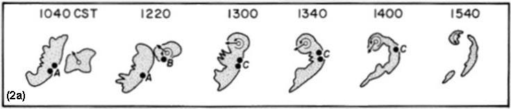
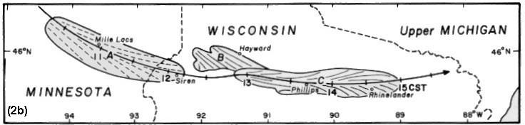
Figure 2. (a) Evolution of radar reflectivity showing bow echo system of July 4, 1977. Numbers above echoes are time, CST. (b) Areas of most intense downburst damage, including forest blowdowns (shaded areas) that occurred on July 4, 1977, as determined by an aerial survey by Dr. T. T. Fujita. Orientation of fallen trees indicated by dashed and solid lines in the shaded areas. Heavy solid line depicts path of central part of the bow echo system, with tick marks indicating one-half hour time increments in CST. (From Fujita 1978).
Fujita also examined the radar echoes associated with the damage path across eastern Minnesota and northern Wisconsin. He noticed that the echoes evolved into a bowed out signature (Figure 2a). It was from the study of this derecho that Fujita coined the term "bow echo" that is widely used today.
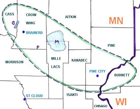
Figure 3. Approximate area affected by severe downburst damage in Minnesota and extreme northwest Wisconsin during the derecho of July 4, 1977 (Area enclosed in green line and corresponding to shaded area "A" in Figure 2b).
The counties affected by the first series of intense downbursts associated with the July 4, 1977 derecho, mostly in Minnesota, are shown on Figure 3. Estimated wind gust from 80 to 100 mph roared through this area between noon and 2 p.m. CDT causing hundreds of thousands of dollars worth of damage to personal property. Thousands of trees were blown down, extensively damaging cabins and cars. Shortly after the intense winds began, the roof was blown off the Gull Lake Lodge ("G" on Figure 3) near the Cass/Crow Wing County line. As the derecho winds reached Platte Lake ("P" on Figure 3), a woman sustained a broken leg when her mobile home was overturned. Some of the worst damage occurred at Milles Lacs Lake ("M" on Figure 3) where a resort lodge and several boats were totally destroyed. One launch caught on the lake during by the derecho winds had to ride out eight to ten foot waves for almost an hour. Farther downstream, the storm system's winds stripped and flattened large areas of crops in Kanabec and Pine Counties, and downed trees in the forested areas of Burnett County Wisconsin.
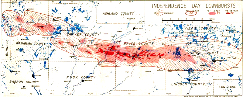
Figure 4. Area affected by severe downburst damage over northern Wisconsin during the derecho of July 4, 1977 (shaded areas "B" and "C" on Figure 2b). From the damage severity, wind gusts were estimated to have been between 73 and 112 miles per hour in the light red shaded areas, and from 113 to 157 mph in the dark red shaded areas. (From Fujita 1978).
As the derecho continued across northern Wisconsin during the afternoon of Independence Day 1977, a series of intense downburst winds caused major forest blowdowns, widespread severe damage to property, and many casualties. This band of extreme damage, which was 10 to 20 miles wide and over 160 miles long, extended from eastern Burnett County through Washburn, Sawyer, Price, and Oneida Counties (Figure 4). Approximately 850,000 acres of trees were either destroyed or badly damaged, and damage estimates including buildings and vehicles totaled about $24 million dollars. One person was killed and 35 were injured.
As the bow echo system moved into Sawyer County, a gust of 75 mph was recorded at 1:40 p.m. CDT at the Hayward Airport near the north edge of the storm complex. Continuing across the county, the downburst winds destroyed many barns and cabins and injured eight people. In the southeastern part of the county, derecho winds wreaked havoc in the Flambeau River State Forest where winds were estimated to have reached 135 mph. In the forest, one person was killed at Conner Lake when a tree fell on her camper van. Nearby, the "Big Block," one of the only areas of virgin forest in Wisconsin, was completely destroyed.
The derecho then crossed Price County, damaging or destroying many homes and injuring 20 people. The gust front reached the county seat of Phillips at 2:55 p.m. CDT, where severe winds lasted 25 minutes. The anemometer at the Phillips Airport registered a speed of 100 mph before being blown away. All homes in the Phillips area were damaged, with thirty beyond repair.
After leaving Price County, the bow echo system entered Oneida County and continued to severely damage homes and blow down large areas of forest. Seven people were injured across the county. The gust front entered Rhinelander about 3:30 p.m. CDT, and a gust to 115 mph was recorded at the Rhinelander Airport. After crossing Oneida county the severe winds continued through northeast Wisconsin to Lake Michigan (LM) . However, the strength of the winds and the extent of the damage were not as great as they had been farther west.
After crossing Lake Michigan, the bow echo system entered Lower Michigan near the towns of Manistee and Ludington just before 8 p.m. EDT (Figure 1). The gust front with winds of 60 to 70 mph moved southeast across the state during the evening, blowing over many trees that damaged homes, utility lines, and vehicles. One woman was injured when a tree fell on her car. In addition to the damaging straight-line winds, the bow echo system had tornadoes associated with it from central Lower Michigan into the southeast part of the state. Two people were injured by these tornadoes, one from an overturned mobile home and the other from an overturned camper. As the bow echo system entered northern Ohio during the early morning hours of Tuesday, July 5th, some outbuildings and trees were damaged but the thunderstorm system and the derecho ended shortly thereafter.
In summary, the Independence Day Derecho of 1977 traveled 800 miles in 14 hours from the Upper Mississippi Valley region to the Lower Great Lakes. One person was killed and 37 were injured. Approximately 1,000,000 acres of forest were badly damaged or destroyed, and total damage estimates exceeded $30 million in 1977 dollars. It was this derecho that caught Fujita's interest in bow echoe storms, and from his research on this case the term "bow echo" was defined.
Additional information on the July 4, 1977 derecho, including aerial photographs of the damage in northern Wisconsin, may be found here, on the NWS Green Bay, Wisconsin Forecast Office's web page.
_____________________________________________________________________________
Additional information:
Fujita 1978
Storm Data, July 1977
Back to Noteworthy Derechos list