JULY 28-29
1986 DERECHO
"The Supercell Transition Derecho"
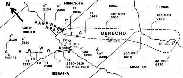
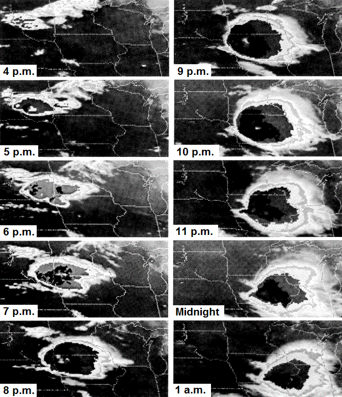
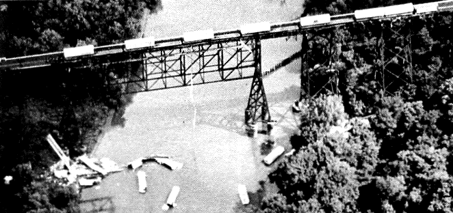
Figure 1. Severe weather outbreak of July 28-29, 1986. Tornadoes are indicated by "T" or as linear paths, with intensities noted in "F" scale (F0=weak, F4=violent). Large hail is indicated by "A," with hail diameter in inches. Damaging winds are denoted by "W." The widespread severe winds of the derecho are included within the dashed line. Times are in Universal Time (UTC); these are converted to CDT in the description below (CDT = UTC - 5). Note that map is rotated such that top is toward the northeast, rather than north. (From Johns and Leftwich 1988) On Monday afternoon, July 28, 1986, isolated supercells formed over parts of South Dakota and began to produce large hail, damaging winds, and tornadoes (Figure 2). The first severe reports occurred at 4:30 p.m. CDT (2130 UTC). The supercell that moved south-southeast through southwestern Minnesota evolved into a bow echo as it reached northwestern Iowa (see Figures 2, 3, and 4). This bow echo grew in scale and produced a derecho as it accelerated southeastward. Gusts greater than 80 mph occurred in the Des Moines area about 10:15 p.m. CDT (0315 UTC), and 100 mph winds caused considerable damage as the storm raced through northeast Missouri and western Illinois. The derecho finally diminished over the St. Louis area around 3:30 a.m. CDT (0830 UTC) the following morning. The evolution of the associated convective system as viewed by satellite is given in Figure 5, and an example of the damage produced by the derecho is shown in Figure 6. |
|||||
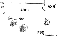
Figure 2. Radar reflectivity at 4:52 p.m. CDT, showing isolated supercells over central and eastern South Dakota. (ABR = Aberdeen, South Dakota, AXN = Alexandria, Minnesota, and FSD = Sioux Falls, South Dakota). |
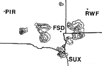
Figure 3. At 6:42 p.m. CDT, the supercell over southwestern Minnesota is evolving into a bow echo. (PIR = Pierre, South Dakota, RWF = Red Wood Falls, Minnesota, and SUX = Sioux City, Iowa). |
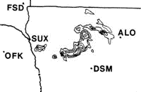
Figure 4. By 9:40 p.m. CDT, the bow echo had become well-defined and was producing a derecho over northwest Iowa. (ALO = Waterloo, Iowa, DSM = Des Moines, Iowa, and OFK = Norfolk, Nebraska). |
|||
Figure 5. Infrared satellite evolution of the July 28-29, 1986 derecho-producing convective system. Times are CDT. Nearly circular, very high (cold) cloud canopy apparent in the 9 and 10 p.m. images is characteristic of well-organized derecho-producing convective systems. (Photos by NOAA-NESDIS; appeared in Storm Data, July 1986) |
|||||
Figure 6. As the derecho passed near Boone, Iowa, it caused the derailment of 18 piggyback trailer cars of a westbound freight train crossing the Kate Shelley bridge. Sixteen of the cars fell 187 feet into the Des Moines River. (Photo taken July 29, 1986 by W. Taylor, The Des Moines Register; appeared in Storm Data, July 1986) |
|||||