THE MID-JULY 1995 DERECHOS:
Series Overview

Figure 1. Outline of areas affected by four derechos during the period of July 11 through July 15th, 1995. The general area of an intense heat wave is shown over parts of the Midwest, including the southern Great Lakes. The derechos are described below.
An exceedingly warm and humid air mass produced a deadly heat wave over parts of the Midwest during mid-July 1995. The broad area of hot and humid air contributed to the development of a series of progressive derechos along a nearly stationary west-east front along the northern fringe of the heat wave region (Figure 1). Four derechos occurred over portions of the northern United States and southern Canada between the evening of July 11th and the morning of July 15th, and the storm paths are shown as colored outlines in Figure 1.
1. The first derecho (outlined in green) began in eastern Montana (MT) during the early evening of July 11th and ended over northern Wisconsin (WI) and Upper Michigan (MI) by mid-morning on July 12th.
2. The second derecho (outlined in orange) began the next evening, July 12th, over eastern Montana (MT) and followed nearly the same track as the one the night before, reaching northern Wisconsin (WI) and Upper Michigan (MI) by mid-morning on July 13th. However, unlike the previous day's derecho, this one continued through the remainder of the day and well into the evening, turning south across eastern Lower Michigan (MI) and a part of southern Ontario (ON), reaching southern Ohio (OH) around midnight.
3. The third derecho (outlined in purple) began over western South Dakota (SD) during the late evening of July 13th as the second derecho was nearing its demise in Ohio (OH). This derecho moved northeast, reaching northeastern Minnesota (MN) before dissipating around dawn on July 14th. For some residents of northern Minnesota, this would be the third consecutive night that a derecho moved through the area causing serious damage.
4. The fourth derecho (outlined in red) began in eastern Upper Michigan (MI) on the evening of July 14th. This derecho crossed southern Ontario (ON) and western and northern New York (NY) during the night and moved off the coast of southern New England by mid-morning on July 15th.
The second (orange) and fourth (red) derechos were the most significant events of the series, and they are described in more detail below.
JULY
12-13, 1995 DERECHO
"The Right Turn Derecho"
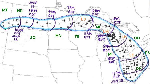
Figure 2. Area affected by July 12-13, 1995 derecho (outlined in blue). Curved purple lines represent approximate locations of the gust front at three hourly intervals. "+" and "w" symbols indicate the locations of wind damage or wind gusts above severe limits (measured or estimated at 58 mph or greater).
During the late afternoon of Wednesday, July 12, 1995, thunderstorms formed over southeast Montana (MT) and began producing winds that damaged homes and barns and blew over a mobile home. As the storm system moved east across North Dakota (ND), vehicles were overturned and a grain bin was destroyed. Measured winds reached 70 mph at Bismarck. As the system approached Fargo during the early morning of July 13th, it became a well-defined bow echo storm with measured winds of 91 mph at the Fargo airport. The derecho was becoming a "high end" event.
The derecho took a track similar to one of the previous night (outlined in green in Figure 1), producing significant damage for the second night in a row from southeast North Dakota eastward across Minnesota (MN) to western Lake Superior (LS) (Figure 2). Damage was extreme across Minnesota, with over five million trees blown down and many buildings damaged and some destroyed. Six campers were injured from the falling trees during the pre-dawn hours. Trucks with plows were needed to clear many of the roads, and some areas were without power for a week. Damage totaled well over $30 million in 1995 dollars.
As the derecho continued east across extreme northern Wisconsin (WI) and Upper Michigan (MI) on the morning of July 13th, many more thousands of trees were blown down and another camper was injured by a falling tree. By early afternoon the derecho entered Lower Michigan (MI) and turned south-southeast (Figure 2). Millions of dollars worth of damage, three deaths, and several injuries occurred in northern and eastern parts of Lower Michigan during the afternoon and early evening of July 13th. In Roscommon County alone, 100,000 trees and 100 miles of power lines were blown down. In southeastern Lower Michigan over 400,000 of Detroit Edison's customers lost power. This was the largest power outage for Detroit Edison since the July 7, 1991 derecho.
While the derecho crossed Lower Michigan, it also also created havoc over parts of southern Ontario (ON). In the town of Goderich on the eastern side of Lake Huron (LH) (green shaded circle in Figure 2), hundreds of trees were blown down, some more than 100 years old. There also was damage to many buildings and vehicles, and a state of emergency was declared. Farther south in Ontario, winds reached 120 km/hr (75 mph) at London and Parkhill (indicated by "w" in Figure 2.)
Many boaters were on Lake Erie (LE) as the storm approached rapidly from the north. On the United States side of the lake, most were caught by surprise as the derecho winds moved well ahead of the bow echo storm. Dozens of boats were capsized or destroyed on rocks. One boater was badly injured when his boat was overturned near Lorain, Ohio, and he later died. Nine other boaters suffered injuries. The U.S. Coast Guard received 152 calls for assistance and had to rescue many people. One couple spent almost 8 hours in the water after their boat capsized near Kelly Island.
As the derecho continued to move south across Ohio (OH) during the evening, measured gusts reached 88 mph at both Avon (Lorain County) and Tiffin (Seneca County), and 87 mph at Stow (Summit County). Hundreds of trees were blown down and many buildings were damaged. Three people were killed and 6 were injured from falling trees. The derecho finally met its demise as it reached the Ohio River near midnight EDT (Figure 2).
Overall, "The Right Turn Derecho" traveled 1400 miles in 27 hours at an average speed of 52 mph. Many millions of dollars worth of damage was done, millions of trees were destroyed, seven people were killed, and nearly three dozen were injured.
JULY
14-15, 1995 DERECHO
"The Ontario / Adirondacks Derecho"
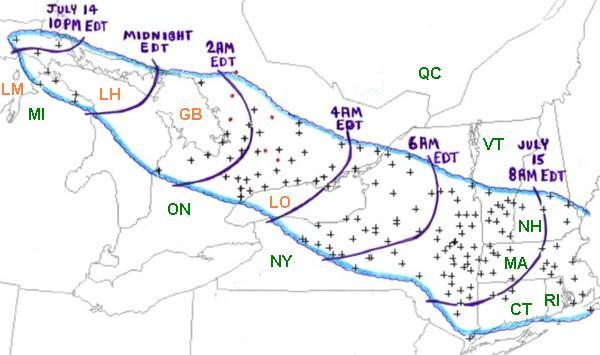
Figure 3. Area affected by July 14-15, 1995 derecho (outlined in blue). Curved purple lines represent approximate locations of the gust front at two-hourly intervals. "+" symbols indicate the locations of wind damage or wind gusts above severe limits (measured or estimated at 58 mph or greater). The red dots denote tornadoes.
On the evening of Friday, July 14th, 1995, thunderstorms producing severe weather were occurring over Upper Michigan (MI) and adjacent portions of Ontario (ON) near Sault Saint Marie. By late evening the storms had evolved into a bowing line just northwest of the Mackinac Bridge. At 10:17 PM EDT, the thunderstorm gust front hit the bridge and a gust to 90 mph was measured. Sustained winds above 80 mph continued on the bridge for 10 more minutes. Thus began the intense "Ontario-Adirondacks Derecho" that would cause hundreds of millions of dollars worth of damage, several deaths, and many injuries as it raced southeast from the northern Great Lakes to the Atlantic coast (Figure 3).
...ONTARIO...
As the bow echo system producing the derecho crossed northern Lake Huron (LH) and Georgian Bay (GB), it grew in scale and severe winds affected a large part of southern Ontario (ON) during the pre-dawn hours of Saturday, July 15th (Figure 3). Some damage occurred in the Toronto metropolitan area near the southern edge of the derecho, and a wind gust to 136 kph (85 mph) was measured at the Buttonville Airport just north of the city. However, the most severe damage, which likely was associated with wind gusts up to 160 kph (100 mph) or more, occurred along a band from the "Cottage Country" east of Georgian Bay to the northeastern corner of Lake Ontario (LO) and adjacent parts of the St. Lawrence River Valley. This swath of damage was associated with the most rapidly moving part of the bowed line, as depicted in this radar imagery loop from Environment Canada's King City, Ontario radar. While most of the damage was associated with intense straight-winds, several brief tornadoes occurred in the bowed line. Most were weak, but a strong F2 intensity tornado hit the town of Bridgenorth, destroying a marina and damaging 20 homes.
Particularly hard hit by the July 14-15, 1995 derecho was that part of south central Ontario east of Georgian Bay, with some of the most intense damage around the towns of Huntsville, Bracebridge, Orillia, Minden, and Fenelon Falls. Between 1:30 and 3:30 AM EDT on July 15th, thousands of trees were blown down, with some blocking roadways, severing electrical lines, and damaging or destroying homes and automobiles. Many mobile homes also were overturned or blown away. One person was killed and numerous people were injured. Most of the injuries involved cuts, bruises, and/or broken bones. On Pigeon Lake north of Peterborough, a house boat was overturned, trapping eight people for several hours until they were rescued after sunrise.
Extensive damage continued as the storm system moved southeast toward Lake Ontario and the St. Lawrence River. A roof was torn off a building in downtown Campbellford, and fallen trees blocked roads. The severe winds reached the eastern towns of Picton, Kingston, and Brockville around 4 to 4:30 AM EDT and then crossed into northern New York.
Power outages along the severe damage swath over south central Ontario would last for several days to a week. A report from the Insurance Bureau of Canada indicates that the July 14-15, 1995 derecho resulted in $53 million (in 1995 Canadian dollars) of insurance damage claims in Ontario.
...NEW YORK...
As the Ontario-Adirondacks Derecho entered New York (NY) around 4 to 4:30 AM EDT, very severe wind damage continued to occur, especially along the most bowed-out portion of the line of thunderstorms. Winds estimated to be 100 mph or greater occurred at several points along a band from Jefferson and western St. Lawrence Counties through the Adirondack Mountain region. Of the five deaths and 11 injuries associated with the derecho in New York, most were the result of trees falling on campers in the Adirondacks. Over 30 campers and hikers in the area had to be removed by helicopter since their paths out of the forest were blocked by thousands of fallen trees. According to the New York Dept. of Conservation, about 900,000 acres of forest were damaged in the state, and the value of the loss of timber was estimated to be over $200 million (in 1995 U.S. dollars).
In the more populated areas of central and eastern New York, almost $190 million damage was done to structures and vehicles. Many mobile homes were overturned and numerous homes and businesses were damaged. Many vehicles were damaged or destroyed by falling trees. At the Syracuse Airport, a wind gust of 76 mph was measured at 5:30 AM EDT as the storm gust front arrived, and a parked Boeing 727 jet plane was blown into another commercial jet. Less than an hour later, a gust of 77 mph was recorded at the Albany airport. Several hundred thousand people lost electrical power due to the powerful derecho winds.
Radar reflectivity imagery from Rome, New York (RMX) showing the bow echo as it entered northern New York may be found on the Albany, New York NWS Forecast Office web site here. (Note: As of March 2014, this link was no longer active, and an updated URL could not be found. However, the link will remain posted in the belief that those interested in further information might wish to contact the Albany forecast office individually). An animated radar view of the derecho-producing bow echo approaching the Albany area appears in Figure 4.

Figure 4. Ninety-minute "ping-pong" animation of base reflectivity radar data from NWS Albany, New York, showing the bow echo as it crossed the Adirondack Mountains and approached the Albany area (ENX) between 5:00 and 6:30 a.m. EST (0900-1030 UTC) July 15. The convective system extends southwest to near Binghamton (BGM). Range rings are in 30 nautical mile (nm) increments. The northern end of the bow echo contains a well-defined bookend vortex that at the end of the animation is located approximately 50 nm south-southwest of Burlington, Vermont (BTV). (Base data courtesy of J. Waldstreicher, NWS Albany).
...NEW ENGLAND...
The Ontario-Adirondacks Derecho entered western New England about 7 AM EDT on July 15th and passed offshore of Cape Cod by 9:30 AM EDT. Measured wind gusts in Massachusetts (MA) include 92 mph at Otis, 85 mph at Upton, 63 mph at Blue Hill Observatory, and 58 mph on Martha's Vineyard. Many roads were blocked by fallen trees and homes and cars were damaged. Fifty people were left homeless when the roof was blown off an apartment building in Holyoke. One person was killed and another injured by falling trees and power lines in western Massachusetts. Three others were injured in Deerfield when their hot air balloon was caught by the storm gust front and spun out of control for five miles before crashing into a tree.
...SUMMARY...
The Ontario-Adirondacks Derecho of July 14-15, 1995 was one of the most costly severe thunderstorm events to occur in eastern North American during the 20th century, causing nearly one-half billion 1995 U.S. dollars in damage. The derecho raced across an 800-mile path in eastern North America in 12 hours, at an average speed of 67 miles per hour. Seven people were killed and several dozen were injured. Many of these were hikers and campers visiting the forested regions of south central Ontario and the Adirondack Mountains in New York.
In total, the series of four derechos that occurred over central and eastern North America during mid-July 1995 resulted in 14 deaths, nearly 100 injuries, and between one-half and one billion dollars worth of damage. It was one of the more noteworthy series of derechos to have occurred in North America during the last 50 years.
_____________________________________________________________________________
[Data and other information on the July 13th and July 15th, 1995 derechos in Ontario were provided by Environment Canada meteorologists P. Chadwick, M. Leduc, P. Rodriquez, S. Scriver, and D. Sills.]
Additional information:
Bentley 1997
Bosart et al. 1998
Cannon et al.,
1998
Storm Data, July 1995
Back to Noteworthy Derechos List