APRIL 19-20, 2011 DERECHO
"The Ozarks / Ohio Valley Derecho of April 2011"
The cold front of a strengthening surface low served as the focus for intense thunderstorm development in an area of very unstable air over the Mid-Mississippi Valley and Ozarks on the afternoon of Tuesday, April 19, 2011. The scattered supercells that formed produced very large hail; softball-size (4.25 inches in diameter) stones pummeled eastern parts of Oklahoma and Missouri. The storms remained intense and increased in lateral extent after sunset. By midnight, an unbroken squall line containing several large-scale bow echoes --- that is, a classic, serial-type derecho-producing convective system --- extended from western Ohio to northeast Texas. The storms remained active through the night, producing numerous tornadoes in addition to more than 900 other reports of severe weather (Figure 1). A broad swath of the east central United States was affected, including much of the Ozarks as well as the lower Tennsessee and Ohio River Valleys. Although significant, the derecho's impact was overshadowed by deadly tornado outbreaks that occurred both shortly before (April 16 - North Carolina), and after (April 27 - Alabama, Mississippi, and Tennessee) the event.
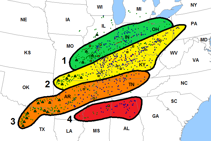
Figure 1. Storm reports associated with the April 19-20, 2011 derecho. Reports are for the 24-hour period from 7:00 a.m. CDT (1200 UTC) Tuesday, April 19 to 7:00 a.m. CDT Wednesday, April 20. Wind damage or wind gusts ≥ 50 kts (58 mph), small blue squares; estimated or measured wind gusts ≥ 65 kts (74 mph), large black squares with yellow centers; hail ≥ 0.75 inches, small green squares; hail ≥ 2.0 inches, large black triangles with green centers; tornadoes, small red squares. Black contours and colored-shaded areas depict the approximate paths of the four large-scale bow echoes (numbered 1-4) and their predecessary supercell storms that comprised the event. Each bow echo evolved from merging clusters of individual supercells. Note that, as is typical with convective systems of this type, the main threat with these initial storms was large hail, and that this hail fell primarly west of the Mississippi River. Attainment of bow echo configuration was marked by the onset of wind damage and/or observed severe wind gusts; this occurred mainly east of the Mississippi.
As already noted, the April 19-20, 2011 serial derecho arose from a band of supercell thunderstorms that formed along and ahead of a cold front associated with a developing surface low (Figure 2). The low tracked from eastern Kansas on the morning of the 19th to Lake Erie on the morning of the 20th (not shown). A deep fetch of warm, very moist air orginating over the southern Gulf of Mexico was present ahead of the front. The combination of abundant warmth and humidity with strong speed and directional shear (30 mph near-surface southerly flow veered to 50 mph southwesterly winds at mid-levels) provided a nearly ideal setup for the development of a serial derecho --- especially given the linear uplift provided by the front. Development also was fostered by afternoon heating and by the approach of a strong jet stream disturbance from the southern Rockies. The jet stream impulse enhanced upper-level divergence or "venting," and encouraged storm growth after dark as it continued east from the southern Plains into the Mississippi Valley (Figure 3).
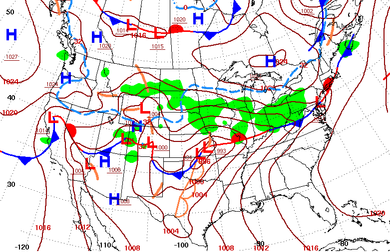
Figure 2. Surface analysis valid 7:00 a.m. CDT (1200 UTC) April 19, 2011, showing fronts (conventional symbols), isobars (brown; 4 mb increments), and continuous precipitation (green shading). Freezing isotherm (32 °F) depicted by dashed blue line (Courtesy NOAA-NWS-NCEP Weather Prediction Center).
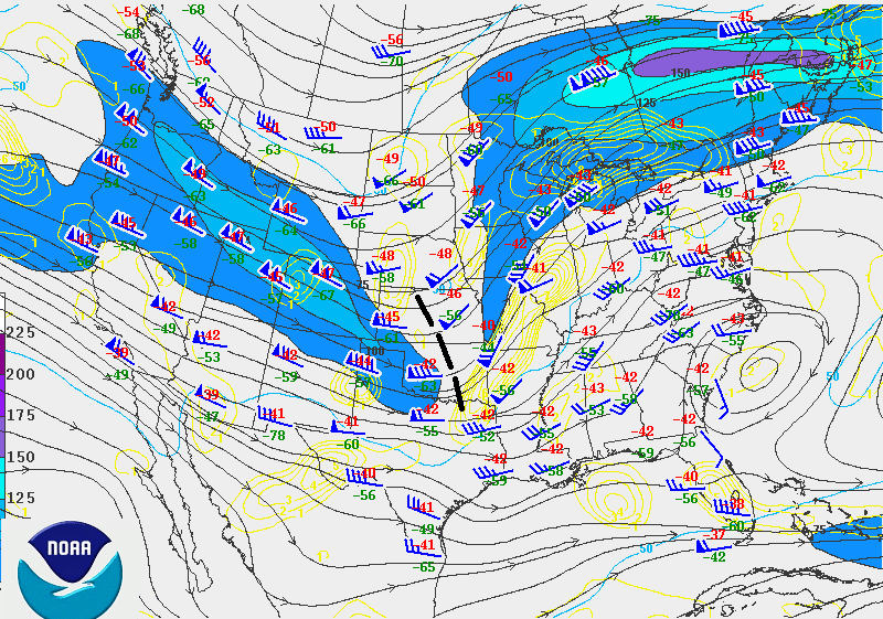
Figure 3. 300 mb (approximately 30,000 foot) analysis valid 7:00 p.m. CDT April 19 (0000 UTC April 20) 2011. Streamlines depicted by dark gray lines with arrows; divergence in yellow (s-1; contour increment one unit). Isotachs of wind speeds greater than or equal to 50 kts (58 mph) in blue (contour increment 25 kts (29 mph)); speeds greater than 75 kts (86 mph) shaded in blue and purple. Temperature and dewpoint (red and green numerals, respectively) plotted next to station circles. Heavy, black dashed line in Kansas and Oklahoma denotes jet stream disturbance mentioned in text; this feature reached eastern Illinois, western Kentucky, and western Tennessee by 7:00 a.m. (1200 UTC) April 20 (NOAA-NWS-NCEP Storm Prediction Center).
The convective system responsible for the April 2011 Ozarks / Ohio Valley derecho was composed of four separate large-scale bow echoes (Figure 1). Through mid to late evening, the first three of these bows were co-joined within an extensive squall line that reached from central portions of Indiana and Ohio south-southwest into eastern Arkansas, western Tennessee, and northern Mississippi. It was during this period that the event was most destructive. A fourth bow echo evolved during the early morning of April 20th over northern Mississiipi. This system continued east across northern Alabama through sunrise, long after the earlier bows had significantly weakened.
The first and northern-most bow echo formed around 7:00 p.m. (Note: All times Central Daylight, unless otherwise stated) along an arc extending from east central Illinois southwestward to near St. Louis. The bow appeared to arise largely as a result of mergers between pre-frontal ("warm-sector") thunderstorms that had formed earlier in the evening near St. Louis, with those along the cold front (Figures 4-7). As the faster-moving frontal storms overtook those in the warm sector, the convection increased in both intensity and depth. The storms accelerated east-northeastward, likely in response to increased interaction with the seasonably strong mid and upper-tropospheric flow (Figure 3). The fast, unidirectional west-southwesterly winds aloft and the concentrated area of storm development encouraged rapid consolidation and downstream elongation of the cold, low-level storm outflow (see discussion on cold pool elogation in Derechos and Flash Floods).
By mid-evening, the expansive cold pool had surged into central Indiana, producing 75-80 mph surface wind gusts in central Illinois. In addition to widespread tree and power line damage, roofs were blown off part of a school in St. Louis, and off a shopping center and a machinery building near Ft. Wayne (Indiana). Tractor-trailers were flipped near Centralia, Illinois, and trailer was twice rolled and destroyed in eastern Indiana. Multiple vehicles were blown off Interstate 65 northwest of Indianapolis. There were also scattered reports of structural damage to buildings eastward into Ohio. Storm surveys after the event suggested that some of this damage was due to small tornadoes that occurred in association with embedded circulations along the squall line (see Tornadoes and Other Circulations). One of these tornadoes had a path length of nearly four miles and produced a 102 mph measured gust in Licking County (southeast of Columbus). Earlier in the evening, another tornado destroyed several homes and left people trapped by debris near Girard, Illinois (northeast of St. Louis). A close-up radar reflectivity and velocity view of the bow echo over eastern Illinois (with a bookend vortex at the northern end of the system) appears in Figure 4.
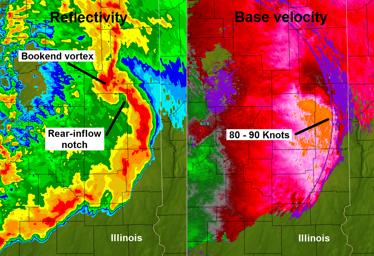
Figure 4. Reflectivity (left) and base velocity (right) views of the first (northern-most) bow echo over eastern Illinois, as seen by the Lincoln, Illinois (KILX) NWS radar at 0100 GMT 20 April. The images show a bookend vortex at the northern end of the bow, and a corridor of reduced reflectivity (known as a "rear-inflow notch") south of the vortex that marks the location of the system's rear-inflow jet. The rear-inflow jet is associated with a swath of 80-90 kt westerly winds (orange shading) behind the bow's apex. At this distance from the radar (approximately 65 nmi.), the elevation of the radar beam is about 6000 ft. (Radar data courtesy of Lee Grenci, The Pennsylvania State University)
In addition to the presence of deep, largely unidirectional tropospheric flow and ample moisture and instability, development of the northern bow echo likely was also fostered, in part, by the presence of the west-east warm front over the mid-Mississippi/lower Ohio Valley (Figure 2). This boundary had been the focus of strong to severe thunderstorms early in the day (see first part of animation in Figure 3), and likely hastened development of the bow as the incipient storm line evolved over eastern Missouri and western Illinois during the early evening. Coupled with the deep unidirectional flow, the boundary also encouraged the formation of quasi-stationary bands of storms in the wake of the bow (as discussed in Derechos and Flash Floods). These "echo-training" bands produced local areas of flash flooding in Illinois and Indiana as the evening rains fell on areas left saturated by the morning storms.
The second bow echo arose not long after the first one in south-central Missouri. It, too, formed as a result of mergers between pre-frontal thunderstorms (in this case, over northern Arkansas and far southern Missouri) with those along the cold front (Figures 5-7). This bow evolved very quickly as it swept east-northeast across southeast Missouri and southern Illinois; by 10:00 p.m. it had reached the city of Evansville in southwest Indiana. The bow continued east-northeastward into southern Ohio after midnight (Eastern time). The system finally weakened shortly before dawn as it encountered diminished low-level instability over the western slopes of the Appalachians in West Virginia and eastern Kentucky. In the meantime, the bow had carved a nearly continuous swath of damage that extended from southeast Missouri to southwest Ohio, with the most intense activity affecting southern Illinois and western Kentucky.
Significant wind damage began in southeast Missouri, where estimated 70-75 mph gusts occurred near Marble Hill (west of Cape Girardeau). In Cape Girardeau, damage to trees was widespread, and storm winds blew a heating and air conditioning unit off the roof of a high school. In southern Illinois, part of the Carbondale police station roof was removed. More damage occurred when the roof subsequently landed on three nearby homes. Measured gusts reached 95 mph in Alexander and Johnson counties, and tree damage was described as "widespread" eastward to the Indiana border. In Indiana, winds gusted to 75 mph in Evansville. A bit farther east, storm winds overturned mobile homes in Jasper, and tore half the metal roof off a home near Paoli. Just south of the Ohio River in Kentucky, 75 mph winds blasted the Owensboro area. Tree and power line damage extended east from Owensboro through Louisville into much of eastern Kentucky. A 68 mph gust hit Capital City Airport in Frankfort, and near Covington (across the Ohio River from Cincinnati), estimated 80-120 mph winds damaged a rest stop and blew tractor-trailers off the road on Interstate 75. In southwest Ohio, a 79 mph gust was recorded at the National Weather Service office near Wilmington, where the roof of a nearby aircraft hangar was partly removed.
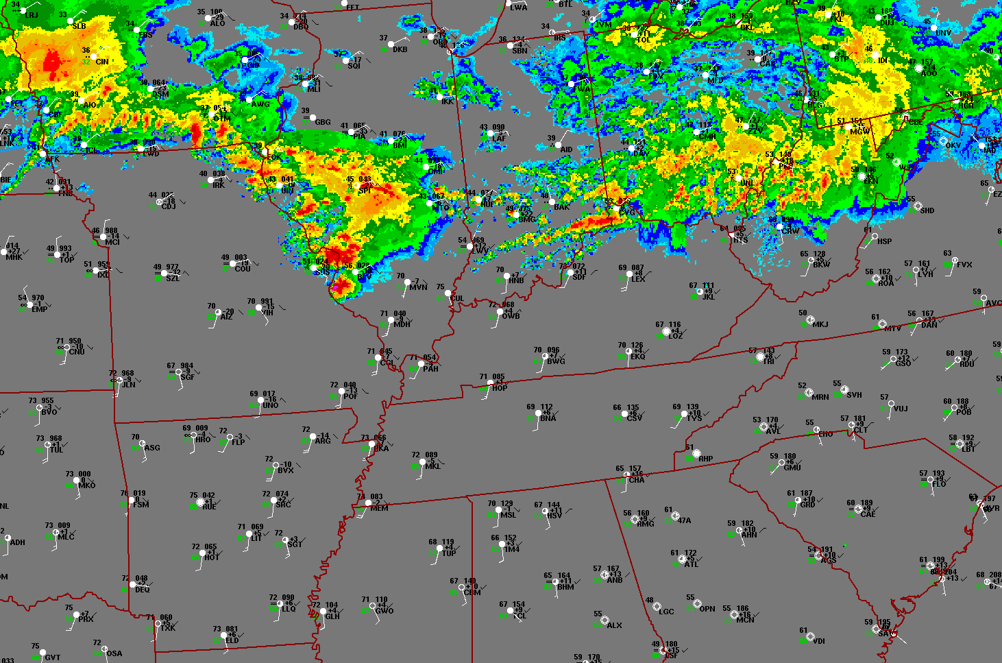
Figure 5. Twenty-four-hour composite radar base reflectivity loop showing development, evolution, and demise of the Ozarks / Ohio Valley serial-type derecho-producing convective system of April 19-20, 2011. The loop also shows weaker, on-going convective systems present along west-east warm front over the Ohio Valley on the morning of April 19. "Ping-pong" animation begins at 7:00 a.m. CDT (1200 UTC) Tuesday, April 19, and ends at 7:00 a.m. CDT (1200 UTC) Wednesday, April 20. Reflectivity intensity scale not shown, but stronger returns (higher dBZ values) depicted in orange and red. Surface data plotted using conventional format, with standard three-letter station identifiers: Temperature / dew point (°F, with dewpoint in green) on left, and pressure / pressure tendency (mb) on right. White lines / barbs depict wind direction and speed (knots; one full barb = 10 knots = 11.5 mph).
Figure 6. Twenty-four-hour infrared data satellite loop showing development, evolution, and demise of the Ozarks / Ohio Valley serial-type derecho-producing convective system of April 19-20, 2011. The loop also shows weaker, on-going convective systems present along west-east warm front over the Ohio Valley on the morning of April 19. "Ping-pong" animation begins at 6:45 a.m. CDT (1145 UTC) April 19 and ends at 6:45 a.m. CDT (1145 UTC) April 20. Cloud-to-ground lightning strikes (red crosses) and surface data (using conventional station plot format, as in Figure 2) also shown.
The third bow echo formed from merging supercell storms near Little Rock, Arkansas around 9:00 p.m. This system also accelerated rapidly east-northeastward, reaching the Memphis (Tennessee) area before 11:00 p.m. The bow then continued east-northeast across the remainder of western and middle Tennessee and extreme southern Kentucky through the overnight, before finally weakening over eastern Tennessee around 5:00 a.m. (Eastern time).
Early in its development, the storm's outflow winds uprooted trees in Jefferson County (southeast of Little Rock), resulting in gas line rupture and a gas leak. In northeast Arkansas, measured 95 mph winds blew a large outbuilding off its foundation and onto a roadway. Tractor-trailers were blown over in Crittenden County, just across the Mississippi River from Memphis, and a roof was blown off a nearby business building. In Memphis, measured 70 mph winds snapped trees and power poles. Damage to trees was especially acute in parts of Carroll, Gibson, Henry, and Weakley Counties in west Tennessee, with many trees downed on houses and cars. Power outages were widespread. The high winds became more intermittent in middle Tennessee, although scattered areas of damage continued to occur. Bricks and parts of the roof of a building were removed in downtown Nashville.
The fourth and final bow echo of the April 2011 serial derecho formed around 4:00 a.m. on April 20th over northeast Mississippi as the earlier bow systems weakened farther north. The Mississippi bow evolved from a broken line of thunderstorms that had developed much earlier in the night near the cold front as that boundary crossed the Arklatex (Figure 5). As the storms moved through southern Arkansas and northwest Mississippi, they produced only sporadic instances of severe weather, tracking as they did through a region that had been overturned by prior convection. Once the storms neared Tupelo, however, they encountered air that had not been stabilized by recent convection. This resulted in an abrupt increase in updraft strength and organization. The storms quickly assumed a large-scale bow configuration that continued east through northern Alabama during the remainder of the pre-dawn hours, and reached northern Georgia after sunrise.
In the Tupelo area, winds gusted to more than 65 mph, toppling trees and power lines. The bow further strengthened as it moved into Alabama. Downed trees damaged houses in Madison County, and roofs were blown off homes in Bear Creek. South of Huntsville, one person was injured when a tree fell on a house near Florette. Another person suffered injury in a similar incident near Holly Pond. The damage continued east into northeastern Alabama, where a metal roof was removed by high winds and a secured trailer was flipped in Jackson County. More isolated damage extended south into central Alabama, and east into far northwest Georgia around dawn.
Figure 7. Twelve-hour visible data satellite loop showing development of the April 19-20, 2011 derecho-producing convective systems over the Ozarks and mid-Mississippi Valley, and dissipation of on-going, weaker convective systems over the Midwest and Ohio Valley. "Ping-pong" animation begins at 7:30 a.m. CDT (1230 UTC; sunrise) April 19 and ends at 7:30 p.m. CDT April 19 (0030 UTC April 20; sunset). Surface data also shown, using conventional format as in Figure 2.
The April 2011 Ozarks / Ohio Valley derecho was one of the more classic serial-type events to have occurred in recent years. Numerous "cool-season" (generally considered to be October through April) damaging wind-producing convective events occur each year. Most of these are characterized by a narrow band of "forced convection" (thunderstorms) formed by uplift along a cold front associated with a strong jet stream disturbance. Typically these lines remain located with the immediate cold front during the life of the event and do not develop appreciable forward-propagating line segments that evolve into large-scale bow echoes. For example, an extensive line of thunderstorms accompanied a cold front that crossed the central and eastern United States on April 4-5, 2011, just two weeks prior to the April 19-20 serial derecho. While the April 4-5 squall line was responsible for nearly 1500 reports of severe weather (most of which were downed trees and tree limbs), large scale bows did not develop, and measured severe wind gusts were nearly absent. In contrast, the April 19-20, 2011 case featured a strong forward-propagating component to system movement that enabled storms to move well ahead of the parent cold front in the form of four, separate large-scale bow echoes. Each bow produced a swath of significant severe weather. During part of the evening, three of the bow echoes were present simultaneously, joined into one extensive squall line that exhibited classic line-echo wave patterns (Figure 5). Had the April 19-20, 2011 serial derecho not occurred in the middle of one of the most active periods of severe convective weather in recent history, it likely would be more widely remembered.
_____________________________________________________________________________
Additional information (arranged geographically from west to east):
Northern-most bow echo:
St. Louis, Missouri NWS Office - Description of early-day storms, and discussion of tornadoes and other severe weather with northern-most derecho-producing bow echo (early evening)
Central Illinois NWS Office - Description of early-day storms and discussion of impact of northern-most derecho-producing bow echo in central Illinois (early to mid evening)
Indianapolis, Indiana NWS Office - Description and impact of northern-most derecho-producing bow echo in central Indiana (mid evening)
Northern Indiana NWS Office - Evolution of the northern-most derecho-producing bow echo over northeast Indiana and northwest Ohio (late evening)
Second bow echo:
Paducah, Kentucky NWS Office - Evolution and impact of the second derecho-producing bow echo over southeast Missouri, western Kentucky, and southern Illinois (mid evening)
Louisville, Kentucky NWS Office - Tornadoes associated with the second derecho-producing squall line over parts of Kentucky and southern Indiana (late evening)