Doppler Radar
Doppler radar can see not only the precipitation in a thunderstorm (through its ability to reflect microwave energy, or reflectivity), but motion of the precipitation along the radar beam. In other words, it can measure how fast rain or hail is moving toward or away from the radar. From a volume scan (a series of 360-degree sweeps, each tilting a little higher than the last), forecasters can get a detailed look at structures and movements in storms close to the radar. The farther away from the radar a storm is, the more coarse the view, because: 1) The radar beam spreads out with distance, like a flashlight beam, causing small features to be missed at a distance; and 2) The beam shoots straight as the earth curves away from beneath -- a horizon that forces the radar to miss more and more of the low and middle levels of a storm with distance.
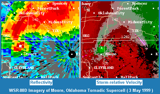
In the dual image at left, the radar was unusually close to an F5 tornado in northern Moore, Oklahoma -- close enough to make out signatures of the tornado itself. [Most of the time, one can only detect the weaker and larger mesocyclone -- the circulation that could spawn a tornado.] This large, violent and extremely destructive tornado was hurling many tons of debris high into the air as it approached I-35. The debris, which reflects radar energy much stronger than rain does, caused the brightest white blocks of reflectivity within the hook echo. To make a storm-relative velocity image, the radar system's computer programs take away thunderstorm movement to give a truer look at the motions inside the storm. Here, the mesocyclone and tornado in northern Moore are represented by progressively brighter greens (toward the radar) and reds (away from the radar).
Doppler radar and severe storms research were joined in the early 1960s when the National Severe Storms Project began in Kansas City, and continue to this day at the National Severe Storms Laboratory (NSSL) in Norman, Oklahoma. The Union City tornado in 1973 began a treasure trove of NSSL research Doppler measurements of supercells and other hazardous storms. In the 1980s, the push to get Doppler radars into warning operations became well-organized as the NEXRAD (NEXt generation weather RADar) program. In 1989, organized intercept teams went out into severe storms to verify the indications of a prototype NEXRAD radar in Norman. Based on those field observations and research into other storm events since then, computer programs (algorithms) to detect harmful features in storms were developed -- and continue to be developed and modified today. Algorithms help forecasters to see where hail, heavy rain, severe downdrafts and tornadoes may form; but trained spotters are still just as important as ever to report what is really happening under the radar beam.
In the early to mid 1990s, a national network of over 100 WSR-88D Doppler radar sites was built as part of the modernization of the National Weather Service. These radars since have been retrofitted with dual-polarized technology, firing waves aligned both horizontally and vertically. Computer programs measure the differences between the vertical and horizontal wave returns to better detect different kinds of precipitation (small raindrops, large drops, hail, snow) and other echo returns like chaff, wildfire smoke, bats and birds, insects, and airborne tornado debris.
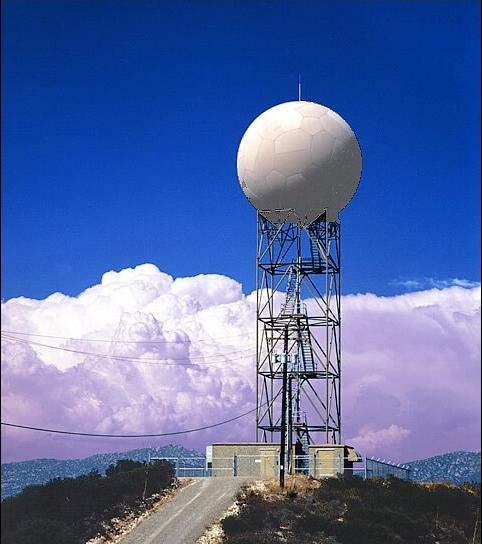
To learn more about Doppler radar, see the NSSL radar page. For more information on the WSR-88D system and the NEXRAD program, check out the Radar Operations Center (ROC) in Norman. The bottom photo at left shows a typical WSR-88D radar unit.