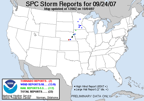
20070924's Storm Reports
|
< 070923 Reports
070925 Reports >
|
|
| Note: All data are considered preliminary |
| Tornado Reports (in CSV format) |
|---|
Time | | Location | County | State | Lat | Lon | Comments |
| 2320 | | BLUE HILL | WEBSTER | NE | 4033 | 9845 | (GID) |
| 2327 | | 4 SE AYR | ADAMS | NE | 4040 | 9839 | (GID) |
| Hail Reports (in CSV format) |
|---|
Time | Size | Location | County | State | Lat | Lon | Comments |
| 2010 | 88 | 8 E MELVIN | OSCEOLA | IA | 4329 | 9545 | PUBLIC REPORT RELAYED BY RADIO STATION. LOCATION IS JUST SOUTHEAST OF MAY CITY. (FSD) |
| 2245 | 100 | 8 NE WEST POINT | CUMING | NE | 4192 | 9660 | (OAX) |
| 2300 | 100 | LYONS | BURT | NE | 4194 | 9647 | (OAX) |
| 2327 | 125 | 4 W AYR | ADAMS | NE | 4044 | 9852 | (GID) |
| 2345 | 75 | 2 NE CASTANA | MONONA | IA | 4209 | 9588 | HAIL UP TO 3/4 INCH AND WINDS ESTIMATED AT 60 MPH. (OAX) |
| 0430 | 200 | DAVID CITY | BUTLER | NE | 4125 | 9713 | REPORTED BY COOP OBSERVER AND EMERGENCY MANAGER. (OAX) |
| 0446 | 200 | 4 NE OCTAVIA | BUTLER | NE | 4139 | 9700 | (OAX) |
| Wind Reports (in CSV format) |
|---|
Time | Speed | Location | County | State | Lat | Lon | Comments |
| 1925 | UNK | LITTLE FALLS | MORRISON | MN | 4598 | 9436 | TWO TREES DOWN. (MPX) |
| 2100 | 60 | PALISADE | AITKIN | MN | 4671 | 9349 | (DLH) |
| 2113 | 58 | 2 N LESTER PRAIRIE | MCLEOD | MN | 4491 | 9404 | MEASURED BY MNDOT SENSOR. (MPX) |
| 2142 | 67 | NORTH MANKATO | NICOLLET | MN | 4418 | 9403 | (MPX) |
| 2145 | UNK | KASOTA | LE SUEUR | MN | 4429 | 9397 | TREE DOWN ON POWER POLE. (MPX) |
| 2148 | UNK | 2 W ST PETER | NICOLLET | MN | 4433 | 9400 | LARGE TREE LIMB DOWN. SMALL HAIL ALSO REPORTED. (MPX) |
| 2220 | UNK | 2 SSW CARVER | CARVER | MN | 4473 | 9364 | TREE DOWN ACROSS COUNTY ROAD 45. (MPX) |
| 2240 | UNK | 5 E PRIOR LAKE | SCOTT | MN | 4473 | 9333 | TREE DOWN ON POWER LINE. (MPX) |
| 2305 | UNK | 8 WSW DECATUR | BURT | NE | 4196 | 9639 | NUMEROUS TREES DOWN AND WINDOWS IN A HOUSE WERE BLOWN IN AT A LOCATION 6 MILES WEST AND 3 MILES SOUTH OF DECATUR. WINDS ESTIMATED TO BE OVER 80 MPH. (OAX) |
| 2323 | UNK | 4 W DODGE CENTER | DODGE | MN | 4403 | 9293 | LARGE DUMPSTER MOVED 50 FT, TIN STRIPPED OFF BARN, 2 OUTBUILDINGS DESTROYED, LEAVES STRIPPED OFF TREES, LOST SEVERAL LARGE TREES IN YARD (ARX) |
| 2350 | 70 | 4 SW MAPLETON | MONONA | IA | 4213 | 9585 | WINDS ESTIMATED AT UP TO 70 MPH ABOUT 4.5 MILES SOUTHWEST OF MAPLETON. (OAX) |
| 0005 | 60 | 6 ESE CLAY CENTER | CLAY | NE | 4049 | 9795 | (GID) |
| 0019 | 70 | SHICKLEY | FILLMORE | NE | 4042 | 9772 | (GID) |
| Full report
in comma-separated values (CSV) format |
| Fields marked UNK are unknown |
| All Times UTC |
| Wind Gusts in MPH |
| Hail Sizes in 1/100 of an Inch (75 = 0.75") |
| List of Weather Forecast Office 3-letter IDs appear in the report comments section |
|
|
|
Top/Storm Reports/Home
|


 @NWSSPC