| Tornado Reports (CSV) (Raw Tornado CSV)(?) |
|---|
| No reports received |
| Hail Reports (CSV) (Raw Hail CSV)(?) |
|---|
Time | Size | Location | County | State | Lat | Lon | Comments |
| 2008 | 125 | 6 SSE Cornell | Chippewa | WI | 4509 | 9112 | Time estimated based on radar. Spotter also reported gusty winds but no large branches were down. (MPX) |
| 2018 | 100 | 2 E Kimberly | Jefferson | AL | 3377 | 8676 | Social media video of quarter-size hail near Kimberly. (BMX) |
| 2034 | 175 | 1 S Osseo | Trempealeau | WI | 4456 | 9122 | half dollar to golf ball size hail. (ARX) |
| 2054 | 150 | 7 WNW Humbird | Jackson | WI | 4456 | 9102 | (ARX) |
| 2058 | 100 | Fairchild | Eau Claire | WI | 4460 | 9096 | Quarter sized hail reported. (MPX) |
| 2103 | 150 | Fairchild | Eau Claire | WI | 4460 | 9096 | Trained spotter reported hail between 1 inch and 1.5 inches in diameter coating the ground. (MPX) |
| 2106 | 100 | 1 E Blair | Trempealeau | WI | 4430 | 9121 | (ARX) |
| 2110 | 100 | 8 W Phillips | Price | WI | 4569 | 9057 | Public estimated hail the size of a quarter on the southwest side of Lac Sault Dore. (DLH) |
| 2119 | 200 | Chelsea | Taylor | WI | 4529 | 9031 | Corrects previous hail report from Chelsea. Size was determined from a picture on WAOW Facebook. (ARX) |
| 2137 | 100 | Rib Lake | Taylor | WI | 4532 | 9020 | (ARX) |
| 2147 | 150 | 8 NNW Mercer | Iron | WI | 4627 | 9015 | Public report of hail ranging from Quarter to golf ball sized hail on Pine Lake in central Iron County. (DLH) |
| 2152 | 150 | Bessemer | Gogebic | MI | 4648 | 9005 | Picture via Facebook of two large hailstones next to a quarter. Time estimated by radar. (MQT) |
| 2154 | 100 | Lake Arbutus | Clark | WI | 4443 | 9069 | Hailed for about 1 minute. (ARX) |
| 2157 | 200 | Bessemer | Gogebic | MI | 4648 | 9005 | Social media reports with pictures and videos of large hailstones. Time estimated by radar and size estimated by photos. (MQT) |
| 2200 | 200 | Ironwood | Gogebic | MI | 4646 | 9015 | Report via Twitter of 1.5 and 2 inch hail on a measuring tape. Measured after the storm had passed. (MQT) |
| 2206 | 125 | 1 SSE Rib Lake | Taylor | WI | 4531 | 9020 | (ARX) |
| 2206 | 150 | 1 ENE Ironwood | Gogebic | MI | 4646 | 9013 | Picture received showing hailstones larger than a quarter. Time estimated by radar. (MQT) |
| 2215 | 100 | 4 SW Lac Du Flambeau | Vilas | WI | 4592 | 8994 | (GRB) |
| 2219 | 200 | Chelsea | Taylor | WI | 4529 | 9031 | Size was determined from a picture on WAOW Facebook. (ARX) |
| 2220 | 100 | Ewen | Ontonagon | MI | 4653 | 8928 | Hail lasted 5-10 minutes. (MQT) |
| 2225 | 125 | Woodruff | Vilas | WI | 4590 | 8969 | (GRB) |
| 2230 | 100 | 2 N Dorchester | Clark | WI | 4503 | 9033 | (ARX) |
| 2235 | 100 | Arbor Vitae | Vilas | WI | 4592 | 8966 | (GRB) |
| 2241 | 100 | 1 WSW Florida Gardens | Palm Beach | FL | 2661 | 8019 | Social media report of quarter sized hail near Lyons Road and Gulfstream Preserve as a severe thunderstorm moved through the area. Time estimated via radar. (MFL) |
| 2247 | 100 | 2 NE Aberdeen Golf Cour | Palm Beach | FL | 2659 | 8015 | Photos of quarter-sized hail at intersection of Lantana and Jog Roads. (MFL) |
| 2248 | 100 | 2 SE Goodrich | Taylor | WI | 4513 | 9006 | (ARX) |
| 2255 | 100 | Irma | Lincoln | WI | 4534 | 8966 | WSAW-TV relayed report of 1 inch hail in Irma. (GRB) |
| 2338 | 100 | 2 SE Port Edwards | Wood | WI | 4431 | 8983 | Corrects previous hail report from 2 SE Port Edwards. Report from mPING: Quarter (1.00 in.). (GRB) |
| 2339 | 100 | Calumet | Houghton | MI | 4725 | 8845 | Media partner forwarded photo of hailstones estimated to be quarter-sized. Time estimated by radar. (MQT) |
| 2344 | 100 | Calumet | Houghton | MI | 4725 | 8845 | Facebook report with picture of 1 hail from Calumet. Time estimated by radar. Size estimated by reporter. (MQT) |
| 0000 | 100 | 2 E Wisconsin Rapids | Wood | WI | 4440 | 8980 | Trained spotter reported 1 inch hail. Location estimated. (GRB) |
| 0003 | 100 | 2 WNW Almond | Portage | WI | 4427 | 8943 | Trained spotter reported quarter inch hail along with an estimated 70 mph wind gusts. Report of a tree sown over the road. (GRB) |
| 0004 | 100 | 2 S Biron | Wood | WI | 4439 | 8979 | Portage County Emergency Manager reported 1 inch hail in Wisconsin Rapids. (GRB) |
| 0010 | 125 | 4 SW Bosstown | Richland | WI | 4332 | 9065 | (ARX) |
| 0019 | 100 | Boaz | Richland | WI | 4333 | 9053 | (ARX) |
| 0038 | 100 | 2 SE Port Edwards | Wood | WI | 4431 | 8983 | Report from mPING: Quarter (1.00 in.). (GRB) |
| 0103 | 100 | 2 SW Beecher | Marinette | WI | 4555 | 8800 | (GRB) |
| 0151 | 100 | 2 ESE Kingsford | Dickinson | MI | 4580 | 8806 | (MQT) |
| 0154 | 100 | 3 SSW Wiley | Prowers | CO | 3811 | 10274 | Reported via social media. (PUB) |
| Wind Reports (CSV) (Raw Wind CSV)(?) |
|---|
Time | Speed | Location | County | State | Lat | Lon | Comments |
| 1226 | UNK | Choctaw Beach | Walton | FL | 3047 | 8635 | Multiple trees down across the road. (TAE) |
| 1300 | UNK | 1 S Ponce de Leon | Walton | FL | 3070 | 8594 | Report from the public on social media of several trees down on paved roads in the Walton County portion of Ponce de Leon. (TAE) |
| 1300 | UNK | 3 WSW Marley Hill | Dale | AL | 3148 | 8574 | Tree down on County Rd 38 and County Rd 104. (TAE) |
| 1307 | UNK | Black | Geneva | AL | 3101 | 8574 | Numerous trees reported down across Black. (TAE) |
| 1309 | UNK | 1 N Ewell | Dale | AL | 3143 | 8558 | Damage reported to a carport. (TAE) |
| 1320 | UNK | Hartford | Geneva | AL | 3110 | 8570 | Numerous trees reported down across Hartford. (TAE) |
| 1325 | UNK | 2 E Fadette | Geneva | AL | 3104 | 8551 | Trees reported down and impacting homes. Time estimated by radar. (TAE) |
| 1325 | UNK | Slocomb | Geneva | AL | 3111 | 8559 | Numerous trees reported down across Slocomb. (TAE) |
| 1330 | UNK | 1 SE Headland | Henry | AL | 3134 | 8533 | Tree down across Holman Dr. (TAE) |
| 1333 | UNK | 2 ESE Sylvan Grove | Dale | AL | 3134 | 8543 | Tree down on County Rd 14 and County Rd 79. (TAE) |
| 1346 | UNK | 1 NW Lovetown | Houston | AL | 3113 | 8529 | Trees down across the road. (TAE) |
| 1349 | UNK | 3 E Jacobs | Jackson | FL | 3089 | 8537 | Trees down across Jacob Rd. (TAE) |
| 1355 | UNK | 2 WNW Bradford | Washington | FL | 3066 | 8559 | Corrects time of previous tstm wnd dmg report from 2 WNW Bradford. Trees down near Tiller Rd and Owens Pond rd. (TAE) |
| 1357 | UNK | 3 E Jacobs | Jackson | FL | 3089 | 8537 | Corrects time of previous tstm wnd dmg report from 3 E Jacobs. Trees down across Jacob Rd. (TAE) |
| 1434 | UNK | 4 N Grand Ridge | Jackson | FL | 3076 | 8501 | Trees down across waterberry ln. (TAE) |
| 1505 | UNK | 2 WNW Bradford | Washington | FL | 3066 | 8559 | Trees down near Tiller Rd and Owens Pond rd. (TAE) |
| 1930 | UNK | 1 SSW Bassville Park | Lake | FL | 2882 | 8177 | Trained spotter reports powerlines down and several trees down at the intersection of State Road 44 and County Road 473. (MLB) |
| 1935 | UNK | Lisbon | Lake | FL | 2887 | 8178 | HAM radio relayed a report of downed trees and powerlines near the intersection of State Road 44 and Emeralda Ave. (MLB) |
| 2003 | UNK | 2 E Woodlawn | Carroll | VA | 3671 | 8078 | Trees down on Breezy Rich Road. (RNK) |
| 2011 | UNK | 3 N Section | Jackson | AL | 3463 | 8598 | Two large trees were knocked down onto CR 67 about 3/4 miles west of Highway 35. Time estimated by radar. (HUN) |
| 2012 | UNK | 2 ENE Kimberly | Jefferson | AL | 3378 | 8677 | Several trees were downed along Mosley Loop Rd ... Bone Dry Rd ... and Bradford Tafford Rd east of Kimberly. (BMX) |
| 2013 | UNK | 2 S Dobson | Surry | NC | 3637 | 8072 | Thunderstorm winds blew down one tree near the intersection of Cody Trail and Garden Ridge Lane. (RNK) |
| 2016 | UNK | 1 NE Crutchfield | Surry | NC | 3629 | 8071 | Thunderstorm winds blew down one tree near the 600 block of Chandler Road. (RNK) |
| 2028 | UNK | 2 W Village Springs | Jefferson | AL | 3376 | 8668 | Social media images of trees down across Old Tennessee Pike Rd and across Highway 75 at Blount/Jefferson county line. (BMX) |
| 2031 | UNK | 1 NNE Village Springs | Blount | AL | 3377 | 8663 | Relayed through social media ... power poles broken on Highway 75 near Blount/Jefferson County line. (BMX) |
| 2041 | UNK | 1 N Argo | St. Clair | AL | 3372 | 8652 | Power lines down along Will Keith Rd at Weems Rd. (BMX) |
| 2045 | UNK | 1 NE Springville | St. Clair | AL | 3378 | 8647 | Social media report of a large tree snapped along Forrest Dr in Springville. (BMX) |
| 2050 | UNK | 4 ESE North Wilkesboro | Wilkes | NC | 3614 | 8107 | 3 trees down. 1 at the Wilkesboro Speedway and 2 in Wilkesboro. Several tents were also blown down at the racetrack. (RNK) |
| 2055 | UNK | 2 E Monroeton | Rockingham | NC | 3628 | 7970 | Thunderstorm winds blew down one tree near the intersection of Flat Rock Road and Lake Meadows Drive. (RNK) |
| 2100 | UNK | East Bend | Yadkin | NC | 3622 | 8051 | Several Trees down in town. (RNK) |
| 2100 | UNK | 4 E Nebo | Yadkin | NC | 3622 | 8058 | Trees Down along Fall Creek School Road. (RNK) |
| 2100 | UNK | Boonville | Yadkin | NC | 3623 | 8071 | Tree down. (RNK) |
| 2210 | UNK | Kepler | Hawkins | TN | 3640 | 8288 | Tree down. (MRX) |
| 2212 | UNK | 2 N Romeo | Greene | TN | 3632 | 8293 | Tree down. (MRX) |
| 2312 | UNK | Babcock | Wood | WI | 4429 | 9013 | Tree branches down. (GRB) |
| 2318 | UNK | Ocean Ridge | Palm Beach | FL | 2653 | 8005 | Social media report of several large tree branches and snapped trees as a severe thunderstorm moved through the area. Location is just south of where a weather station (MFL) |
| 0028 | UNK | 5 SW Deatsville | Autauga | AL | 3257 | 8646 | Trees down on Cedar Ridge Loop and CR 107 in Pine Level. (BMX) |
| 0033 | UNK | 5 SSW Deatsville | Autauga | AL | 3255 | 8644 | A few trees and power lines down along CR 85 southeast of Pine Level. (BMX) |
| 0040 | UNK | 1 NW Millbrook | Elmore | AL | 3249 | 8638 | Numerous trees down on several roadways in the Millbrook area. (BMX) |
| 0042 | 62 | 3 W Wetumpka Muni Airpo | Elmore | AL | 3253 | 8639 | (BMX) |
| 0044 | UNK | 1 SSW Coosada | Elmore | AL | 3248 | 8634 | A few trees were blown down between Coosada and Millbrook. (BMX) |
| 0046 | UNK | Coosada | Elmore | AL | 3250 | 8633 | Trees down near Coosada. (BMX) |


 @NWSSPC
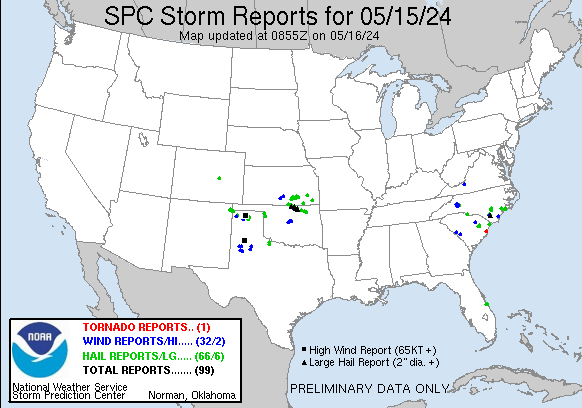
